Guan Changbai 丨 "Jilin No. 1" satellite "glance"?
Author:Jilin Radio and TV Station Time:2022.09.24
Today's autumn equinox is also the harvest festival of Chinese farmers. The joy of harvest is overflowing on the land of the motherland.

From the plain to the terraces, from the inland to the seaside, the "Jilin No. 1" satellite records the beautiful harvest scenes of the vast gesture on the vast land of China.

Not just records. At present, "Jilin One" is my country's largest commercial remote sensing satellite constellation. At this stage, 70 satellites are available at this stage, helping to accurately agriculture, smart forestry, ecological environmental protection and monitoring and other industries. Symbiosis Earth is a mobile remote sensing service application independently developed by Changguang Satellite Technology Co., Ltd. based on the remote sensing satellite constellation "Jilin No. 1".

"Recently, we have performed remote sensing monitoring of crop planting space for Changchun through the" Jilin No. 1 "satellite. In popular terms, that is, to calculate the corn, rice, soybeans, peanuts, and other species. . "Changguang Satellite Technology Co., Ltd. (hereinafter referred to as" Changguang Satellite "Company) Data Center Third -bedroom Engineer Gong Jialong Introduction: Satellite can also play effect.
It is reported that according to different crops in satellite images, different spectral characteristics and crop waiting characteristics will be shown in satellite images. Combined with high -efficiency machine learning/deep learning intelligent algorithms, the "Longguang Satellite" company has developed more than many crops and geographical iconic crops covering large crops and geographical iconic crops. Card crop planting structure Remote sensing monitoring products, including the national standard surface coverage (first class) category products, provincial/municipal scale large crops (corn, rice, soybeans, wheat, etc.) category products, as well as exquisite classification products of land scale, etc. Essence

Satellites help "Hui" planting land. Gong Jialong introduced that we and our partners together in the Jilin Food Area of China and Singapore (China -Singapore), we adopted the integration of skylands to help smart agriculture. Satellites "see" in the sky, ground access to the Internet of Things equipment, combine the two, obtain accurate soil, environment and other information, and more accurately monitor agricultural monitoring to help scientific land.
"Longguang Satellite" company is the first commercial remote sensing satellite company in my country. Relying on core key technologies such as "Starlight Integration", it has established a complete industrial chain from satellite research and development and production to provide remote sensing information services, and drives the top Development of downstream enterprises.
Source: People's Daily Client Jilin Channel
Reporter: Meng Haiying
Edit: Li Yi
- END -
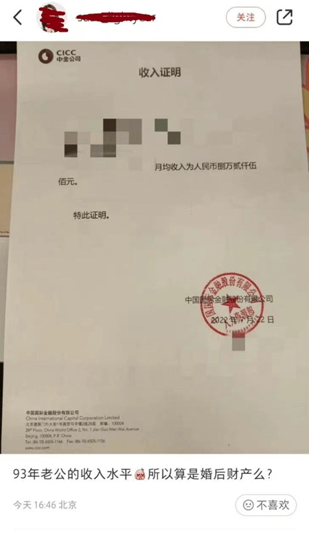
The monthly income of 80,000 Zhongjin has been suspended. Can the securities industry be controlled at a high salary?
The storm of Zhou Xuan Xuan wealth has not yet calmed down.Recently, the wife of a...
Foreign Exchange Bureau: In May, the bank's exchange and sales surplus surplus of 9.7 billion yuan
Zhongxin Jingwei, June 15th. On the 15th news on the website of the State Administration of Foreign Exchange, statistics from the State Administration of Foreign Exchange show that in May 2022, bank f