Nature: Mountain -band terrain controlled by flowing nature and surface process
Author:Institute of Geological Earth Time:2022.08.11


In the background of the collision background, the evolution of the mountain zone is composed of the crustal thickening, the surface raising, and the subsequent constructing silence and the crustal balance rebound link. The thickness of the crust enables the terrain of the collision -making belt, and the surface process (such as the erosion of the base rock of the river bed) reduces the terrain, which offsets the rising effect of the construction activity on the mountain belt. These two processes also connect the climate and structure of the structure at the same time. Get up (Whipple et al., 1999). There are large, small, high and low mountain belts on the earth. What factors are the factor that controls the width, height, and duration of the mountain belt? In addition, some activities have a high corrosion rate, but why can we maintain a high terrain of up to millions of years? These problems have been puzzling.
The end element types of the collision -making belt mainly include: (1) the narrow activity of high -lifting rate and high erosion rate, such as Taiwan and New Zealand southern Alps; (2) low erosion rate, forming a wide -seater, making mountains, such as Himalayas, such as Himalayas -The Qinghai -Tibet Plateau and Andes; (3) Unprecedented mountain belt, the terrain declines slowly, and can maintain dozens of to hundreds of millions of years, such as Mount Ural and Abbarachia. In the mountain zone without glaciers, rainfall and river erosion control the erosion rate, erosion rate and sedimentary ratio, implying that climate factor determines the height, width and surface fluctuations of the growth of the mountain. Life. However, there are other studies that in some cases, the limited crustal strength may be a factor restricting the biggest height of making mountain bands. We need a proper representation of constructing deformation to study the impact of erosion efficiency on the growth and decline of mountain belt. This character should include crustal balance, rock rim mantle dive, separated faults, and fluctuating degeneration close to the earth's nature.
Sebastian G. Wolf, the Department of Earth Sciences at the University of Bolgen, Norway, used a coupling model of a surface process and mantle scale structure to study the growth and decline of mountain bands. They used different end element modes and new outlines BM to quantify the surface process and how to control the evolution of the mountain belt, and thereby define the three types of growth mountain belts, as shown in Figure 1.
Type 1: BM> 0.5, unstable, controlled by the strength of the crust.
Type 2: BM40.4-0.5, stable flow, and controlled by the crust strength.
Type 3: BM <0.4, stable flow, but controlled by erosion.
Studies have found that the constructor is dominated by the Himalayan-Qinghai-Tibet Plateau and the Central Andes, and in Taiwan (probably type 2), the strong surface process balances the role of high convergence rate; The surface process is dominated. The decline of the mountain belt is determined by the erosion efficiency, which can be divided into two different stages (see Figure 2A). The relevant time scale and equilibrium rebound characteristics of each stage are different. The study provides a framework that can uniformly explain the height, shape, and life of the height, shape and life of the surface process and the strength of the rock ring.
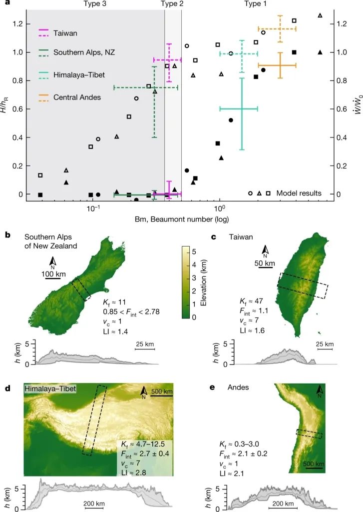
Figure 1 BM value of different mountains (wolf et al., 2022)
Use BM numbers to quantify the mountain belt
The author defines the new BM as the ratio of the countless outlines that have been used to connect the structure and the surface process. For growth mountain belts, BM is defined by the formula (1). Among them, the buoyancy generated by the increase in the mountain-made crust is related to the rejection deformation of the land-making belt, and the further width of the mountain belt; the rising-erosion number NE determines the relative importance between the erosion and the raising of the surface.

The number of BM provides a simple and unique description for the factors that affect the growth of the mountain belt, which linked the convergence speed, crustal strength, surface process efficiency, and other easily measured parameters (such as crustal thickness). Different models have different watershed erosion rates, sectors' movement speed and crustal strength. Their BM numbers are different, but the number of BMs of all models can be fitted as a curve (Figure 1A). Therefore, if you know the BM value of the active mountain belt, you can use the unknown parameters, such as the crustal strength and the average river erosion.
The BM value of the active mountain belt
The author summarizes the main control factors that determine the different types of mountain belt, as shown in Figure 1A, in an unstable type 1 (Himalayan-Qinghai-Tibet Plateau Creating), the impact of high aggregation rate is dominated by high corrosion rate; under similar erosion rates, similar erosion rates; If the aggregation rate is very low, it will form a mountain zone with a stable state, such as Sanz. For type 2, such as Taiwan's mountain belt, the extremely high erosion rate dominates. Due to the weak front land basin of the Taiwan Mountain Belt, it will also develop into a type 1 mountain belt at the high convergence rate. Different BM values on different mountain belts indicate that the strength gap between the crust on the earth is only between 2 and 3. The difference between the global sector convergence rate and river erosion can cross the larger level, and can determine the type of mountain belt.
Characteristic evolution characteristics
Comprehensive consideration of the interaction between convergence rate, crustal flow and surface process, can be evolved into 4 stages, as shown in Figure 2A.
In the first stage, the mountain zone began to grow (high) until it increased to the maximum high (HR) (type 1, 2), or a stable state (type 3) that reached the restriction of erosion.
In the second stage, for the type 2 and type 3 of the highland surface erosion rate, it grows stable with a fixed width; or when the local surface erosion cannot balance the structure of the structure, it will increase in an unstable state, resulting in a mountain zone of type 1 mountain zone belt Grow up at a fixed height. Under the influence of erosion, the decline of mountain -making terrain is controlled by erosion efficiency and equilibrium rebound. The third stage shows the rapid terrain decline and the removal of short -wave terrain.
In the fourth stage, the slow and long -term terrain decline is controlled by the surface rate and regional equilibrium rebound control.
Figure 2 The characteristics of different types of mountain zone evolution (wolf et al., 2022)

The research conclusion believes that the terrain evolution of the mountain zone is determined by the aggregation rate, the surface process efficiency, and the charm flow. The new BM number defines the three types of mountain belt, explains the hidden main control factors that form different mountain belts, and ensure that the intensity of the crustal strength and the average river erosion capacity is close to the real crust. In the crustal intensity, the mountain belt (type 1,2), the erosion efficiency may control the width of the mountain belt rather than the height, and the height of the mountain belt restricts the flow of the growing mountain belt. On the contrary, in the type 3 of the corrosion rate, the high erosion rate determines the height of the mountain belt, and ultimately forms a narrow -building mountain belt with a unique structure and a fixed width. Due to the unchanged erosion rate in the model, the time scale and speed of the decline of the mountain belt can be predicted through the number of BM, because the life of the mountain zone is dominated by the erosion efficiency. For example, Zhong Anders may exist for a long time, and it is likely to maintain longer than the Himalayan-Qinghai-Tibet Plateau; and Taiwan may be able to be paid in several millions of years during the construction of a static period.
main reference
Whipple k x, Kirby E, Brocklehurst S H. Geomorphic Limits to Climate-Induced Increases in Topographic Relief [J] .nature, 1999, 401 (6748). 39-43.
Wolf s g, huisMans r s, braun j, et al. Topography of mountain belts controlled by rheology and surwork projects [j] .nature, 2022: 516–521.
Writing: Li Shunzhi, Tian Xiaobo/Rock Circle

Beautiful editor: Chen Feifei
School pair: Wanpeng
- END -
Bionic AI can imitate human visual gaze ability, and in the future may check cancer

Science Fiction Network July 1st (Liu Yazhu) According to a study published in the...
Foreign media wind changes?At this section, what does "boast" Chinese chip mean?

Since my country's high -tech industry shows the rise of the rise, the United Stat...