Revealing Shenzhen in the ancient Haitu
Author:Yangcheng Evening News Yangche Time:2022.06.23
Text/Yangcheng Evening News reporter Li Tianjun
Figure/Yangcheng Evening News reporter Wang Lei
The first folk marine library in the country — Dapeng Peninsula Ocean Library collected books and video materials during the construction of the library. The curator Shen Xiaoming unexpectedly found 26 Haitu in the 16th century in a foreign library. "Lantao", "Lamto", or "Singan" geographical label! The geographical location is very consistent with Shenzhen. Shen Xiaoming has repeatedly verified that the above labels are Latin transliteration in the south and Xin'an. In the 16th century, Portuguese, Spanish, Dutch, did the Great Triangle Sailing fleet have reached the south? Why label "NANTOO" and "Singan" on Haitu? Why does Shenzhen navigation in modern times unknown in the world's navigation history? In Shenzhen, Nantouzhai during the Ming Dynasty, what kind of existence was in the minds of Dahanghai's mind? A reporter from Yangcheng Evening News walked into the Ocean Library of Dapeng Peninsula on June 16, exclusively revealed Shenzhen in the ancient sea map.

Dapeng Ocean Library Director Shen Xiaoming
The mysterious place name on the ancient European navigation map
An inconspicuous courtyard in Shenzhen Dapeng New District, claiming to be the first and the only folk marine library in the country, is located here. The curator Shen Xiaoming received the reporter and his party.
Shen Xiaoming opened the salon and talked about Shenzhen in the era of great sailing. He told reporters that he accidentally discovered 26 Haitu in the 16th century to the 17th century in a foreign library. There were "Nantoo", "Lantao", "LAMTO", or "Singan". Latin translation.
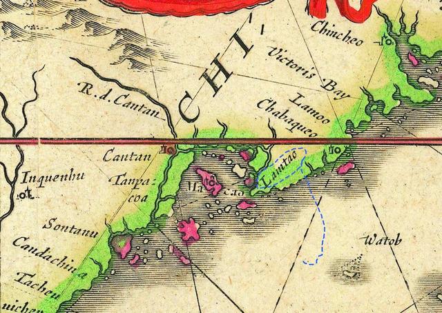
This is a map published in Amsterdam in 1642, indicating Lamtao in the picture
Why does "nantoo" and "Lantao" point to Shenzhen South? Shen Xiaoming told reporters: "I am more interested in the history of marine trading, and also pay attention to the Asian navigation of Portugal and Netherlands. Lamto was marked on the position of Shenzhen and Hong Kong. At that time, it was not considered to be the south, because the Hong Kong Lantau Island was called "Rotten Mountain" in Cantonese. In the late century, the map was marked with Singan (Xin'an), which made me more confirmed that the targets on these ancient maps were the predecessor of Shenzhen -Xin'an County. "
Shen Xiaoming pointed at a map and said that this was a map published in Antwerp in 1593. The charter was Gerard de Jode, an outstanding map producer in the late 16th century. On this map, the location of Shenzhen was marked as NANTO. Another map published in Amsterdam in 1642 is a world map produced by the Blaeu family of Amsterdam. It is clearly marked with Lamtao at the Zhujiangkou position (Cantonese pair of Cantonese). This is not an isolated case. The Italian mapmaster is marked with Namtoo at the same position. This shows that since the end of the Ming Dynasty, Shenzhen has always occupied an important position on the trade map of Western navigators.
Zeng set up a village to trace the land of the Pearl River on the ship
The reporter learned that there was an opinion on the academic circles that the academic circles were believed to be Hong Kong's Lantau Island. According to two -one is Lantau Island, which is also known as "Rotten Mountain", Cantonese pronunciation is also close to NANTO (LAMTO, Lartou); the second is based on Luo Mingjian's "Daming State" (the first Chinese atlas compiled by Europeans ) It is recorded that Lantau Island was marked as "Insula Namto".
Shen Xiaoming refuted this opinion, and he believed that there were three reasons. First, if it is Lantau Island, then NANTOO should be drawn as an island on the map, but these maps are marked on the mainland; second, Luo Mingjian's "Daming State Map" was written in 1606, but many maps he found were earlier than earlier than before At this time, it is not affected by Luo Mingjian; when many maps are produced, Nantouzhai on the Nanshan Peninsula has been established for some time. The drawer should be more willing to use a point with an administrative station as a map indicator point.

This is a map published in Antwerp in 1593. The picture is marked with NANTO (NANTO)
Liang Erping, director of the Marine Art Research Center of Shenzhen University and a famous Haitu researcher, highly agreed with Shen Xiaoming's inference. He said in an interview that historical materials can also prove Shen Xiaoming's speculation. According to historical records, the ancient city of Nantou was built in the 27th year of Ming Hongwu (1394) at the time. According to the "Records of the Mingwu Zong", the Portuguese must go through the Pearl River in the process of exploring Guangzhou, and first pass through the south.
In order to prevent the pirates from landing, the Ming government set up a position for the general soldiers in the south. In order to continue north sailing and requested the Ming government to allow business, on August 15, 1517, the fleet commander of Portugal Porte Portez and the south -headed general soldier of Portugal submitted the pro -document of the King of Portugal. After reporting its "basic purpose is to escort the king of Portugal to send the envoys of the Chinese king ... The ambassador to carry a good national book with Yongxiu and Good", Fernan and his party waited for two years in Guangzhou to enter Beijing. Go to Guangdong. Later, a naval battle in Tuen Mun was occurred. The deputy envoy of the Guangdong Needoidon led the Chinese Water Division to the Portuguese in the Tuen Mun Sea outside Nantou City, and the Portuguese defeated. There was an important position in the history of navigation gradually declined
Liang Erping believes that there is no problem with Shen Xiaoming's inference. It can be clearly said that "nantoo", "Lantao", "LAMTO", or "Singan" are south and Xin'an. Of course, this is not a new discovery, because Haitu has always been there, Shen Xiaoming can "out" Shenzhen in the big navigation era, and there is evidence, which is amazing. It is meaningful to re -understand Shenzhen's important role in marine trade and coastal fortress, and has a significant role in reshaping Shenzhen's position in the history of marine history.
Dr. Ma Lian, who has lived in Shenzhen for 27 years, is a post -doctoral scholar of Brown University, Ph.D. of the Department of Culture and Anthropology, Rice University. "Research. Since 1995, her research direction is the changes in Chinese cities since the reform and opening up, and she has a deep understanding of the changes in Shenzhen and the ancient Haitu.
Regarding Shen Xiaoming's trace of the European Haitu in the 17th century in the 17th century, she believes that the south (Xin'an) has been in the history of the Ming Dynasty to the beginning of the Qing Dynasty for a long time. The south head is indeed the only way to trace the Pearl River on the ship. However, because of the ignoring the ocean in the Qing Dynasty, the status of Baoan (Shenzhen) gradually declined. Because of the characteristics of ancient marine trade and the coast of the fleet, the south (Xin'an), which is the fortress of the coastal defense, is also a must for the Lingyuyang to enter the inland Pearl River and Guangzhou. It is very important to receive documents and obtain supply. Shen Xiaoming's very important page in the history of navigation (Xin'an) settled the dust and re -displayed it to the world.
Source | Yangcheng Evening News
Editor -in -law | Xu Jing
- END -
[Recommended Reading of Excellent Original Poems] Liu Yan Poetry Selection

The author profile Liu Yan, pen name Zhanlu, the police of Suzhou Public ...
One "Yan" is difficult to do | I only know "sunbathing" and "turn over"

Source | Jingbao APPCoordinating: Zhou XiaozhengFigure: He XiEdit: Zhou Xiaosheng