Don't worry about the broken plane!Landshists have great uses!
Author:Institute of Physics of the Ch Time:2022.06.18
Keke, the bad plane mentioned here is not a large wave of passengers in the sky.

Instead, there is such a mysterious and professional organization (Bushi), and their task is to try to try to fly a good aircraft.

This job is the aircraft test flight. The "organization" related units are the China Flying Test Research Institute (AVIC Testing Flight Center) for the test flight. The aircraft test flight refers to the test of the aircraft before forming the formation, grasping the degree of deformation, deformation limit, and conditions within the endable range of the aircraft, and conditional information such as limit speed and pressure within the tolerance range. Test flights are divided into three stages: engineering test flight, stereotype test flight, and weapon target test flight. Here we focus on the almost destructive test flight, that is, what conditions do he need to fly or bad? How to quantitatively determine to what extent it is "bad"?

The traditional method is to set the accumulated flight time according to the experienced pilot setting standards. After reaching a certain period of time, the wing needs to be replaced.
The deformation measurement is to compare the valid data such as the point height and coordinates before and after the deformation, and the degree of deformation of the observed object by measuring the changes in relevant data in different periods. Conventional measurement techniques include the observation method of the whole station, photography measurement method, three -dimensional laser scanning method, and BIM visual modeling method.
What is close -up photography measurement?
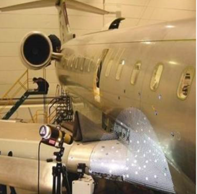
This photography is not another photography. Photography measurement refers to the use of the shape, size, and space location of the target to measure the target. Repeated shooting on the observed objects repeatedly, which will overlap the photos taken by different points of cameras. The points of the same position on different photos are called the same name point. Two -dimensional image information can be converted into a three -dimensional model.
(Like this bear)
The common line condition equation indicates that at the moment of photography, the projection center, the point, and the image are located on the same straight line:
Due to the three flats and four flats, there are differences in different measurement positions in different test flights. We divide the aircraft as a whole: the fuselage, the wing part, the tail part, and the power device part. This area division helps obtain data location information and subsequent image stitching through image judgment.
Three -dimensional coordinate information is obtained by obtaining some feature points on the fuselage, combined with three -dimensional laser scanning technology, and the relative position relationship between some feature points is obtained, so as to establish an independent coordinate system on the aircraft, combining the three -dimensional coordinate data of the ground with the aircraft coordinate system. After a series of show operations, the first -level control network for control points observation. The so -called characteristic point is a characteristic point (Feihua), and the aircraft surface color is single, lacking texture, (that is, there is no feature), and you need to post artificial signs in an important part of the wing and the body. Long like this so that the video collection process is automatically recognized and measured.
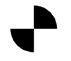
Spherical target
However, considering that the posting and removing the logo point are more time -consuming (tiring), the time of the voting point instrument is used to effectively reduce the artificial logo time, but a small number of feature points still need to meet the subsequent three -dimensional laser scanning coordinates collection and the needs of conversion. Essence
Pro-SPOT doter
What is a three -dimensional laser scanning?
The three -dimensional laser scanning is the oblique distance, horizontal angle, and vertical angle between the surface of the subject and the scanner through the scanner transmitting the laser measurement. It is the scanner and the space for the space of the measured point.
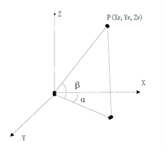
Scanner collection data space relative position coordinate system
XP = Scosβcosα
Yp = scosβsinα
Zp = scosβ
The handheld three -dimensional scanner, when scanning the aircraft, cooperate with the global photography measurement system to eliminate accuracy of cumulative errors. With multiple wire beam laser to obtain the surface of the object, the point information determines the space position of the scanner during the scanning process through the visual mark, and completes the three -dimensional point cloud overall restructuring on the surface of the object surface. Since the project involves confidentiality issues (┓ (´∀`) ┏), a small aircraft model simulates the surface modeling process of the aircraft, and the data containing point information is performed visually. It can be intuitively and accurately known. Under certain conditions, which part is easier to break, or to what extent to which the fuselage is caught under the limit or pressure.
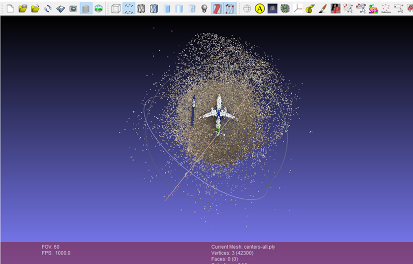
Photography measurement of MeshLAB model modeling diagram
In this way, we fully understand the process of aircraft test flight from the degree of measurement destruction to visualization. Due to length, the conversion of different coordinate axes and the work of error analysis did not unfold. The aircraft test flight project is an important guarantee to ensure the safety of aircraft flight and is an important part of the national aerospace field. It can be seen that as an important basic discipline, it is shining and glowing in various important areas.
Reprinted content only represents the author's point of view
Does not represent the position of the Institute of Physics of the Chinese Academy of Sciences
If you need to reprint, please contact the original public account
Source: Stone Popular Science Studio
Edit: lychee jelly
- END -
US media: In order to "brush the existence", Ukraine plans to be destroyed by the Russian tank in the European tour

According to Bloomberg reported on June 20, Ukraine is planning to exhibit the des...
"Model Red One Company": "Cloud Teaching Class" Burning Education Fire

Author | Han Shenghu, Sun QianzhaoPhotography | Sui YanYongzhou is an important pl...