Against the sizes, the reporter of Dahao Heshan walks into Pinghu's surveying characteristic school
Author:Zhejiang Daily Time:2022.06.28
Zhejiang News Client reporter Xiao Weile Correspondent Wang Xian Gu Qiuye
How is the height of the world's highest peak Mount Everest? What do you want to do first in the city? Entering Xinzheng Central Elementary School in Pinghu City, many children will tell you the answer -surveying and mapping.
Xinya Central Elementary School is a rural primary school. Nature children can know the professional terms in universities, thanks to the science education of geographical information of surveying and mapping. In 2016, under the joint guidance of the natural resource planning department and the education department of Pinghu City, the school began to create a special course for education. After that, it was even more of the landscape measurement symbols and created a characteristic school in the province. In February this year, the school was identified as "2021-2025 National Surveying and Mapping Geographical Information Science Popularization Education Base", which is the only elementary school in the country to be identified.
How do children learn surveying and mapping? What kind of touches can surveying and mapping to children? Recently, veterans Zhu Haizhong brought a sand table production lesson to the children. We also came to this school and became a "intercourse" to learn surveying and mapping with the children.
Veterans enter the classroom
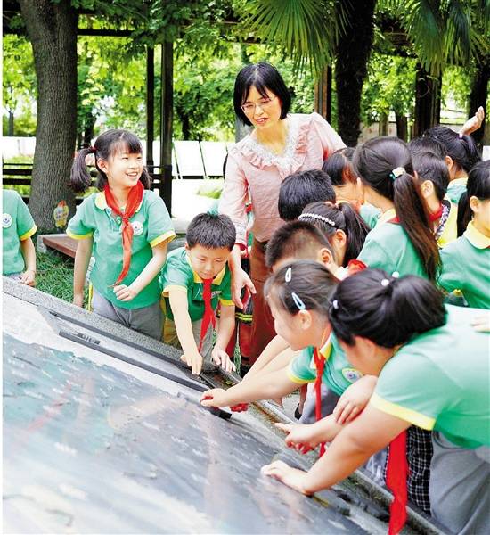
At 1:30 pm, accompanied by Wang Ting, a staff member of the Natural Resources and Planning Bureau of Pinghu City, Zhu Haizhong, an off -campus counselor, walked into the school's laboratory. Inquiring with the school's vice president Zhou Hongming, he learned that in 2016, the school formed a team of 15 -person science popularization volunteers, and invited Wang Ting and Zhu Haizhong to serve as "off -campus counselors". In this lesson, Zhu Haizhong will teach the island sand table for the fourth -year students.
Zhu Haizhong is a veteran who has been engaged in military sand table for a long time. "Pinghu is a county -level city in Zhejiang, located in the northeast of Zhejiang, and then to the east is the sea ..." From the geographical location of the sea facing the sea, back to Shanghai, it talks about the delicious seafood and unique watermelon lamp ... Zhu Haizhong The introduction of the children sighed from time to time. "It turns out, Pinghu is here!" "Wow, my hometown is great!"
After listening to Mr. Zhu's introduction, the students couldn't wait to see the "birth" of an island. "Does anyone want to try it?" Seeing that other students were still shy, we immediately raised our hands in the back row and "grabbed" in advance. Cut the uneven foam plates into "mountains". Looking at it simple, it is not easy to operate. After the force, the "mountain" is concave; if the force is small, the original "cliff" is still raised. After trying it several times, we made a gentle slope. "Professional sand tables must also be strictly followed by surveying data." Zhu Haizhong said that in order to make a mountain sand table, he and his comrades over the mountains over the mountains for several days, just to obtain accurate surveying and mapping data. Cutting, plastering, spraying green paint, and "mountain flowers" ... With the help of Zhu Haizhong, we finally "planted" a green island.
A question pulled the classmates back from "Dream Island". "If your home is on the island, what will you treat it?" Zhu Haizhong's words were caught in thought. Some people say that a bridge must be repaired to the island, so that it is no longer an isolated island; some people say that you need to install a few large windmills on the top of the mountain and use the sea breeze to generate electricity; … After the ringtone sounded, the students were still unhappy.

"It is not just a sand table, but also to guide children to pay attention to their hometown, and then love the motherland." Zhou Hongming said that in recent years, in order to increase the fun and vividness of teaching, the school also combined with the provincial Museum of Surveying and Mapping and Geographical Information Technology, Pinghu A number of units such as the Municipal Natural Resources and Planning Bureau have carried out more than ten surveying and mapping activities such as "small reviewers" and popular science carnival- "protecting measurement signs, guarding national territory", high -rise building sand table production. They all make children full.
"Pointing" in the trees
On campus, we heard cheers from a distance. Following the sound, we walked into a small garden called the "Landscape Measurement". I saw that a group of second -year children were surrounding the relief of the map of Chinese maps in the green trees, and they found the "home".
Class 202 classmates Huang Boya held high in hand. "Teacher, this map of China, I care about this place most." As he said, Huang Boya pointed at the box in the lower right corner of the map with his fingers. "Observe very carefully. This is the shrinking map of the islands of the South China Sea!" The teacher Zhang Fengling immediately added that our maps were horizontal and vertical, but China's territory and territorial sea must not be less at all.
"Do children know? In order to let the territory of our motherland have a lot of efforts on the map at all, the surveying and mapping staff has made a lot of efforts." Zhang Fengling shared the stories about the map with the children on the South China Sea Islands as an example.
After reading the map with the children, Zhang Fengling told everyone the history of Chinese surveying and mapping in a simple way. From the rules and regulations, to the Sinan Kazuka, to the modern aviation photography, navigation positioning ... walk all the way, walk all the way, follow the footsteps of the teacher, we touch Sinan portrayed on the ground. "Thousands of years" see the changes in China's territory.
"For low age, layout education is more intuitive. It can not only lay the foundation of surveying and mapping, but also cultivate patriotic consciousness." Zhou Hongming said that in order to allow surveying and mapping knowledge to enter more classrooms, every Monday afternoon set up a "layout mark" course course Every Friday class test, painting, preaching, knowledge competition, etc., and the school also compiled a set of school -based courses. According to this course, each grade can teach knowledge and organizational activities according to different regulations. Starting from surveying, the seeds of patriotism slowly take root in children's hearts. "Planting" stars on the playground
"Dingling Bell!" The ringtone rang at 2:25 pm, but the two boys hurried out of the teaching building. "My name is Fei Shuhao, his name is Pang Yueze. We are all members of the map mark. We are going to draw stars on the playground!" Yang Yang's paper was raised, and they took us straight to the playground. More than 20 classmates have been gathered on the playground. At their feet, there are not only tapes, color flags, but also several benchmarks.
"The" breeding "star is a regular mapping practical course for grades 5 or six, and it is also an interesting mathematical application question. It can just land the main point of knowledge." Said Xu Yanping, a scientific and technological counselor at the school. How big is this star? 50 meters in diameter. How to "plant"? A number of knowledge such as ruler rules and proportion applications need to be used. Under the guidance of Xu Yanping, we successfully drawn a standard five -pointed star pattern in a 10 cm 10 -centimeter square with the help of a straight ruler and round regulations, and the distance between the diagrams of each corner and the square four sides was calculated. "With these pictures, we can make the stars easily 'landing'." Xu Yanping said confidently.

10 minutes, 20 minutes ... With the measuring length of the tape measure, the students repeatedly measured correction with the direction of the guideline needle. Under the scorching sun, all of them were sweating. "What is tired of this, think about the national test brigade, that is called hard work!" Standing under the sun to guard the positioning benchmark, Fei Shuhao does not forget to tell us stories. He said that in order to give Mount Everest height, the National Testing Brigade climbed to Everest 6 times, and each time he carried a precision measurement equipment weighing 30 to 40 kilograms. Due to the severe hypoxia, some people almost sacrificed. "I hope I will grow up, and I can also be an excellent surveyor to walk through the land of the motherland." Fei Shuhao said.
"Reading thousands of books and thousands of miles, we hope to make children know how to cherish life and love the motherland through practice." Xu Yanping said that since 2016, the school and the natural resource planning department of Pinghu City will be used for each two to sixth grade students every two years. , Organize a group of students who are interested in surveying and mapping knowledge and strong hands -on ability, set up layout marks, and open different projects according to the characteristics of students.
The setting sun is sprinkled on the playground, and the pentagram of "painting" in color rope seems to be shining.
On June 28, "Zhejiang Daily" published the published version published

- END -
Lighting the fire of practice of youth interpretation
In order to warmly celebrate the 101st anniversary of the founding of the Communis...
682 points in the college entrance examination!He has been admitted to the juvenile class of the University of Science and Technology, and the school's notes are famous for all disciplines
Jimu Journalist Zhang YuCorrespondent Zhu JieHis notes in various disciplines are ...