Tonight rain is coming again!The risk of meteorological disasters in these places in Sichuan has increased greatly
Author:Chuanguan News Time:2022.07.21
Chuanguan News reporter Chen Ting
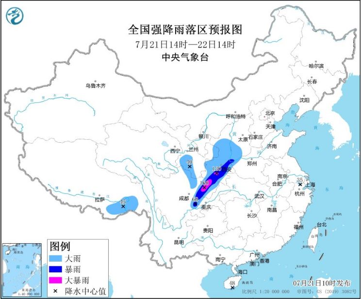
Central Meteorological Observatory continued to issue heavy rain blue warning at 10:00 on July 21:
It is expected that from 14:00 on July 21 to 14:00, there are heavy rain in southern Gansu, Shaanxi, southwestern Shanxi, eastern Sichuan, western Chongqing, and southeast of Tibet. Among them, southern Shaanxi, northeast Sichuan, etc. There are heavy rains (100-160 mm) in the local area. The above -mentioned areas are accompanied by short -term and heavy precipitation (the maximum hourly rainfall is 20-50 mm, and the local area can exceed 60 mm). There are strong convective weather such as thunderstorms and winds.
Notice! Intersection Intersection "Northeast Sichuan" was named again.
This detail is worthy of our attention.
You know, on July 18, the "northeast of Sichuan" appeared in the heavy rain warning, flood disaster meteorological warning, and geological disaster meteorological risk early warning issued by the Central Meteorological Observatory and other departments. Subsequently, the heavy rainfall followed, and Bazhong, Dazhou, Guang'an, Guangyuan, and Nanchong, located in the northeast of Sichuan, became the most concentrated area of precipitation.
According to monitoring of Sichuan Meteorological Observatory: 8:00 on July 18, 2022, 8 stations in the national meteorological station with a total precipitation of more than 50 mm in the province, all concentrated in the northeast of Sichuan, of which Pingchang exceeds 100 mm more than 100 mm. , Bazhong, Nanjiang, Tongjiang 90-100 mm.
Sichuan Meteorological Observatory predicts that a new round of heavy rainfall will come tonight.
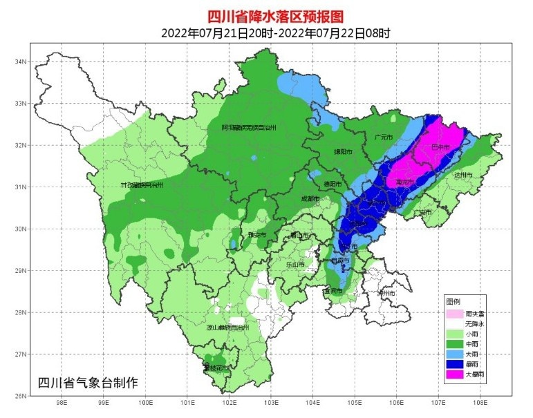
It is expected that today (July 21), there will be shower and thunderstorms in the cities in the Sichuan Basin. There will be a short -term gangue during thunderstorms, and there are medium rain in some places. There are heavy rains and heavy rain in parts of Mianyang and Guangyuan 4 cities, and local heavy rain; cloudy in the northwestern part of Ganzi Prefecture, cloudy or thunderstorms in other places in the remaining parts of the western Sichuan Plateau, with medium rain in some places, local heavy rain; Cloudy, showers or thunderstorms.
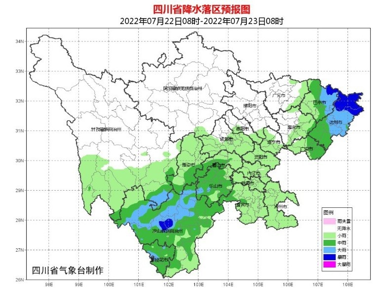
Tomorrow (July 22) During the day, the rain in the northeast of the basin will continue, but the rainfall intensity will weaken; the rain in the Panxi area will increase.
The Sichuan Meteorological Observatory predicts that most of the basins in the basin will turn cloudy tomorrow to night. There will be medium rain in the northeast and part of the southwestern part of the parts, and the local Sichuan Plateau will be cloudy and sunny. Cloudy, rain or thunderstorms, rain in the rain, and local heavy rain.
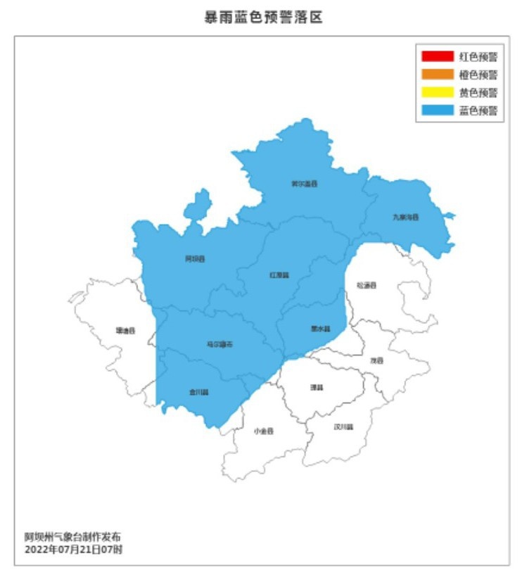
As of press time, Aba Prefecture and Nanchong Meteorological Observatory have issued heavy rain blue warnings-
▲ It is expected that from the afternoon to the night of this afternoon, there is an obvious process in the precipitation of Aba Prefecture. There are generally medium rain in the state. (Rainfall of 25-40 mm), some towns have more than 50 mm precipitation. When the process is coming, it will be accompanied by strong convective weather such as short -term heavy precipitation, lightning, hail, and gangsters. Relevant departments are requested to prevent the adverse effects of preventing heavy rain and strong flowing weather.
▲ It is expected that this evening to tomorrow morning, there is a thunderstorm in Nanchong City. There are generally heavy rain to heavy rain (40-80 mm). Among them, there are heavy rains (120-150 mm) in some towns in Yilong. , Lightning and Prearent Wind, the maximum hourly rainfall can reach 60-80 mm, and the gusts can reach level 5-7. Please strengthen the influence of meteorological secondary disasters such as mountain floods, flood floods, geological disasters, and urban waterlogging caused by the prevention of strong rainfall, as well as the adverse effects of lightning and wind and wind.

It is particularly worth mentioning that the Qujiang River Basin.
During the previous round of heavy precipitation weather, regional heavy rain appeared in the Qujiang Basin. According to the monitoring of Dazhou Meteorological Observatory, from July 18th to 16:00 on the 19th, a total of 144 stations in the city have accumulated more than 50 mm and more than 100 mm (mainly located in Dazhong) 11 stations. The rainfall Guanyin Shuangxi 43.1 mm. Cumulative rainfall in each urban area: Wanyuan 33.9, Xuanhan 34.6, Dawa 52.2, Kaijiang 17.5, Dazhu 77.9, Qu County 55.2 mm. At the same time, the upper reaches of Bazhong Pu had heavy rain to heavy rain. A total of 227 stations accumulated more than 50 mm, 90 stations exceeded 100 mm, and the maximum Tongjiang Chenhe was 189.6 mm.
★ Dazhou Meteorological Observatory reminded that the amount of rainfall in the Qujiang Basin this time is large, plus the weather drop from the evening of the 21st to the 22nd. Check.
After Jiuqing, we will welcomes heavy rain, which will greatly increase the risk of meteorological disasters in related areas. The Sichuan Meteorological Observatory reminds that the rainfall of the northeast of the basin and the south of the Sichuan Plateau is large, and it is necessary to prevent meteorological geological disasters such as land landslides, mudslides, and floods.
From yesterday to today, the temperature of the Sichuan basin rose significantly. With the arrival of this new wave of rain, Tomorrow, Sichuan will also usher in another cool day. At present, it is Sanfu Tian. In this day, everyone lives and cherish it ~

- END -
Grassroots "micro -preaching" blowing up "clean wind"

Grassroots micro -preaching blowing up clean windLi Zhaozhi Zhang LiliAs a member ...
What is the summer of the people's Daily Viewing White 丨 What is the summer?

Up to now, Jilin Province has built 54 ski resorts and 279 snow trails, with a max...