"Ocean Forecast" | Differences and feature analysis of the differences in different paths in the northwest Pacific tropical cyclone
Author:National Ocean Forecasting Tai Time:2022.07.26

Analysis of the differences and characteristics of the difference in different paths in the northwest Pacific tropical cyclone
Please use the PC terminal download address:
http://www.hyyb.org.cn/magazine/show.aspx?id=3400
Note
Author: Zhong Jian Zhou Qing Gu Shen Dan Wang Liqun Sun Yimei Han Miao Miao
Unit: China Satellite Maritime Surveying and Control Department, Jiangsu Jiangyin 214431
Category Number: P444
Publishing Year · Volume · Period (page number): 2022 · 39 · III (37-46)
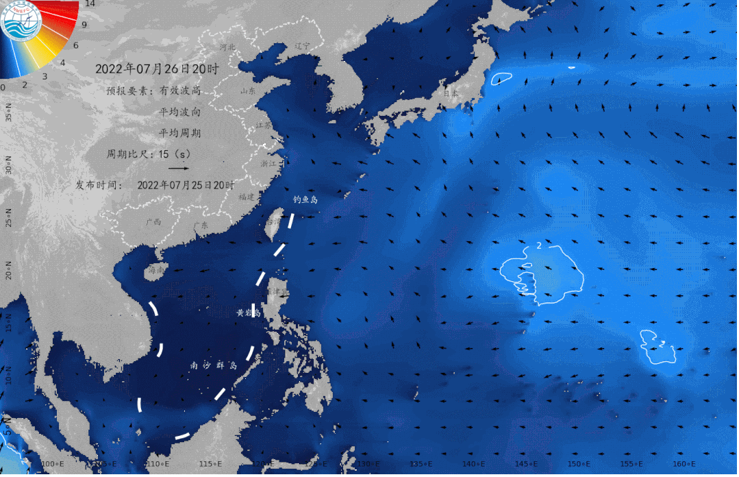
Summary: Utilizing the best path information of the China Meteorological Bureau (CMA), the Japanese Meteorological Agency (JMA) and the United States United Typhoon Alert Center (JTWC) from 1951 to 2017 Essence The results show that for tropical cyclone generation positions, from January to August, the latitude was gradually lifted north, and gradually moved south to December to April of the following year. Cross -cyclone generation; the earlier latitude of the earliest tropical cyclone each year was the smallest in March, and the month to July increased with the month. Tropical cyclone generation time (comparison of two or two data) is generally the smallest difference between JMA-CMA (the most related coefficient) and the maximum JMA-JTWC (the minimum related coefficient); The average monthly differences are maintained near the overall average value, and the difference between the non -active winter month is large. Tropical cyclone generation (comparison of two or two data) is generally the probability of JMA≤CMA and JMA≤JTWC, CMA≤JTWC; the average annual average exists (JMA & CMA, JMA = JTWC and CMA = JTWC). Small and stable in a certain range of the year, the other two situations show the trend of changes and obvious interpretation characteristics of the other year; the probability of the JMA Keywords: tropical cyclone generation; Northwest Pacific; statistical analysis Abstract: Using the best track data of the China Meteorological Administration(CMA), the Japan Meteorology Agency(JMA) and the Joint Typhoon Warning Center(JTWC) of the United States from 1951 to 2017, the characteristics of the tropical cyclogenesis(TCG) in the northwest Pacific and the difference among different datasets are studied in this paper. The results of the statistical analysis show that the location of TCG gradually moves northward from January to August, and gradually moves southward from September to December. Few tropical cyclone(TC) generates in the South China Sea from December to April and in the sea area east of 170°E from February to June. The average latitude of the first TCG is the lowest in March, and increases from March to July. For the time of TCG, the overall difference is the smallest(correlation coefficient is the largest) between JMA and CMA, and is the largest(correlation coefficient is the smallest) between JMA and JTWC. The difference of annual average shows a li near decrease trend. The monthly average differences show small variation in summer and autumn of the TC active season, while there is large variation in winter and spring of the TC inactive season. For the ratio of TCs that generated earlier or later, the overall possibility is greater for JMA less or equal to CMA, JMA less or equal to JTWC, CMA less or equal to JTWC. The annual variation shows a small and sustainable possibility for the situations of JMA greater than CMA, JMA equal to JTWC and CMA equal to JTWC, While The Other Two Situations of Each DataSet Show Characteristics of See-Saw and Inter-Decadal Variation. The monthly variation shows that the probability of JMA less than CMA and JMA less than JTWC is greater in most months, and the probability of CMA less than JTWC is greater from May to October.Key words:tropical cyclogenesis; northwest Pacific; statistical analysis Readers can also pass the public account menu bar The "Related Knowledge" sector enters the "current Catalog" and "Publishing Browse" Check the detailed journal content The marine environment forecast in the next two days Expected tomorrow, There are light waves from 0.9 to 1.4 meters in the Bohai Sea; There are light waves from 0.6 to 1 meter in the north of the Yellow Sea; There are light waves from 1 to 1.4 meters in the south of the Yellow Sea and north of the East China Sea; There are light waves of 0.8 to 1.1 meters near the waters of the south of the East China Sea and the Diaoyu Islands; The Taiwan Strait has a light wave of 0.5 to 0.7 meters; There are light waves of 0.9 to 1.1 meters in Taiwan on the east side of Taiwan; There are light waves of 0.7 to 0.9 meters in the bus strait and Beibu Gulf; There are small waves from 0.3 to 0.6 meters in the South China Sea to light waves. Expected the day after tomorrow, There is no big wave area in my country. July 26-30 Northwest Pacific wave numerical forecasting map Beautiful island waters sea conditions Expected tomorrow, The waters near the beautiful islands in my country are light waves, and the sea conditions are good. It is very suitable for traveling and island. Beautiful island refers to the following 35 islands: Juehua Island, Changshan Islands, Bodhi Island, Long Island, Liu Gong Island, Lingshan Island, Qinshan Island, Lianjima, Chongming Island, Shengsi Islands, Sushan Island, Dongji Island, Putuo Mountain, Dachen Island, Yuhuan Island, Dongdong Tou Island, Nanji Island, Laoshan Island, Sandu Island, Pingtan Island, Meizhou Island, Dongshan Island, Diaoyu Island, South Australia Islands, Wanshan Islands, Sichuan Shan Islands, Hailing Island, South Island, Dong Island, Dong Island, Dong Island, Dong Island, Dong Island, Dong Island, Dong Island, Dong Island, Dong Island, Dong Island, Dong Island, Dong Island, Dong Island, Dong Island, Dong Island, Dong Island, Dong Island, Dong Island, Dong Island, Dong Island, Dong Island, Dong Island, Dong Island, Dong Island, Dong Island, Dong Island, Dong Island, Dong Island, Dong Island, Dong Island, Dong Island, Dong Island, Dong Island, Dong Island, Dong Island, Dong Island, Dong Island, Dong Island, Dong Island, Dong Island, Dong Island, Dong Island, Dong Island, Dong Island, Dong Island, Dong Island, Dong Island, Dong Island, Dong Island, East Island, East Island, East Island, Dong Island Dazhou Island, Boundary Island, Wuzhizhou Island, Yongxing Island, Huangyan Island, Yongshu Reef. More coastal tourism forecasts are all in China's marine forecast PC can log in to China Ocean Forecast Network http://www.oceanguide.org.cn/indexhome The mobile terminal can use China Ocean Forecast WeChat Mini Program Click the picture below Enter "China Ocean Forecast" WeChat Mini Program Long press the picture below to identify the QR code - END -

Huang Cancan is waiting for you!Hohhot's rapeseed flowers bloom in the sea ...
The Dahei River is the first -level tributary of the Yellow River, of which the ri...
Guojiao to Dawangqiao to achieve continuous cycling

After the renovation of Nanfu Road, Jianguo Road, motor vehicles, buses, and non -...