Typhoon "Sanda" affects Shencheng on weekends. What "small personality" does it have?
Author:Report Time:2022.07.29
The impact of "Sanda" on Shanghai: Weekend wind blows on weekends, "there is one without one match", and the cooling is weak.
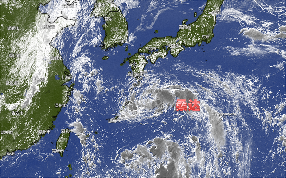
As soon as he was sent away at high temperature, the typhoon appeared. According to the data released by the Shanghai Central Meteorological Observatory, Typhoon Sanda No. 5 this year has been generated yesterday (28th) in the evening of yesterday (28th). ) From the night to the day after tomorrow (31st), wandering in the eastern waters of Shanghai during the day, which has a storm impact on Shencheng.
Today, Dongfeng, which came from the sea, sent a long -lost "crystal sky" to Shencheng. But behind the beautiful "cotton clouds", typhoons are "moving."
According to the data released by the Shanghai Central Meteorological Observatory, at 17:00 tonight, the "Sanda" is about 970 kilometers from the direction of the south of Jiangsu Qi Dongdong. The north direction moves rapidly, and the intensity does not change much. It will wander less in the eastern waters of Shanghai tomorrow night to the day after day. After the evening, the intensity will gradually weaken, and the intensity will gradually weaken and eventually tend to the Korean Peninsula.
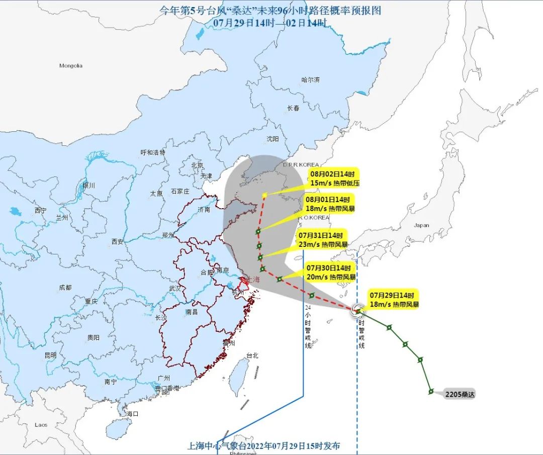
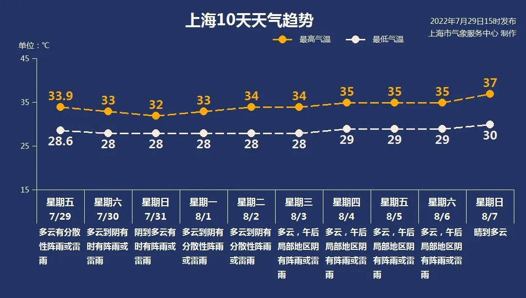
Affected by it, there will be a strong wind and rainfall process two days after the city. Specifically, there will be shower or thunderstorms in the city during the day to tomorrow night, but the rainfall distribution is uneven, and the local rainfall can reach heavy rain. From noon tomorrow, the wind will start to increase, the gust of wind is 5 to 6, and the maximum wind will appear in the day after tomorrow. The maximum gust of inland gusts can reach level 6 to 8, rivers and lakes and 7 to 9 areas along the coastal areas, 8 to 9 in the east of the Yangtze River Estuary District and Yangshan Port District, and 8 to 10 coastal seas of Shanghai.
So, compared with other typhoon, what is the "Sanda" personality of this visit? According to experts from the Shanghai Central Meteorological Observatory, the "Sanda" has a medium size, the intensity is not strong. Under this characteristic, the impact of "Sanda" on Shanghai is mainly the wind blowing, and concentrated on the weekend two days; showers are mainly mormonal precipitation. There are one without one. " In addition, the cooling effect of "Sanda" is also very weak. The highest temperature on the weekend is about 33 ° C, and due to the high humidity and the decreased air pressure, the body feel is still sultry.
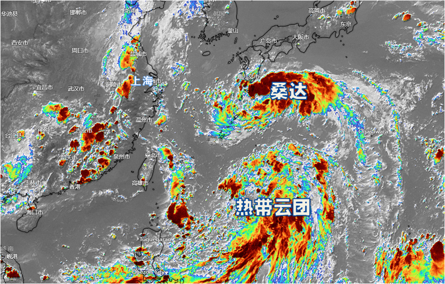
It is worth noting that the future trend of "Sanda" is still likely to "change hexagrams". Meteorological experts said that there are other tropical cloud groups on the south side of the "Sanda". Whether the two will interact in the later period, or even merge, have to pay more attention.
In addition, the Office of the Municipal Flood Control Headquarters issued a job prompt yesterday. In response to the characteristics of the long -term influence of this strong wind, reminding the flood control, water, housing construction, transportation and other departments at all levels to strengthen the billboards, air -conditioning outside machines, stores and stores, etc. Inspection and inspection; the management committees of the coastal areas, the management committee of the Lingang New Trip in Hong Kong, and the maritime affairs departments shall strengthen the management of the docks, ports, maritime operating ships, and sea pond operations to implement various windproof measures. If the port has been sheltered, the port management unit shall strengthen the port facilities to prevent the ship's anchor, stranding and collision.
Author: Zhang Tianchi
Edit: Zhang Yan
Editor in charge: Rongbing
*Wenhui exclusive manuscript, please indicate the source for reprinting.
- END -
Yitong Manchu Autonomous County Meteorological Bureau to lift the rain and blue warning [IV level/ge
At 5:51 on June 8th at 5:51 on June 8th, the Yitong Manchu Autonomous County Meteorological Bureau relieved the blue warning signal.
Lei Zhenglong: The amendment to the prevention and control plan is mainly based on 3 aspects of consideration

The State Council ’s joint control mechanism held a press conference on June 28. ...