"Sanda" will approach the coast of the northeast of Zhejiang to the southern part of Jiangsu
Author:Global Times Time:2022.07.29
Typhoon No. 5 this year's "Sanda" (tropical storm) center today (29th) at 5 pm is located on the northwest Pacific Ocean, which is about 970 kilometers south of Qi East, Jiangsu.
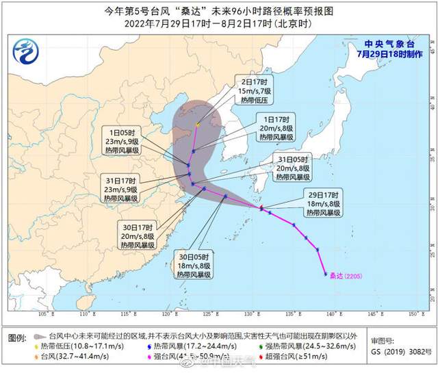
It is expected that "Sanda" will move north to north at a speed of about 40 kilometers per hour. It is about to move into the northeast of the East China Sea tonight, and then gradually approach the coast of northeast Zhejiang to the southern part of Jiangsu.Slow, and in the north of Jiangsu, the intensity has not changed much.

Dafeng forecast: 20:00 on July 29th to 20:00, the northern part of the East China Sea, the south of the Yellow Sea, Hangzhou Bay, the Yangtze River Estuary District, the coast of the northeast of Zhejiang, the coast of Shanghai, and the southern coast of Jiangsu will have 6-7 winds. "Sanda"The wind on the nearby sea of the center has 8 levels, and the gusts can reach level 9-10.(China Weather)
- END -
Gong Hongming: Sichuan Industry seeks innovation in development and breakthrough in innovation

From Beijing to Sichuan, from north to south, spanning thousands of miles, Gong Ho...
The sun is still the \"protagonist\", and the temperature is \"enthusiastic\"
Three -day forecast in Wuhan City Today: Day Cloudy Tonight: Cloudy ] Maximum temperature: 34 ° C, minimum temperature: 25 ° C humidity: 50-90 %, wind: east wind 3 Central urba