Take the "Huahai Line" together!Xiamen Shanhai Health Trail is going to be new again!
Author:Xiamen Daily Time:2022.06.16
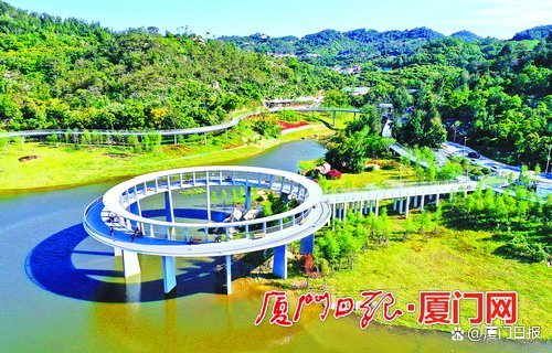
△ Xiamen Mountain Sea Health Trail Linhai Line First Phase Dongshan Corridor. (Photo by Xiamen Daily reporter Wang Xieyun)
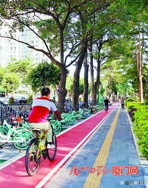
△ In recent years, our city has continued to improve slow -moving systems such as sidewalks and bicycle lanes in accordance with municipal facilities. (Photo by Xiamen Daily reporter Wu Haikui)
How is the construction of Xiamen City walking and bicycle lanes? How to improve the quality of citizens? What health trails will be built inside and outside the island? Yesterday morning, Wang Weijun, deputy secretary, deputy director and second -level inspector Wang Weijun of the Municipal Municipal Garden Bureau, was a guest network to introduce the construction of the city's slow line system.
今 The second quarter of this year is expected to be completed and open in the fourth quarter of this year
In recent years, the city has relied on resources such as mountains, sea, and streams to vigorously carry out health trail construction. According to Wang Weijun, according to the natural conditions and functional positioning of different regions, the city focuses on creating three types of trails: Binhai Trail, Shanhai Trail, and Creek Trail. At present, the city's health trails have completed a mileage of about 210 kilometers.
The island has been built on the Xiamen Mountain Sea Health Trail Yunhai Line (East -West Healthy Trail) and the Linhai Line (north -south health trail). The construction of the second phase of the Linhai Line (Dongshan Reservoir-Huandao Road) is accelerating, with a total length of about 13 kilometers. It is expected to be completed and opened in the fourth quarter of this year.
In addition, this year's relevant departments in our city are actively promoting the early planning of the "Huahai Line". The "Huahai Line" starts from Huwei Mountain. The part along the line passes through the Meihai Ling (the Meihua Sea of the Triangle), and it is finally about 15 kilometers in length. aisle. There are residential communities and commercial land along the line, north and south to the northern area of the northern coastal, lakeside area, golden chart area, and Zengyu area. In the area and other areas, the population of Siming City is about 350,000, and the radiation area is about 11 square kilometers.
Outside the island, the construction of trails such as the Ma Ling Bay Trail, the third phase of the coastal romantic shoreline (Torch Bridge-Aoutou), the Lugou Creek Trail, and the enhancement of the coastal romantic shoreline (Xinglin Bridge-Xinyang Bridge) and other trails.
Wang Weijun said that our city will form a healthy trail structure of the "one rim, one area of corridors" around the shoreline of the island, Cai Jianda Mountain, Tianma Mountain, Meishan, Meishan, Meishan, Meishan, Meishan. By 2025, the city's total mileage is expected to reach 500 kilometers. Among them, the rim is the coastal trail; the area is the coastal trail outside the island; the multi -corridor is the landscape trail of the island and the nine major streams outside the island.
计 By 2025, it is expected to add 407 kilometers of a slow -moving system
Riding a bicycle sharing, going to the subway station or bus station to take the subway, take a bus ... such a green and low -carbon travel method is becoming more and more common in Xiamen.
During 2013-2018, the city's comprehensive construction and enhancement of 219 kilometers of bicycle lanes on the island, implementing 9 projects such as the public bicycle system of the Huanzhe Lake area and the Xianyue Road public bicycle system. Bicycle lanes and other bicycle lane projects such as bicycle lanes and coastal tourism romantic lines have gradually improved the bicycle lane with severe damage and unreasonable section settings.
How to make concessions and ride safer, comfortable and smooth? Wang Weijun said that the municipal garden department will combine the establishment of a model of civilized cities in the country to accelerate the recovery and improve the right of non -motorized lanes, the treatment points near the overpass, and the optimization of barrier -free facilities. Supporting construction, further "return to the people."
According to reports, at present, the Municipal Garden Bureau has improved the 11 congestion points of the 25 municipal roads, including Bailuzhou Road and Xiahe Road, and the municipal roads. Provide conditions for continuous cycling, the overall progress of the project is progressing, and construction is planned to be completed by the end of July.
In order to accelerate the improvement of the city's road slowing system, from 2022-2025, the municipal garden department plans to promote 73 existing road transformation and improvement system projects and 195 new road supporting system projects. Essence
步 The main channel of the ring -shaped health trail on the island
● Cloud Sea Line -East -West Health Trail (has been built)
● Forest and Sea Line -North -South Health Trail (the first phase has been completed, and the second phase is expected to be completed and open in the fourth quarter of this year)
● Flower Sea Line — starting from Huwei Mountain, passing through Meihai Ridge along the line, and finally Dongping Mountain (is actively promoting the preliminary planning work)
走 "One Ring Road and One Belt H multi -corridor" healthy trail structure
● One ring: coastal ring road trail
● One Belt: Outside the island coastal trail
● Multi -corridor: The mountain seascape trail of the island, the bank of the Jiuda Creek Rixi River outside the island, etc.
(Xiamen Daily reporter Wu Haikui)
- END -
Jiangsu introduced the three -year action plan for home care service capabilities, Nanjing Xishanqia

Recently, 12 departments such as the Jiangsu Provincial Department of Civil Affair...
There is a kind of peace of mind, calling the people of the people
The people of the people, the pioneer of the party.Whether it is a critical junctu...