Zhejiang issued a wave of blue alerts!Typhoon "Sanda" moves into the East China Sea, these places will be affected
Author:Voice of Zhejiang Time:2022.07.30
not
Source: Comprehensive Zhejiang Voice Reporter Cai Jikang, Zhejiang Weather, Central Meteorological Observatory, Zhejiang News
The copyright belongs to the original author, if there is any infringement, please contact it in time
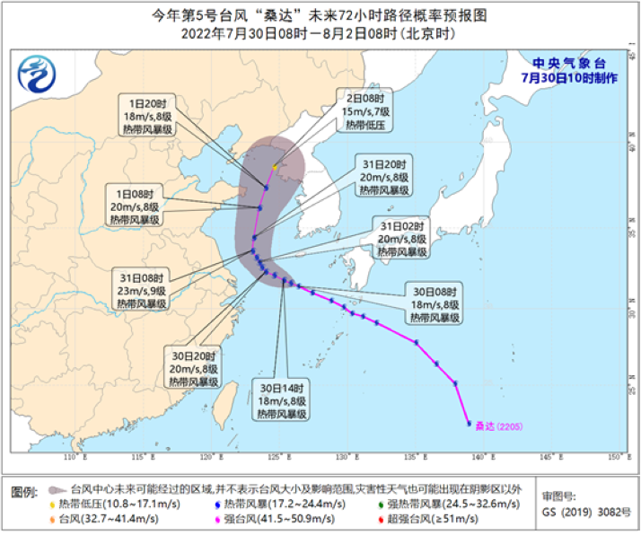
Central Meteorological Observatory at 10:00 on July 30th
Release typhoon blue warning:
Typhoon No. 5 this year's "Sanda" (tropical storm) center today (30th) is located on the northern sea of the East China Sea, about 450 kilometers east of Jiangsu Qi East at 8 am, which is 31.4 degrees north latitude and 126.4 degrees east longitude. The maximum wind nearby is 8 levels (18 meters/s), the lowest air pressure in the center is 1,000 hundred Pache, and the seven-level wind ring radius is 120-180 kilometers.
It is expected that "Sanda" will move north to north at a rate of about 20 kilometers per hour. The speed of movement on the 31st will slow down and go north in Jiangsu. The intensity has not changed much.
Dafeng forecast: From 14:00 on July 30th to 14:00 on 31st, the northern part of the East China Sea, the middle of the Yellow Sea and the south, the Yangtze River Estuary District, the coast of the northeast of Zhejiang, the coast of Shanghai, and the southern coast of Jiangsu will have 6-7 winds. The nearby sea surface passed by the center is 8-9, and the gusts can reach level 10.
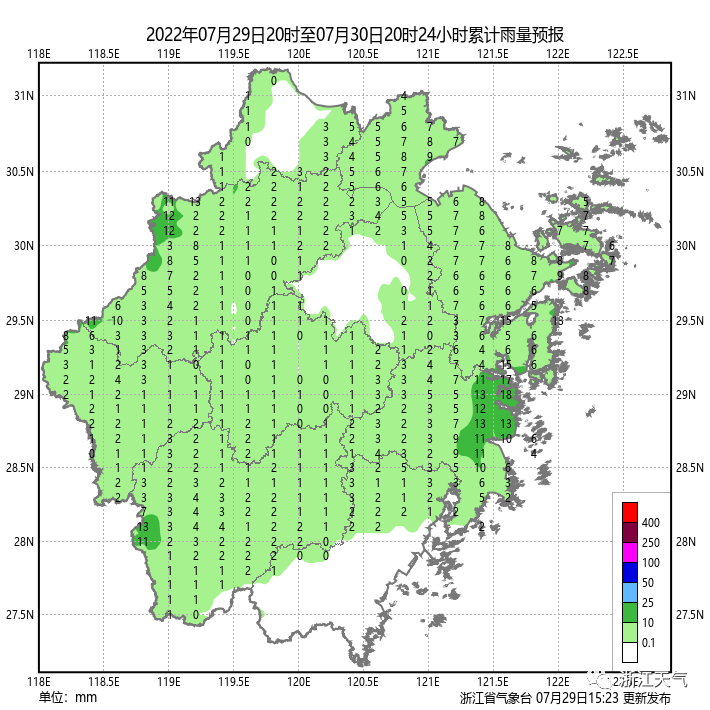
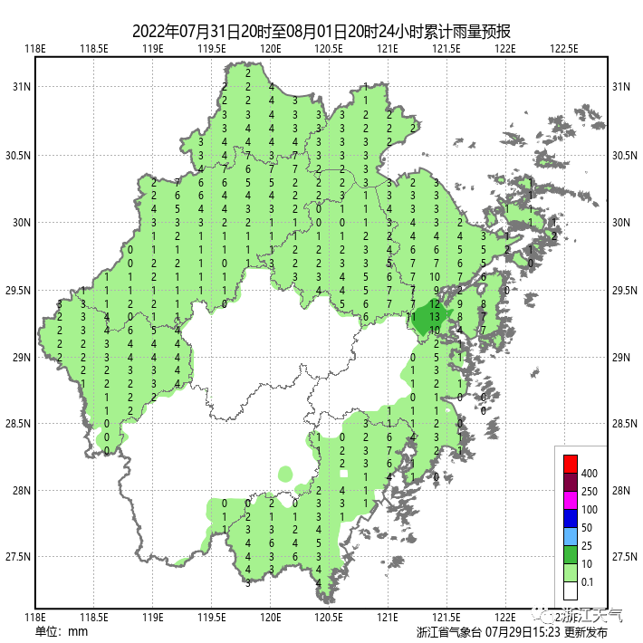
Precipitation forecast: From 14:00 on July 30th to 14:00 on 31st, there will be middle to heavy rain and territorial rainstorm in the southern coast of Jiangsu, the coast of northern Zhejiang, and Shanghai.
Defense guide:
1. We should continue to stay in a safe place to avoid the wind, and the dangerous house personnel will be transferred in time.
2. Related areas should pay attention to preventing mountain floods and geological disasters caused by precipitation.

Zhejiang Marine Monitoring Forecast Center
Release the blue warning
At 10:00 on July 30, the Zhejiang Ocean Monitoring and Forecast Center issued a blue alert.
Affected by Typhoon No. 5 "Sanda" (tropical storm), it is expected to be noon today to noon tomorrow:
(1) The sea area: Hangzhou Bay has a light wave of 0.5 meters to 1.0 meters, and it will increase to light to Zhonglang from 1.2 meters to 1.8 meters today. Increase to large waves from 3.0 meters to 4.0 meters; there are light to 1.8 meters to 1.8 meters in central Zhejiang, and the middle to 1.6 meters to 2.5 meters is increased today. Mi's light to Zhonglang increased to 1.4 meters to 2.2 meters in the middle of the night.
(2) Near -shore waters: Zhoushan is from 1.2 meters to 1.8 meters of light to Zhonglang, and this night increases to the middle to large waves from 1.8 meters to 2.8 meters. Near -shore sea wave early warning level is blue.
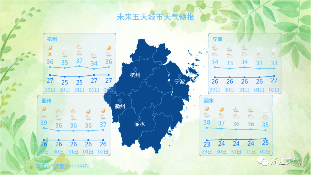
High temperature forecast
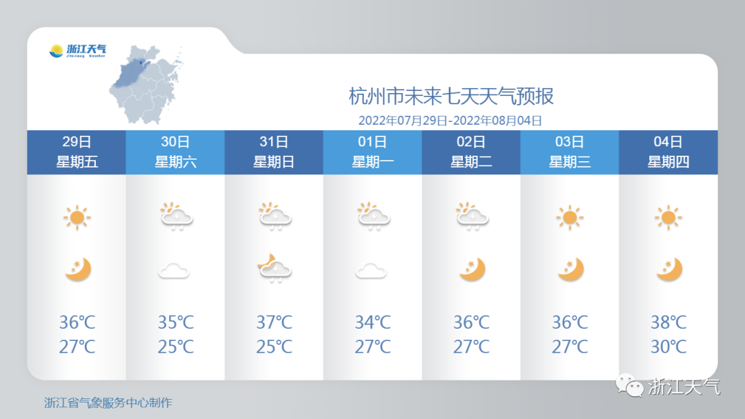
The Zhejiang Meteorological Observatory continued to release high -temperature reports today. Due to the control of the subtropical high -pressure control, there will still be a large range of high -temperature weather today in our province today. It is expected that today's maximum temperature in northern Zhejiang and coastal areas will be 34-37 ° C in other areas, 37-39 ° C in other areas, and local 40 ° C or more.
Today: The coastal areas are cloudy, and some shade has shower or thunderstorms; in other areas, it is sunny and cloudy, and there are decentralized thunderstorms in the afternoon. There are some short-term rainstorms in the thunderstorm areas above the thunderstorm area.
The high temperature will be strengthened from August 3, and the highest temperature in most areas in the province can reach 38 to 40 ° C.
Strong stream forecast
In the next few days, there are still many thunderstorms in our province. Among them, thunderstorms on July 30 are mainly in the coastal areas. On the 31st, in northern Zhejiang and coastal areas, on August 2-3, in the coast and southern Zhejiang region, the local part of the thunderstorm is accompanied by 8 ~ Level 10 Land 11 or above thunderstorms and short -term heavy rain and other strong convection weather.
In the process of strong convection weather, everyone should try to avoid going out indoors to ensure their own safety.

- END -
Latest notice: 53 asymptomatic infections in Xiahe, Gannan are related to this hotel

On July 18th, the News Office of the Xiahe County People's Government held the thi...
National Health and Health Commission: yesterday added local 75+310
At 0-24:00 on July 2, 31 provinces (autonomous regions, municipalities) and Xinjiang Production and Construction Corps reported 104 newly confirmed cases. Among them, 29 cases were entered overseas (8