Quanzhou's high temperature "arrogant flames" have converged!In August, there were two or three typhoon affected Fujian
Author:Quanzhou Evening News Time:2022.07.31

recent
A large wave of sauna weather
Affects the southern region
"Jiangsu, Zhejiang and Shanghai" has become a "worker"
Fujian people have become "confused"

good news
Fujian is about to withdraw from the "high temperature group chat"
As of 17:00 today
Most counties and cities in Fujian Province
The highest temperature is 35 ~ 39 ℃
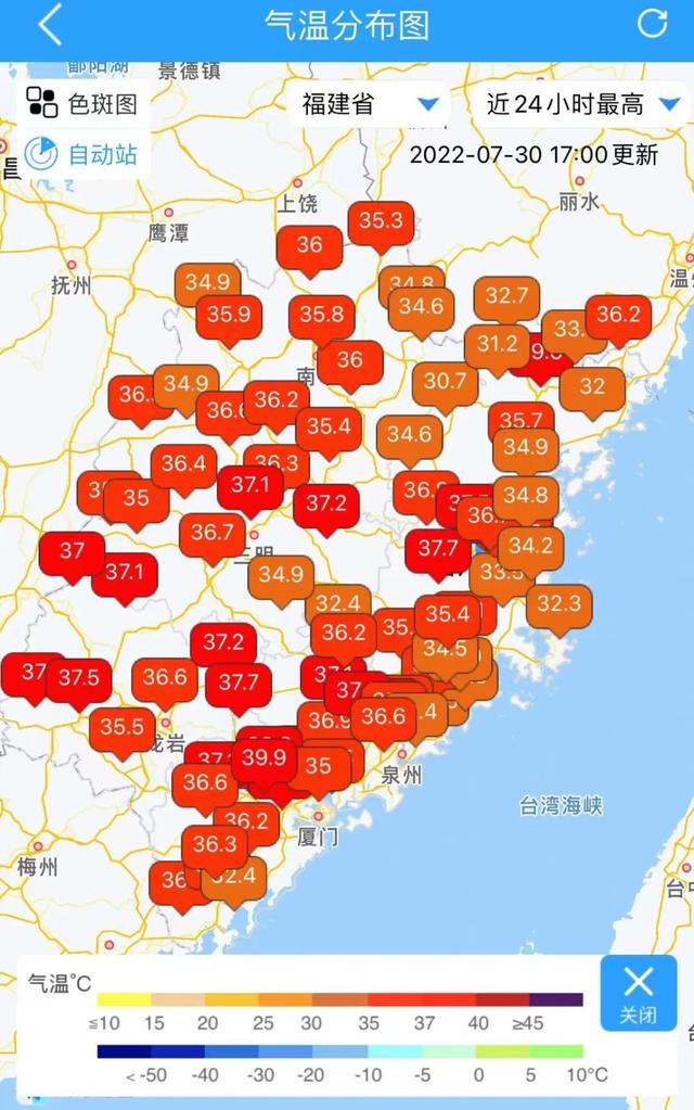
The Fujian Meteorological Observatory released the high temperature forecast of Fujian Province at 17:00 on the 30th:
On the 31st, the highest temperature in most counties and cities in Fujian Province can reach more than 35 ° C. ℃, local can reach 39 ℃.

As the subtropical high pressure continues to weaken
Some areas in Fujian Province will withdraw from the "high temperature group chat" one after another
The highest temperature is expected to fall below 35 ° C
The Meteorological Department of Fujian Province predicts that the climate trend of the province in August believes that the average temperature in the province in August is 0.1 ° C ~ 1 ° C, and the extreme maximum temperature is slightly higher. Among them, inland areas are 37.5 ° C ~ 39.5 ° C, 37 coastal areas 37 ° C ~ 39 ° C, the high temperature day greater than 35 ° C is close to perennial year. The high temperature process in August was roughly from 11th to 15th, 23rd to 27th.
In the afternoon, there is an increase in the probability of strong convection weather in the afternoon
According to the monitoring of the meteorological department, the "deputy high" will decline in the future. In the next few days, the "deputy high" forces in Fujian Province will be limited. Staged in various places, so everyone still has to pay attention to weather changes, heatstroke, sun protection and strong counterparts.
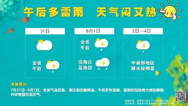
The weather is sunny to cloudy this weekend
However, there are still decentralized showers or thunderstorms in the afternoon
There are heavy rain to heavy rain
And accompanied by a short -term heavy precipitation,
Level 8-10 Thunderstorm Breeze
Or strong convection weather such as hail
Friends pay attention to thunderstorms
The adverse effect on outdoor activities
Please avoid thunderstorms during travel, pay attention to safety
The Meteorological Department of Fujian Province reminded that with the influence of tropical low pressure next week, from August 2nd to 4th, most of the provinces have shower or thunderstorms, and the precipitation in central and southern Fujian is more obvious.
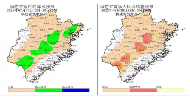
August or 2 to 3 typhoon affects Fujian Province
The Meteorological Department of Fujian Province predicts that in August or two to 3 typhoons affect Fujian Province.
It is expected that there are two or three typhoons that affect or land in Fujian in August. The influence period is in the middle and late and at the end of the month, and the average precipitation of the province is 20 % to 50 % in August.
Typhoon "Sanda" latest news
↓
Typhoon Sanda No. 5 this year
On the evening of the 28th, it was generated on the ocean
Typhoon enters East China today
And gradually turn to move north
There is no direct impact on Fujian in the future
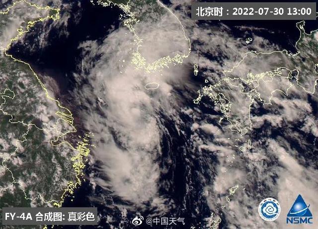
At 15:99 today, the Central Meteorological Observatory released a typhoon newsletter
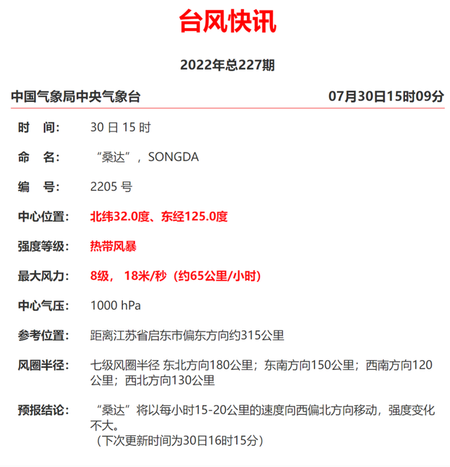
The Central Meteorological Observatory issued a typhoon blue warning at 10:00 on July 30
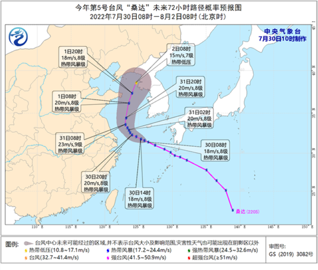
Typhoon No. 5 this year's "Sanda" (tropical storm) center today (30th) is located on the northern sea of the East China Sea, about 450 kilometers east of Jiangsu Qi East at 8 am, which is 31.4 degrees north latitude and 126.4 degrees east longitude. The maximum wind nearby is 8 levels (18 meters/s), the lowest air pressure in the center is 1,000 hundred Pache, and the seven-level wind ring radius is 120-180 kilometers. It is expected that "Sanda" will move north to north at a rate of about 20 kilometers per hour. The speed of movement on the 31st will slow down and go north in Jiangsu. The intensity has not changed much.
After high temperature steaming,
"Boiling water" in some areas pouring down,
Subtral high pressure retreat to the sea,
Typhoon "Sanda" undertakes the task of sending coolness.
Due to the weakening of the deputy height, the "arrogant flames" of Quanzhou's high temperature in the past two days have a little convergence compared to some time ago, but after all, the hottest "middle fu" of the year is the power of the sun. The highest temperature in the afternoon is 33-36 ° C in most parts of the city, with the highest 39.4 ° C of Anxi Guanqiao Town, and the thermal value has not been discounted at all. It is expected that in the next three days, due to the influence of the south side of the vice -high south side, the weather stage in Quanzhou will still maintain a single cycle of "cloudy+afternoon thunderstorm". Because the precipitation cannot be stained with dew, the highest temperature is maintained at about 35 ° C, and the sweltering sensation is lingering. I will remind everyone that the work of preventing heat and cooling still cannot be relaxed. At the same time, remember to carry an umbrella with you. error.
- END -
Luojiang District Agricultural and Rural and Water Affairs Bureau issued the risk of mountain flood
The Luojiang District Agricultural and Rural Affairs Bureau issued the risk of mountain flood disasters at 08:35 on June 09, 2022: Blue warning: According to the forecast of rainfall value, it is expe
A set of posters will quickly view Hainan's economic operation in the first half of this year

July 19thIn the first half of 2022, the press conference of the economic operation...