The heavy rain is coming!The impact of the two typhoons, the impact on the South China Sea ...
Author:South China Sea Release Time:2022.08.01

July weather
In the early stage "water deep", later "hot"

In August, high temperature in the short term is expected to relieve
August 3-5
There will be a heavy rain to rain and precipitation process in the South China Sea
"Double Typhoon" generation
No effect on Guangdong
According to the Central Meteorological Observatory, on the morning of August 1st, there were two typhoon activities in the eastern waters of my country, namely Typhoon No. 5 "Sanda" and Typhoon No. 6 "Cuisi", both of which were tropical storm intensity.
At present, the paths of double typhoons are pointing north of the direction, and the intensity gradually weakens. Affected by it, there will be 6-7 winds in the middle and southern parts of the Yellow Sea. Level 8, gusts 9-10.
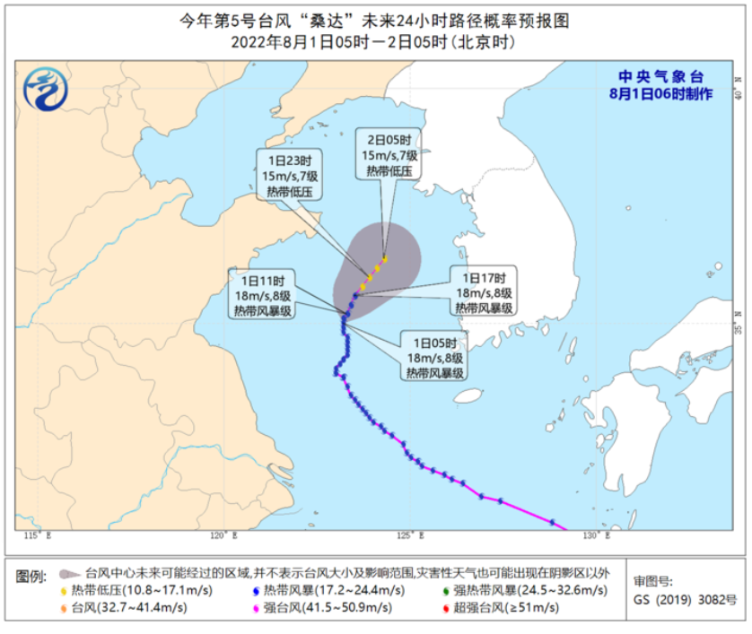
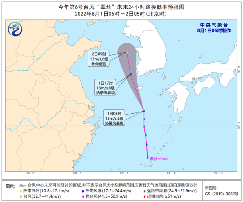
The Guangdong Provincial Meteorological Bureau predicts that Typhoon No. 5 "Sanda" and Typhoon No. 6 "Cuisi" have no impact on Guangdong.
Although Guangdong has not been affected by the latest typhoon, there is obvious east wind fluctuations in the southern part of the deputy high. The high temperature is obviously relieved.
High temperature is relieved
There will be a heavy rain to rain and precipitation process in the local area
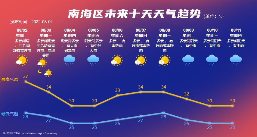
The South China Sea Meteorological Bureau predicts that on August 2nd, the South China Sea District is cloudy and sunny. There will be thunderstorms in the afternoon, the high temperature and hot weather will be maintained, and the highest temperature in the afternoon is about 37 ° C; August 3-5 is affected by the east storm. In the process, high temperature weather tends to relieve; on August 6-8, it is mainly cloudy. It can be seen that the sunlight, there are showers or thunderstorms. Looking forward to August 9-11, due to the new tropical disturbance, the rain has become obvious.
Specific weather forecast:
August 2nd: Cloudy and sunny, there are thunderstorms in the afternoon, 28 ~ 37 degrees, southwind 1 ~ 2;
August 3: Cloudy and cloudy days, thunderstorms in the afternoon, local heavy rain, 27 ~ 34 degrees, southeast wind level 2;
August 4th: cloudy is cloudy, there are heavy rain to heavy rain, 25 ~ 30 degrees, southeast wind level 3;
August 5th: cloudy is cloudy, there are middle to heavy rain, 25 ~ 30 degrees, southeast wind 2 ~ 3;
August 6: Cloudy, thunder showers, 26 ~ 33 degrees, southeast wind level 2;
August 7: Cloudy, there are showers or thunder showers, 27 ~ 34 degrees, southeast wind level 2;
August 8th: Cloudy, showing shower or thunderstorms, 28 ~ 34 degrees, southeast wind level 2;
August 9: Cloudy, cloudy, medium rain, 26 ~ 32 degrees, southeast wind 2 ~ 3;
August 10: Cloudy clouds, medium rain, 25 ~ 30 degrees, southeast wind 2 ~ 3;
August 11: Cloudy, cloudy, medium rain, 25 ~ 30 degrees, southeast wind level 2.
This wave of Guangdong is expected to be temporarily
Exit "High temperature group chat"
High temperature thunderstorm coexist in weather
Please pay close attention to meteorological dynamics when you go out

Follow the video number of the South China Sea, master the latest information of the South China Sea
- END -
[Twenty social practice exhibitions of youth gifts] School of Marine and Environment: Red Culture Leads Zhenxing Road to join the grassroots to help farmers

Recently, the teachers and students of the School of Marine and Environment, the S...
Keep life defense, anti -drowning tragedy!Changping District launched a special operation for anti -drowning

In the summer vacation, drowning is strictly guarded. Recently, Changping District...