The influence of "Sanda" is basically over!Shandong Ming will appear for 5 consecutive days of sultry "sauna" sky
Author:Rizhao News Network Time:2022.08.01

Shandong Meteorological Observatory
Today (August 1), a meteorological service fast report was released at 15:00
Express display
"Sanda" has basically ended in Shandong
August 2-6
Shandong will usher in high temperature weather that is sultry and rainy

"Sanda" has basically ended in Shandong

Typhoon Sanda No. 5 this year was weakened from tropical storm to tropical low pressure on the morning of the 1st. At 14 o'clock, the center was located on the sea about 230 kilometers south of Shandong Province. ), The maximum wind of 7 (16 meters/second) near the center, the lowest air pressure in the center is 1,000 hundred Pache. The intensity of "Sanda" will gradually weaken and gradually move to the Korean Peninsula.
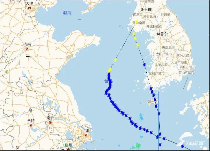
"Sanda" mobile path chart ("Sanda" on the left and "Cui Si" on the right)
Affected by "Sanda", from 00:00 on July 31 to 14:00 on August 1st, Weihai, Yantai, Qingdao, and Rizhao appeared to be small to the heavy rain in the rain, and Rongcheng Shima Port's precipitation was 48.8 mm.

From 00:00 on July 31 to 14:00 on August 1st
Northeast winds appear in the middle and northern waters of the Yellow Sea, and the gusts of offshore observation stations reached 6-8.
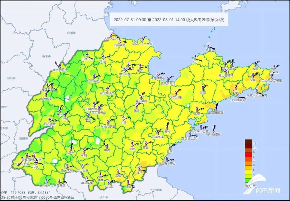
From 00:00 on July 31 to 14:00 on August 1st
Among them, Qingdao South Dagong Island gusts is 8 levels (17.6 meters/s) and appeared at 13:00 on the 31st.
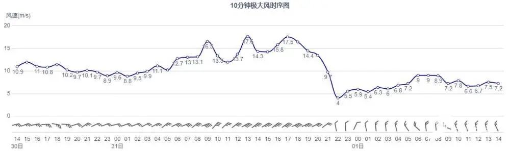
Qingdao Nanda Island, July 30th to August 1st, gusts (great wind) change
At present, the impact of "Sanda" on the wind and rain on the offshore of Shandong has basically ended. In addition, the center of Typhoon No. 6 this year's Typhoon "Cui Si" (tropical storm) is at 14:00 on the 1st on the 1st on the 1st of the north of the East China Sea, about 380 kilometers south of the Yellow Hainan Road, North Korea. Westward movement, the intensity gradually weakened, and it has no impact on our province.
From August 2nd, Shandong will usher in the continuous "sauna sky"

From August 2nd, the northwest Pacific subtropical high -pressure (referred to as the auxiliary high) will strengthen the west extension and control Shandong. On the 2nd to 6th, Shandong will usher in the high temperature of high temperature and rain. This time, the temperature is high, the air humidity is high, the physical temperature is high, and the duration is long. It is necessary to prevent the adverse effects of continuous high temperature.
Xiaobian remind everyone
Sanfu Tian, pay attention
Try to reduce long outdoor activities
Do a good job of preventing heat and cooling, drink more water
Protect your physical health
The "Rizhao Daily Video" is new!
- END -
Sichuan: Chen Kaijian Research on Sichuan Fiber Inspection Bureau Work

On June 14, Chen Kai, director of the Sichuan Provincial Market Supervision Bureau...
"Northeast Agricultural University -Dabei Nong Group Research Institute" was established
On the morning of July 18th, the Citizenship Contracts and Daeipon Public Welfare Fund donation ceremony was held in the school's concert hall. Focusing on the construction of the Northeast Agricultu...