The heavy rainfall is coming, and there will be 8 to 10 thunderstorms or hail!
Author:Hebei Radio and Television Sta Time:2022.08.06
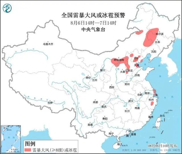
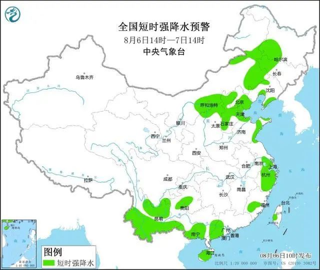
The Central Meteorological Observatory continued to issue a strong blue warning of the weather at 10:00 on August 6:
It is expected that from 14:00 on August 6 to 14:00, the eastern and southern parts of Inner Mongolia, south of Heilongjiang, western Jilin, northeast Shaanxi, northern Shanxi, western and northern parts of Hebei, eastern Beijing and northwest, Tianjin, Shandong, Shandong, Shandong, Shandong, Shandong, Shandong, Shandong, Shandong, Shandong The northern, Shanghai, central Zhejiang, and southeast coast of Guangxi will have 8-10 thunderstorms or hail weather; Inner Mongolia Hetao region and the central eastern, southern Heilongjiang, western Jilin, southern Liaoning, west, northeast Shaanxi , Northern Shanxi, Hebei, Beijing, Tianjin, Northern Shandong and East, southern Jiangsu, Shanghai, Zhejiang, central and southern Fujian, northwest of Guizhou and central, central, southern Yunnan, South Guangxi, western Guangdong, Hainan Island and other areas will be available In the short-term precipitation, the rainfall is 30-50 mm, and the local area can reach 80 mm or more.
It is expected that the main impact period of the strong convection is from the afternoon to the day of this afternoon to tomorrow.
Defense guide:
1. The government and relevant departments do a good job of preventing short rain, lightning protection, and anti -wind preparation in accordance with their duties. The meteorological department should prepare artificially hail prevention operations;
2. Outdoor pedestrians and staff reduce outdoor activities, pay attention to building buildings such as billboards and other buildings;
3. Drive poultry and livestock into a place with top pans, close the doors and windows to strengthen the sheds;
4. Active measures such as returning to Hong Kong to avoid or bypass the water in water operations and past ships. The construction site pays attention to covering building materials, and properly resettled outdoor items that are prone to heavy rain and hail;
5. Check the drainage system of cities, farmland, and fish ponds, and prepare for the preparation of drainage and prevention of disasters such as floods, landslides, and mudslides.

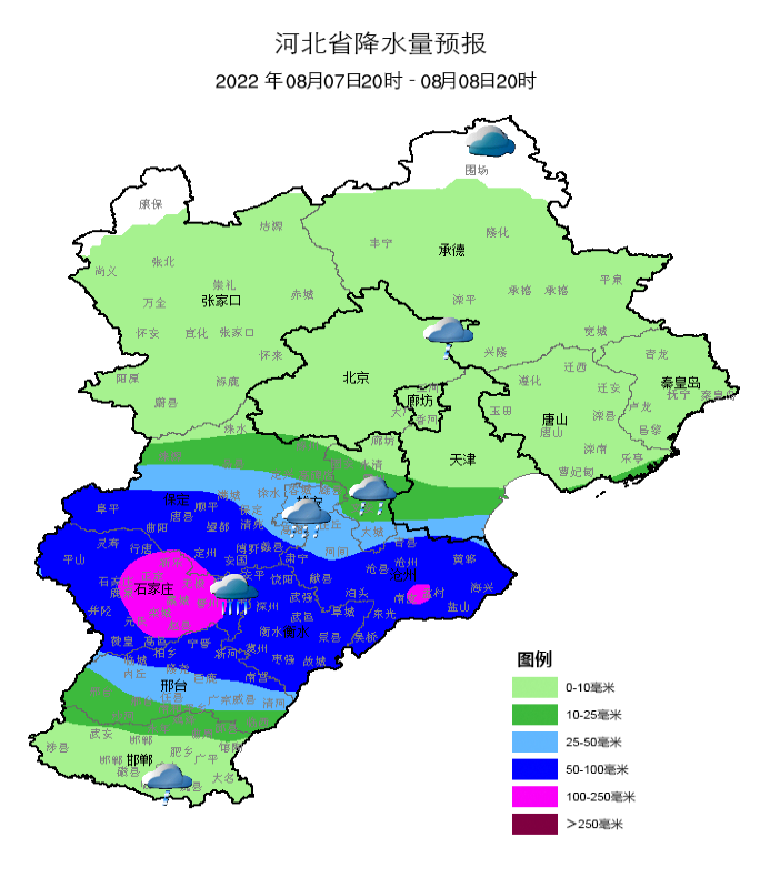
A new round of strong rainfall comes to some places heavy rainstorm
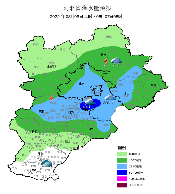
Affected by the subtropical high-pressure peripheral cut line, it is expected to rain in the province on 6-8, and the rainfall distribution is unevenly distributed. The volume is 40-80 mm, of which the cumulative rainfall in some areas of Baoding, Xiong'an New District, Southern Langfang, Shijiazhuang, Cangzhou, Hengshui, and Xing Taipei is 100-150 mm, and some locations can reach more than 180 mm.
The main rainfall appears: 7th to the night of the night.
From the 6th to 7th, it is mainly based on streaming and rainfall. The rainfall is strong. It is accompanied by lightning and short-term heavy precipitation (the maximum hourly rain is 50-80 mm/h), and the 8-10 short-term wind wind is strong.

Specific forecast
Hebei Meteorological Observatory released the weather forecast at 1122 on August 06:
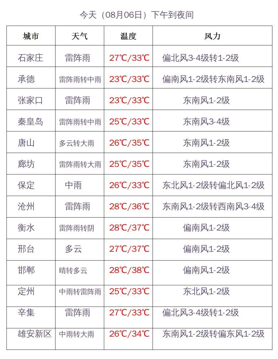
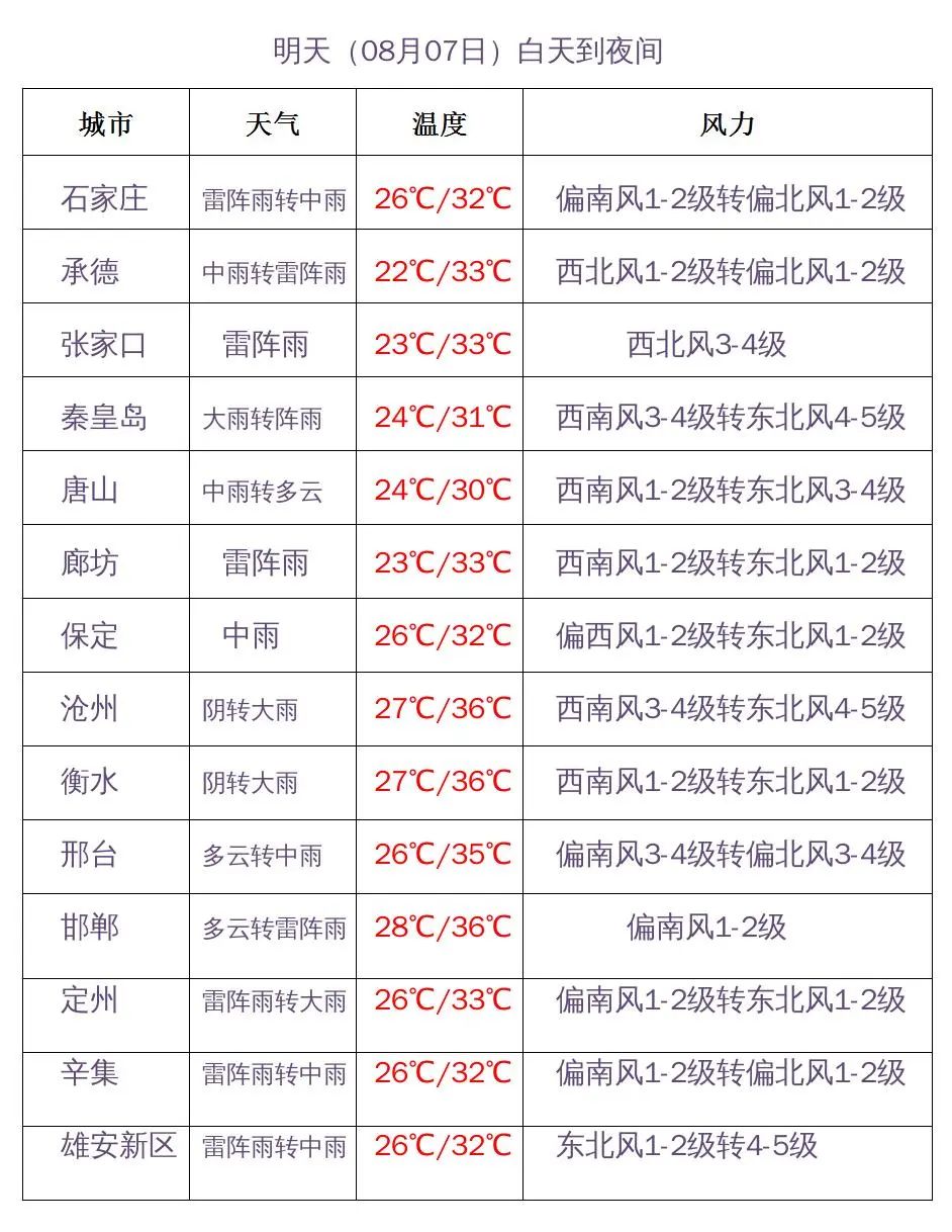
From this afternoon to the night, Xingtai and Handan Qing turned to cloudy, and there were thunder shower in other areas. Among them, southern Zhangjiakou, southern Chengde, Tangshan, Qinhuangdao, Baoding, Xiong'an New District, Langfang, Shijiazhuang, there were middle to heavy rain. At the time of thunderstorms, we have strong convective weather such as short -term precipitation and short -term wind.
Tomorrow day, there are thunderstorms in the east of Xingtai and eastern Handan, and there are thunderstorms in other areas. Among them, Tangshan, Qinhuangdao, Baoding, and Xiong'an New District have middle to heavy rain, and there are heavy rain in the local area.
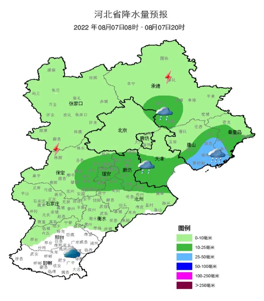
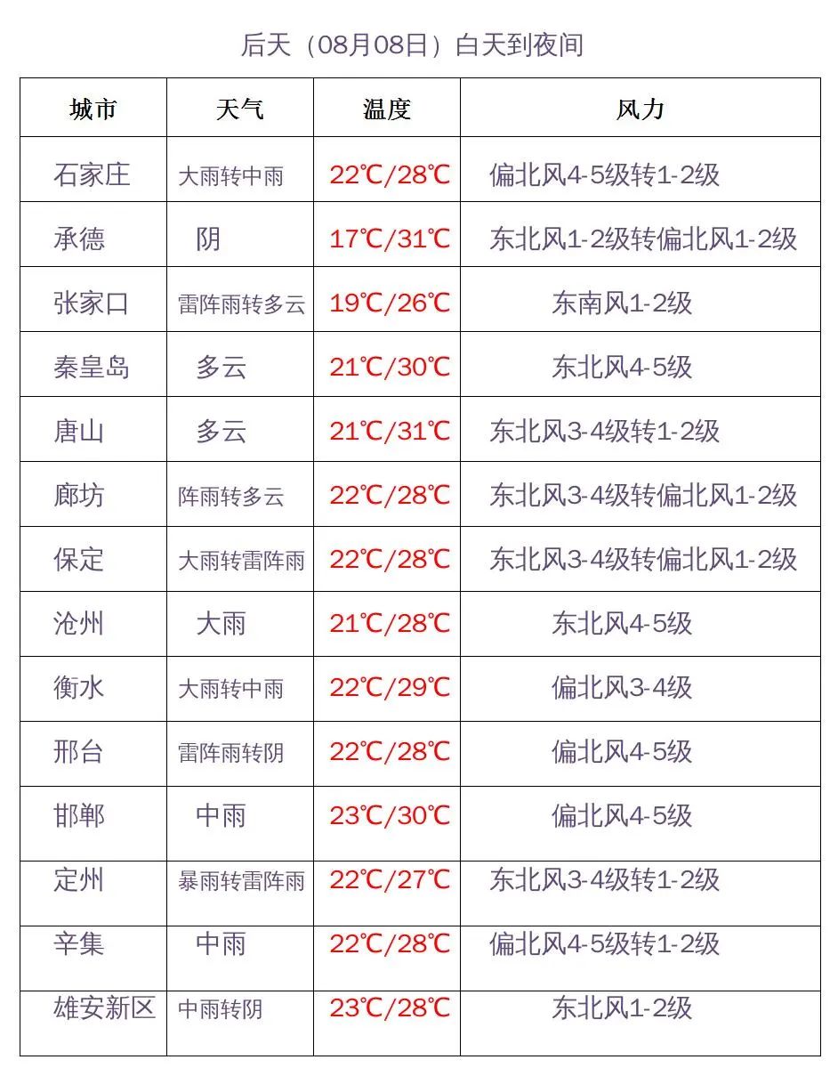
From tomorrow to 8th, the north of Zhangjiakou and northern Chengde, Yin, Baoding, Xiong'an New District, Langfang south, Shijiazhuang, Cangzhou, Hengshui, Xingtai have heavy rain to heavy rain, there are heavy rain in some locations, there are small rain in other areas, and it is accompanied by rain. There are strong convective weather such as lightning, short -term heavy precipitation, short -term wind.
From the night of the 8th to the 9th, there are thunder shower in the clouds in the northwestern region, and there are light rain in the central and southern regions. There are heavy rain in the local area, and there are clouds in other areas.
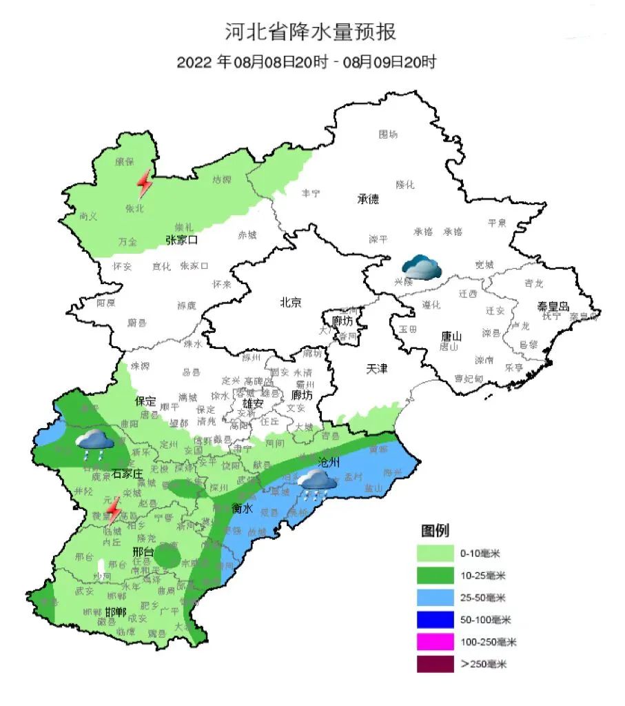
On the 8th, there are Northeast Winds 4 to 5 in the central and southern regions, and gusts 6 to 7; the waters and coastal areas along the coast of our province are 6 to 7 to 7 in the northeast wind, and the gust is 8.

Expert interpretation

6-8 precipitation forecast and interpretation
On the 6th, the deputy high -edge warm area precipitation, cutting into weakness, weaker wind farms, mainly decentralized convection water; 7 days on the east of high -altitude tanks, systemic precipitation caused by the combination of warm and cold air; Taihang Mountain low vortex formation and slowly moved eastward precipitation.
There are potential extreme extremes in precipitation:
The situation is stable: On the 7th, the cold air south pressure southward high southward, and the vice -outfilled enclosure was maintained in the central part of Hebei.
Water vapor conditions are good: atmospheric precipitation can exceed 80mm, 850HPA is higher than humidity (17-19g/kg), and water vapor is exceeded in the 2012 7.21 process;
Recently, high temperatures have continued to be high -temperature, and the accumulation of strong energy is conducive to the occurrence of storms and territory.
The uncertainty of precipitation exists:
Affected by the sub -high position, the rain belt is east -west; the deputy high north and the south dynamic changes are greater, and the rain areas and the intensity have certain uncertainties;
The position and duration of the low vortex system on the 8th are still uncertain;
The release of precipitation energy on the 6th and 7th, the energy conditions were deteriorated on the 8th, and the intensity of the convection was weakened.
(Expert support: Guiqin, chief of Hebei Meteorological Service Center)
Reason
This is a key precipitation in the main flood season of Hebei
Related departments and public
Be wary
Pay attention to forecast and early warning information in time
Do a good job of preventing
Also
Pay attention to avoid dangerous areas such as mountains and rivers
Play and event

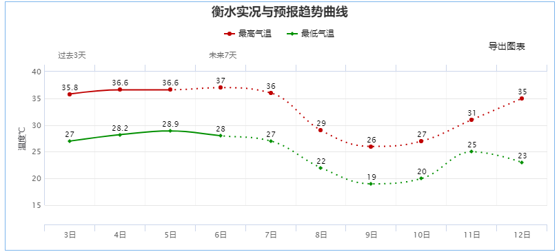
The rainfall is significantly cool down at the beginning of the week next week
today Tomorrow
Most of the high temperature in the south of the south can't go away
The weather is still very sultry

With the development of a new round of rainfall
Most of the highest temperatures at the beginning of next week (8th) will drop below 30 ° C
Effectively alleviated by the sweltering weather
(Hebei Meteorological Information Center)

Hebei Province's main cities forecast
•
- END -
Hebei Wuqiang: Carry out the safety of flying operations to ensure the safety of forests

Recently, the Natural Resources and Planning Bureau of Wuqiang County, Hengshui Ci...
Cultivate new kinetic energy in agriculture and rural development
At present, the focus of my country's agriculture and rural work has shifted to comprehensively promote rural revitalization. How to achieve the effective connection of poverty alleviation and the s...