Panda village border delineation story: 500 meters apart a fixed pile satellite remote sensing intelligent management
Author:Cover news Time:2022.08.09
Cover Journalist Tian Zhi Road
"Panda Village" is on fire! Last winter, a video of the villagers in Ya'an City, Sichuan Province occasionally encountered the Internet that encountered a panda that exploded the Internet, and the number of views in two hours reached millions of people. The construction of giant panda National Park has also attracted much attention.
Since the launch of the pilot pilot system in Sichuan in 2017, the Sichuan Surveying and Mapping Geographical Information Bureau has actively participated in the construction of the Grand Panda National Park and explored from the aspects of technical and methods. Essence
Determine the pile
Serve the Big Panda National Park boundary delineation
In January 2017, the "Grand Panda National Park System Pilot Plan" (hereinafter referred to as the "Plan") was officially issued. The "Plan" will organize more than 80 protective grounds in Sichuan, Shaanxi, and Gansu provinces, the main habitat of giant panda, and the panda area of the giant panda area. 27134 square kilometers. Among them, the area of Sichuan area of 20177 was in 20177, accounting for about 74%of the total area of the national park, mainly involving 7 cities in Mianyang, Guangyuan, Chengdu, Deyang, Aba, Ya'an and Meishan.
In October 2017, the sixth terrain surveying team of the Ministry of Natural Resources was commissioned by the Pilot Work of the Sichuan Grand Panda National Park System to promote the leadership group office to carry out the survey and mapping service of the survey of the Grand Panda National Park in Sichuan Province, and completed the survey of the survey. The required boundary paper map production, field survey survey, geographical information processing, boundary refinement and other tasks.
"In the past, people only knew that the mountain was classified as the giant panda National Park, but where the specific boundary is not clear." Wu Si, the person in charge of the production department of the sixth terrain measurement team of the Ministry of Natural Resources And daily supervision brings difficulties.
In December 2019, the sixth terrain surveying team of the Ministry of Natural Resources cooperated with the Sichuan Wildlife Resources Survey and Protection Station to complete the pile work of the first batch of pilot counties in Anzhou District and Meishan City, Mianyang District, Mianyang District, and Meishan City. Wu Si and his teammates are investigating here to determine the position of the boundary piles, and strictly carry out the burial and measurement of boundary piles in strict accordance with the standards. The boundary piles with a interval of about 500 meters after another have defined the precise boundary line for this giant panda national park.
On the basis of this, the sixth terrain surveying team of the Ministry of Natural Resources has established a database of the border pile, providing a data basis for the editing management, dynamic update, visual display, and statistical calculation of the giant panda national park boundary pile data.
Find out
Provide data support for the construction of Giant Panda National Park
In recent years, the number of giant panda population has gradually increased, and habitats suitable for giant panda life have continued to expand. According to the fourth national panda field survey data, there are 1,340 wild pandas within the scope of Grand Panda National Park, accounting for 71.89%of the entire wild giant panda population.
"The purpose of establishing Grand Panda National Park is to solve the problem of the panda population isolation and habitat connection." Wu Si introduced that the state breaks the restrictions of administrative divisions from space and will be The wild panda -intensive areas in 23 counties (cities, districts) are allocated into the national park, with the purpose of the purpose of achieving unified protection of cross -region.
The boundary of the Giant Panda National Park (Sichuan) is delineated, but the specific situation of natural resources, biological species, ecosystems, and humanistic activities in the park, as well as the current situation of protecting the integration and management of protective areas. The problem that needs to be solved urgently.
"After completing the determination pile, you need to find out the natural and humanistic family in the giant panda National Park." Wu Si said that the giant panda National Park is an important type of national natural protection land. The first function is to protect the great protection. The integrity and authenticity of the natural ecosystem of pandas and their habitats, comprehensively find out the family of natural and human geographical elements in the giant panda National Park, and timely grasp the natural elements and human activity status and change information of cultivated land, forest land, grassland, construction land and other natural elements It is of great significance to the construction of Grand Panda National Park.
In May of this year, the sixth terrain measurement team of the Ministry of Natural Resources used the technical methods and ideas of precipitated in previous monitoring work, combined with the national land change survey data in 2020, the national land use dynamic full coverage remote sensing monitoring data, and related special information for the national land use dynamic use dynamic dynamic dynamic coverage of remote sensing monitoring data, and related special information. The characteristics and protection of natural resources in this area, using spatial analysis, statistical analysis, geographical -related analysis and other methods to carry out natural resource development and utilization monitoring and natural resources protection to the giant panda National Park (Sichuan) with an area of more than 20,000 square kilometers. Repair monitor.

The monitoring work started from two aspects: the basic status of natural resources and changes in natural resources, and finally formed a natural resource remote sensing monitoring report with graphic panda National Park (Sichuan). 2. Collaborative effects on the protection of giant panda provides data support and guarantee.
R & D platform
Serving the construction of intelligent management of Grand Panda National Park
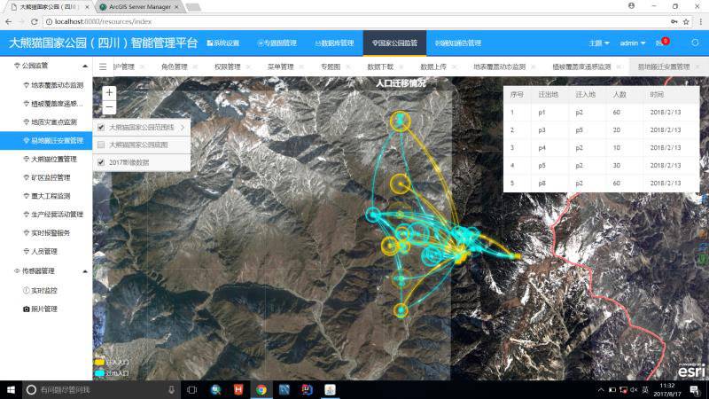
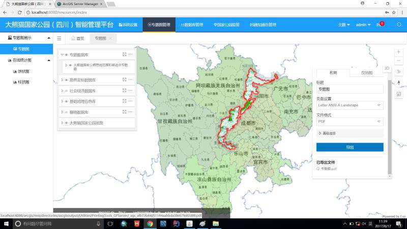
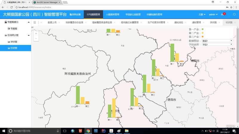
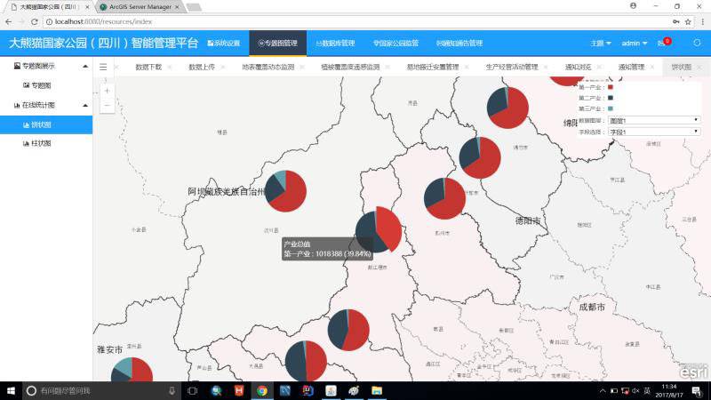
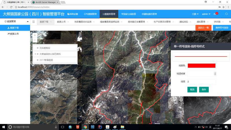
In order to achieve the efficient use of the results of the data of the pile, improve the intelligence, informatization and visual management level of the Big Panda National Park, and better serve the natural protection of the Grand Panda National Park. The Grand Panda National Park (Sichuan) intelligent management platform has also been developed.
At the Geographical State Monitoring Center of the Sixth Territories Measurement Team of the Ministry of Natural Resources, Wu Si introduced the smart management platform on the computer while opening the computer on the computer. The platform includes user management modules, special map display modules, database management modules As well as modules such as the national park supervision, the two -dimensional three -dimensional integration data visualization and intelligent management have provided information support for the intelligent management of Grand Panda National Park (Sichuan). "In April of this year, we joined forces with the construction of the ecological management platform of the Grand Panda National Park (Aba) Ecological Management Platform."
According to the construction needs of the Grand Panda National Park, the Sichuan Basic Geographic Information Center of the Ministry of Natural Resources adopts technical means such as satellite remote sensing, Beidou navigation, space -time big data, geographical information system, and three -dimensional visualization. It is also delivered to the Aba Management Branch of the Grand Panda National Park National Park Province, providing data and informatization support for the definition and definition, daily patrol, ecological monitoring, environmental protection law enforcement, etc.
It is understood that in the future, the Sichuan Surveying and Mapping Geographical Information Bureau will also invest more to continue to serve the construction of Grand Panda National Park. With the continuous investment of more strengths, the giant panda National Park will be better and better, and the chances of people in the park will encounter giant pandas will become higher and higher.
- END -
The rhythm of losing!Liaoning Basketball behind the first quarter, how much patience does the two people show spicy eyes Yang Ming?

On July 18, the CBA Summer League continued, and the opponent of the Liaoning team...
Studies and regulations are in order to promote the development of trees

The style is hard, and the unit construction can be excellent; the discipline is s...