Typhoon "Mulan" is big!The path is weird!Or effectively alleviate high temperature in South China | Expert interpretation
Author:China Meteorological Administr Time:2022.08.09

Typhoon Magnolia, No. 7 this year, has been generated on August 9th and will land on the coast of the area from Wenchang, Hainan to the Yangjiang area of Guangdong from noon to night from August 10th to night. The level is a tropical storm. At 16:00 on August 9th, the Chinese Meteorological Administration launched a typhoon level four emergency response. The Central Meteorological Observatory continued to issue a typhoon blue warning.
How will the typhoon "Mulan" develop? Does the future affect my country's storms? How to prevent it? Typhoon Typhoon and Marine Meteorological Forecast Center Gao Tiezhu accepted a reporter interview and interpreted related topics.
Question: What path moves by typhoon "Mulan"? How is the intensity?
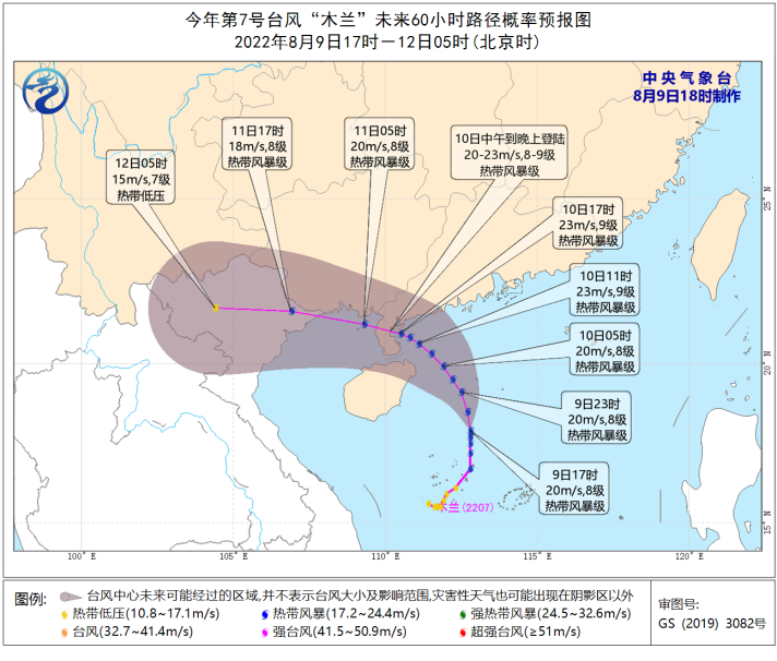
Expert: At 19:00 on August 9, "Mulan" was about 350 kilometers southeast of Xuwen County, Zhanjiang City, Guangdong Province, with a maximum wind of 8 (20 meters/second), and the lowest air pressure in the center was 995 hundred Pache. It is expected that from August 9th to 11th, "Mulan" will move north at a speed of 20 kilometers per hour. After moving to the sea near the western part of Guangdong, it will move to the west direction and via the northeast of Hainan Island and Leizhou The peninsula entered Beibu Gulf and finally landed in northern Vietnam. In the process, the speed of movement gradually accelerated, the intensity gradually increased, but it remained at the tropical storm level.
Question: What areas of the typhoon "Mulan" influence? What kind of wind and rain impact?
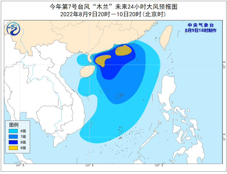
Experts: In the next few days, strong wind and rain will appear in Guangdong, Guangxi, and Hainan. From 20:00 on August 9th to 20:00, the South China Sea, the Qiongzhou Strait, the eastern part of the Beibu Gulf and the coast of Guangdong, the eastern coast of Hainan Island, the waters near the Nansha Islands, the waters near the Xisha Islands, Grade 6 to 7 winds, the waters in the northern part of the South China Sea and the coastal winds in the central and western Guangdong are 8 to 9, and the gusts are 10 to 11th. There are heavy rain or rainstorms. Among them, there are heavy rains in parts of the southwestern part of Guangdong and northwestern Hainan Island.

Q: What are the characteristics of typhoon "Mulan"?
Expert: "Mulan" is characterized by a large and strange path, so it is necessary to pay attention to the impact and development trend of wind and rain. Because "Magnolia" is not completely separated from the low pressure of the monsoon, it maintains its huge volume and has a large influence; and the "Mulan" structure is loose. Storm impact. In addition, the "Mulan" path is different. In most cases, the typhoon that affects our country first follows the "Westward path" and then turns to the "Northeast path". However, the "position" of "Mulan" is the "inverted parabolic line" path that turns north to north and then to the northwest.
Question: Will the typhoon "Mulan" alleviate the high temperature weather in the south?
Experts: At present, high temperature weather in the south of my country continues, and "Mulan" will send coolness to some areas. Rainstorming and winds in southern Guangdong, south of Guangxi, Hainan and other places will effectively alleviate the impact of high temperature weather. However, due to the current subtropical high -pressure east -west stretching and comprehensive form, the overall power is strong, and the road of typhoon "north" is stopped, "Mulan" cannot continue to "go north". Therefore, the high temperature relief effect of "Mulan" in Central China, Jiangnan and other places is very limited.
Q: How to improve the accuracy of forecasting?
Experts: In order to better monitor "Magnolia", the China Meteorological Administration's Earth System Numerous Forecast Center, National Meteorological Center, National Satellite Meteorological Center and other units jointly conduct "South China Sea Typhoon Empty World Cooperation and Real -time Assimilation Forecast Test". The observation aircraft of the Hong Kong Observatory carried out aircraft observations, and monitored data such as typhoon wind speed in vertical directions. The National Satellite Meteorological Center uses Fengyun No. 4 satellite for collaborative observations. The encryption observation materials of aircraft and satellites undoubtedly provide more first -hand information for precise forecasting.
Produced by China Meteorological Administration Xuanke Center (China Meteorological News Agency)
Author: Xu Nenyu
Video: Xing Jianmin
Edit: Yang Shenglan Bao Ning
Review: Duan Haoshu

- END -
Bai Shiying: Pay hard to protect women and children happiness

She is Xilingule LeagueThe spokesperson who protects the legitimate rights and int...
Small ship models witnessed the development of Xiamen Shipbuilding Industry to the world

In the captain's cab, there is usually a ship model. This is presented by the ship...