South China Jiangnan's heavy precipitation continues!Be wary of the risk of flood in the Pearl River Basin!| Expert interpretation
Author:China Meteorological Administr Time:2022.06.17

Since June
Southern heavy rainfall keeps
Floating disasters occur in many places in South China, Jiangnan and other places
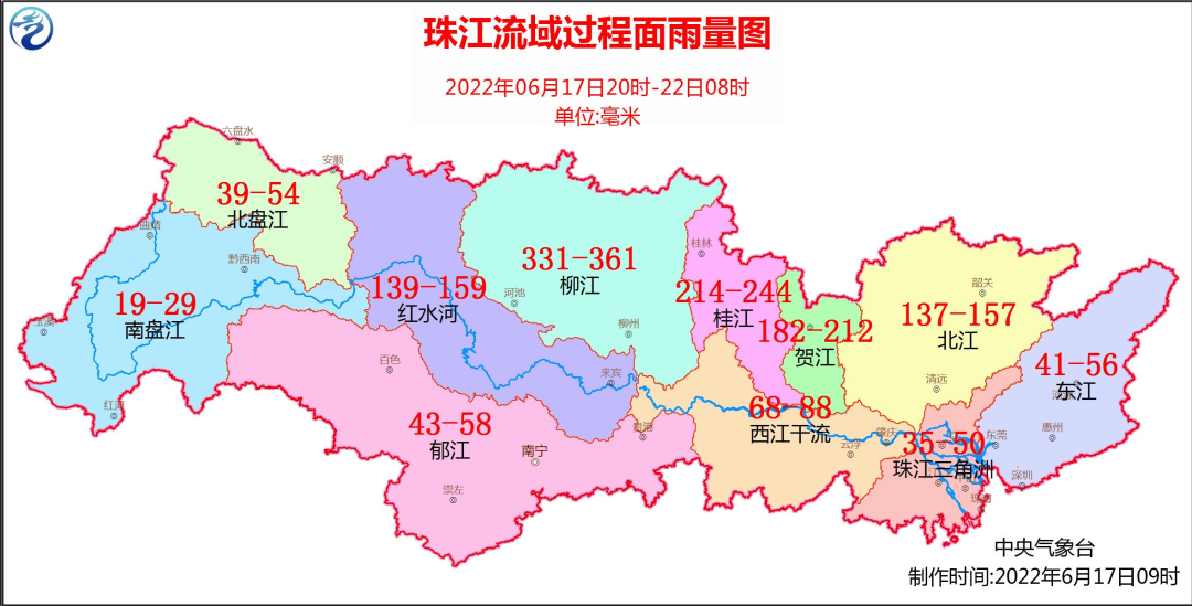
117 rivers in the Pearl River Basin occurred in a super police flood
Number of floods occurred in Xijiang, Beijiang, and Hanjiang
Central Meteorological Observatory estimates
17th to 21st
There is still a large -scale heavy precipitation process in Jiangnan and other places in South China
And upgraded the heavy rain yellow warning at 10:00 on the 17th
China Meteorological Administration launched a third -level emergency response

What are the characteristics of strong precipitation in the south?
What is the precipitation in the Pearl River Basin?
Central Meteorological Observatory Basin Hydrological Meteorological Forecast Center
Senior engineer Xu Hui interpreted this
Xu Hui, senior engineer of the Central Meteorological Observatory Basin Hydrological Meteorological Forecast Center, interprets the southern heavy rainfall process
The scope of the long precipitation duration is strong and the rain is strong. The rain is strong
In the next few days, heavy rainfall in the south will still be "online". From June 17th to 21st, South China and Jiangnan will still have heavy rainfall. As the east section of the rain continues to be lifted north, heavy rainfall will also occur in the middle and lower reaches of the Yangtze River. Xu Hui introduced that this round of strong precipitation process has the characteristics of long duration, extensive influence, and powerful rain. The strongest precipitation period will appear from 18th to 20th. It can also reach more than 80 mm in the hour.
The Central Meteorological Observatory was upgraded at 10 o'clock on the 17th and issued a yellow warning: It is expected that from 14:00 on June 17th to 14:00 on the 18th, southeast of Tibet, northwestern Yunnan, southern Guizhou, southern Hunan, eastern and southern Jiangxi, southern Zhejiang, central Guangxi central There are large rainstorms in parts of the north, Guangdong, western and northern parts of Fujian. Among them, there are heavy rains (100 to 150 mm) in northwestern Guangxi, northern Guangdong, northwestern Fujian, and southern Zhejiang. The above area is accompanied by short -term heavy precipitation (the maximum hourly rainfall is 20 to 50 mm, and the local area can exceed 60 mm), and there are strong convective weather such as thunderstorms.
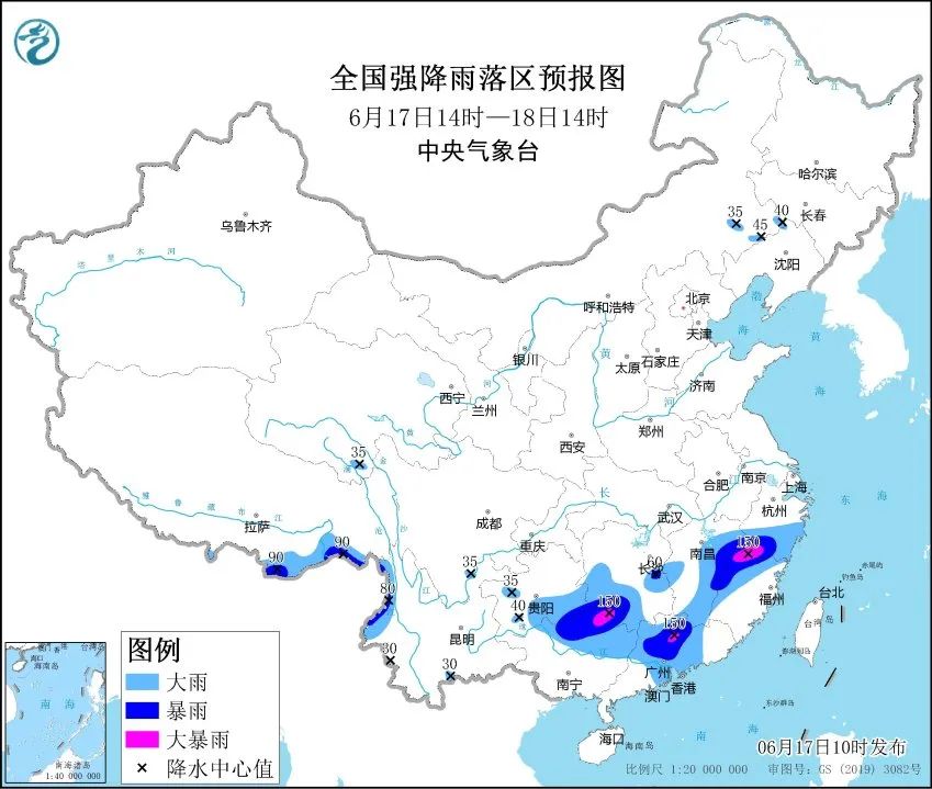
In addition, this round of heavy rain areas overlapping high in the early stage, especially in northern Guangdong and northwestern Guangxi, the risk of stacks in precipitation has increased significantly. We must be alert to the adverse effects of strong precipitation.
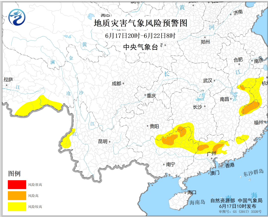
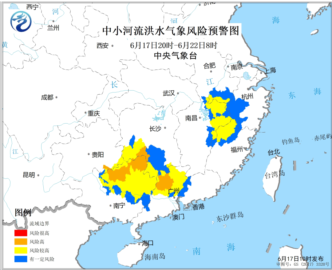
The Meteorological Risk of the Pearl River Basin continuously occurred in the watershed floods high
Affected by strong precipitation, in the past five days, a strong precipitation of more than 100 mm has appeared in the north of the Pearl River Basin. Northeast and northern Guangdong and northern Guangdong have appeared in a heavy rain of more than 250 mm.
In the next few days, the precipitation weather in the Pearl River Basin will continue. In the early stage of precipitation, the water content of soil in most areas has a high water content and high water levels in the river reservoir. It is also necessary to strengthen secondary disasters such as rumors, geological disasters, floods of small and medium -sized rivers, and urban waterlogging.
Xu Hui reminded that at present, the water level in the river reservoir in Guangdong, Guangxi, Fujian and other places is high. In the next three days, the above -mentioned areas will continue to appear in heavy rainfall. The public in related areas need to pay close attention to the changes in rain and flood conditions. Reservoir dangerous situation.
Weekend rainstorm continues to decrease without going out
Xu Hui reminded that the heavy rain in the south continued. It coincides with the weekend, please pay attention to the weather forecast warning issued by the meteorological department in time. Try not to go out during the rainstorm. When you must go out, you should bypass the serious location of the water. In the concentrated road section of the wire, we must be alert to falling into drainage wells, pit, etc.; Do not ride bicycles and electric vehicles during rainstorms to prevent wrestling; heavy rain coming, driver should try to be as deep as the road or overpass under the bridge of the overpass, you should try to try to try to try to try to try to deposit as much as possible. Bypassing, if you turn off in a low -lying place, you should leave the vehicle immediately to the high place to wait for the rescue.
What should I do if I encounter heavy rain?
Poke videos to understand
"Data-version =" 0 "data-vwidth =" 852 "data-vHeight =" 480 "transcoding =" 1 "style =" width: 400px; "> Produced by China Meteorological Administration Xuanke Center (China Meteorological News)
Author: Zhang Linhao
Expert Consultant: Xu Hui, senior engineer of the Central Meteorological Station Basin Hydrological Meteorological Forecast Center
Edit: Brush
Review: Wang Chen Zhang Yong

- END -
Longyan Yongding District Meteorological Observatory issued heavy rain blue warnings [Class IV/Gener
Longyan Yongding District Meteorological Station, June 09, 2022, at 00:42 at 009: 42, a change of heavy rain blue warning signal: In the past 12 hours, Hulei Town, Jinsha Town, Fuxi Town, Xixi Townshi
The 2022 Bay Gao Tour Talk was successfully held in Shanwei

In order to implement the Outline of the Construction of Intellectual Property Pow...