Typhoon No. 9 this year will be generated today and will land on the 25th on the 25th
Author:Guangzhou Daily Time:2022.08.22
The center of the tropical low pressure of the east side of the Philippines is the northwestern Pacific Ocean, which is about 475 kilometers north of the east of Manila, Philippines at 5 am today (22nd) at 5 am.There are level 7 (15 meters/s), and the lowest air pressure in the center is 1,000 hundred Pache.
It is expected that the low-pressure center will move west at a speed of 7-10 kilometers per hour. After the evening of the 22nd, it will move to the northwest to move, and will be strengthened to Typhoon No. 9 this year on the 22nd.Later, it will be moved into the northeast of the South China Sea in the early morning of the 24th, and gradually approach the coast of Guangdong. The intensity will continue to increase.In the above coastal landing (23-28 meters/s, 9-10, tropical storm or strong tropical storm).After landing, the intensity gradually weakened.
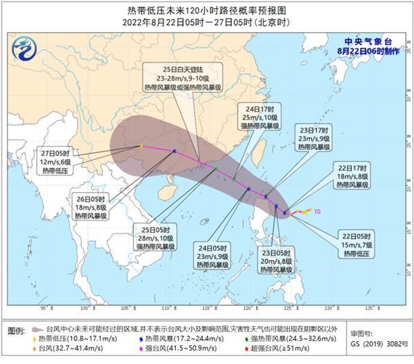
Affected by it, from the 23rd to 25th, there will be obvious wind and rainy weather in the southern sea area and the coast of South China.
Source: People's Daily Client Guangzhou Daily · Xinhuacheng Editor: Long Chengliu
- END -
Quwo County Meteorological Bureau to lift the thunderstorm and blue warning [Class IV/General]
The Quwo County Meteorological Observatory was lifted at 23:02 on June 9, 2022 to lift the thunderstorm and blue warning signal, and the area: all towns and villages.
Taoyuan Nine Middle School raised a donated money for the sick student Tang Qingxia for 170,000 yuan

Huasheng Online (Correspondent Liu Xingwen) On June 24, Huang Jihua, Secretary of ...