Quick expansion!Typhoon "saddle" will log in tomorrow!Xiamen will usher in ...
Author:Straits Herald Time:2022.08.24
focus on! Just released!
The latest news is here!
Xiamen people pay attention!
Grade 12
Typhoon "saddle" is expected to log in tomorrow
Xiamen issued an early warning, and next ...
According to the Central Meteorological Observatory 6 am this morning
Typhoon yellow warning:
At 8 am this morning, the "saddle" (strong tropical storm) is located on the sea about 630 kilometers south of Yangjiang, Guangdong, with the largest 10 levels of wind 10 (28 meters/s) near the center. The intensity of "saddle" will continue to increase, and from the morning of the 25th to the afternoon from the afternoon of Guangdong to Zhanjiang, the coastal landing (25 ~ 33 meters/s, 10 ~ 12, strong tropical storm or typhoon) The intensity gradually weakened.
Affected by the "saddle", it is expected that there will be heavy rain or heavy rain along the coast of southern Guangdong, northeast of Hainan, and south of Guangxi, and heavy rain in the area. The wind power in the nearby waters or regions passed by the "saddle" can reach level 9-12, and the gusts are 13-14.
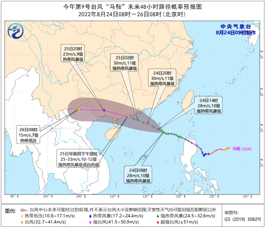
Affected by typhoons, today's southwestern Taiwan Island, along the coast of Guangdong, and the eastern coast of Hainan Island will have 6-8 gales.
This
Xiamen Meteorological Observatory continues to release today
The city's "Typhoon Warning Grade IV"!
Xiamen general welcoming
Dafeng+rainfall+local strong convection!
Strong wind
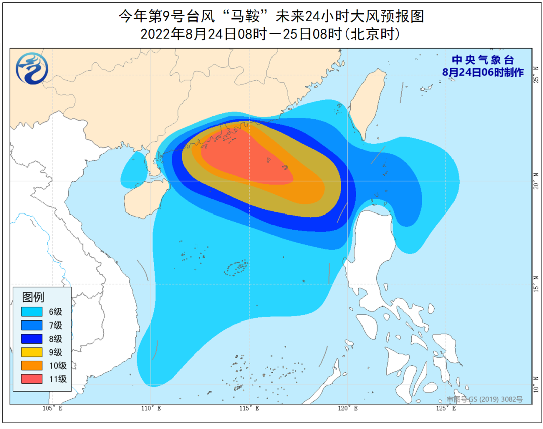
Affected by the "saddle" of the typhoon, the city and coastal winds have been strengthened from the morning of the 24th to 25th. Level 6 and gusts 7 to 8; Chongwu to Dongshan's largest coast can reach 6-7 and gusts 8-9 levels; the largest 7-8 levels in the southern Taiwan Strait, and gust of gust 9-10. The wind gradually weakened from the afternoon of the 25th.

Rainfall, strong convection
Affected by it, Xiamen and coastal winds in the morning of the 24th to 25th have increased. There are showers or thunderstorms, and there are heavy rain in some areas. During the precipitation, the situation is accompanied by a short -term heavy precipitation, thunderstorm and so on.
It is recommended that vessels that affect the sea area in the sea should return to Hong Kong to avoid wind or avoid typhoons in a timely manner. Coastal scenic spots and island -related tourism must strengthen safety management. At the same time, please pay attention to the collapse, landslide and other geological disasters such as collapse, landslides and urban and rural waterlogging caused by the short -term intense precipitation.
Typhoon approaching!
Xiamen continues to be high -temperature warning!
The local area can exceed 39 ° C!
Under the control of the typhoon "saddle" peripheral
Xiamen has eaten crazy these two days in the past two days
Air -conditioning unit mode is close to the city
High temperature continues! High temperature continues!
This morning
Xiamen issued again:
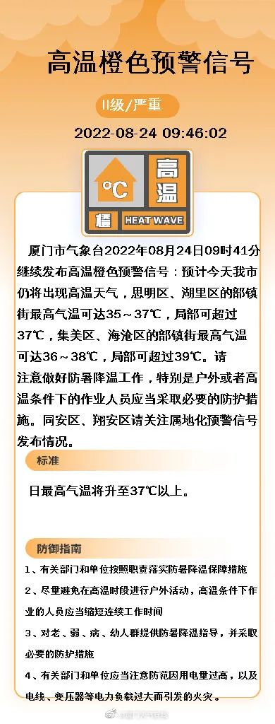
High -temperature orange warning signal!
Xiamen Meteorological Observatory continued to release high -temperature orange warning signals at 09:41 on August 24: It is expected that high -temperature weather will still appear today in our city. The highest temperatures in some town streets in Siming District and Huli District can reach 35-37 ° C. More than 37 ° C, the highest temperature in some town streets in Jimei District and Haicang District can reach 36-38 ° C, and the local area can exceed 39 ° C. Please pay attention to prevent! Intersection Intersection
Log in with typhoon
When will Xiamen cool down?
The answer is here!
According to the latest release of Xiamen Meteorological ——
Typhoon and cold air come to "support"
Xiamen will usher in a small cooling
Forecast
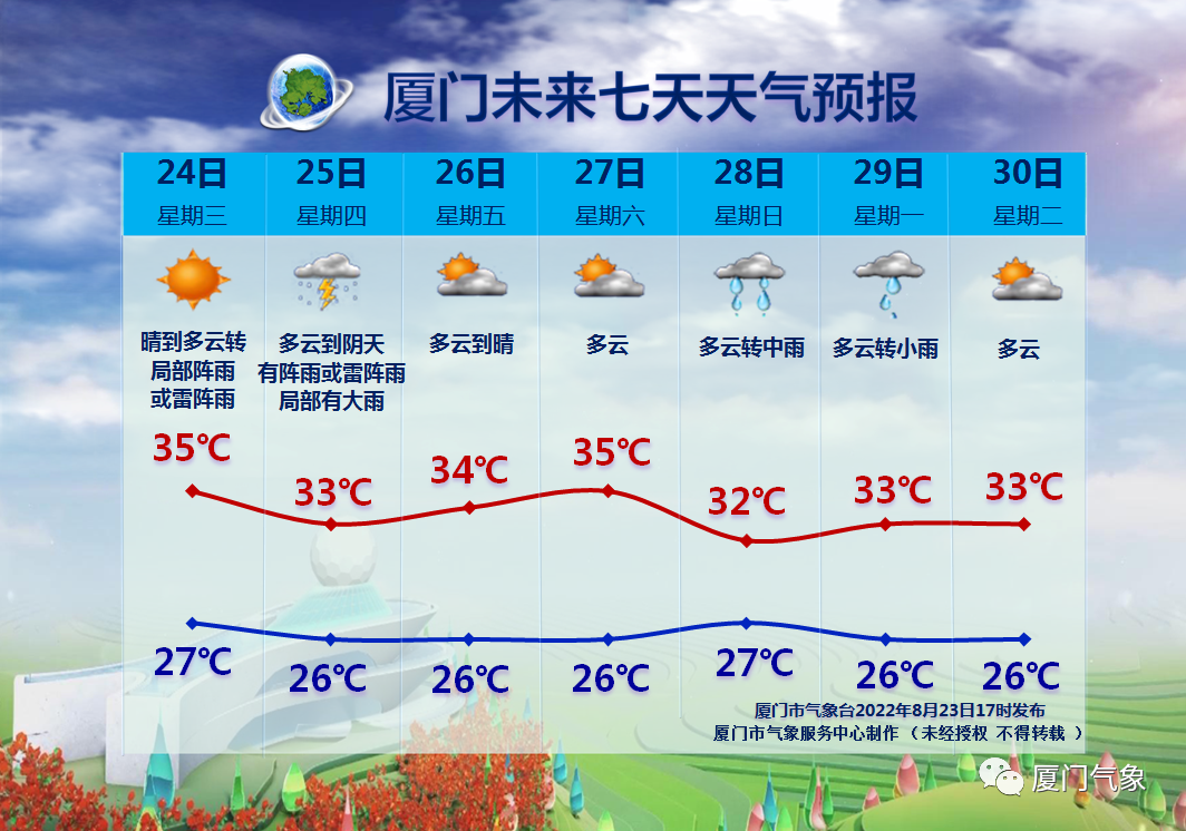
Tomorrow (25th)
Under the influence of the circulation of the typhoon
There will be a little precipitation and cooling
By No. 26
Subjective high -voltage back to "home" again
The temperature will rise again
High temperature weather on the 27th is "dipped in" again
However, the good news is
Start this Sunday
Self -cold air penetration in the north
We look forward to the long -awaited cooling and precipitation
Will appear one after another, everyone will wait patiently!
Comprehensive @Meteorological Observatory, @Xiamen Weather Online, Xiamen Meteorological
Editor Chen Siqin
Straits Herald WeChat (ID HXDBWX) Integrated Edit


Just report! 1 new case in Fujian! Siming, Lake, Jimei, Haicang, Tong'an, Xiang'an latest notice!

just! Xiamen issued a notice! Primary and secondary school kindergartens have been set!

Suddenly announced! Completely prohibited! Intersection

just! Xiamen Lianli Early Warning!
Herald WeChat matrix


point

and

Hope typhoon and cold air to cool down!
- END -
Suddenly stopped residents who were worried about emergency repairs to relieve the people -Beipingzhuang Street quickly responded to the score of scores to restore water supply

Bei Taipingzhuang Street/Photo ConstructionHello, my family cooks halfway, and sud...
The first batch of 30 -day diary was exposed after 00 -after work

Sayings:The first batch of post -00s graduated, and I have been working in the job...