The provinces of the Yangtze River are so hot that doubt life
Author:Institute of Physics of the Ch Time:2022.08.24
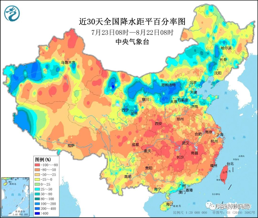
Since the flood in the flood, from the "drying" of the Jialing River in Chongqing, to the river channel of the Yangtze River on the Yangtze River in Wuhan, to the "thin" Lightning Lake, and then to the naked exposure of "lying" in Yanshan, Poyang Hunan, Beach coating ... Various news during the flood season frequently see various media.
It should have been caught in the flood season in the flood season, but most parts of the Yangtze River Basin have a rare phenomenon in the flood season. Why is there such a rare phenomenon?
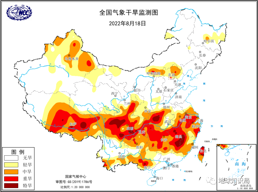
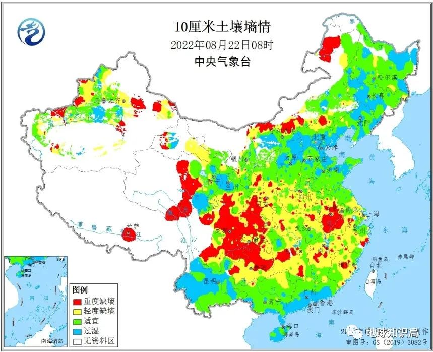
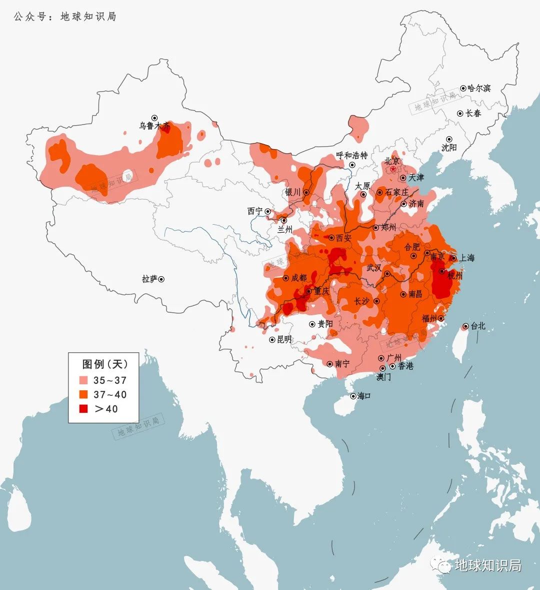
The Yangtze River Basin has become a special drought disaster area
(Figure: Central Meteorological Observatory)
Today's article, let's find the answer from the conditions formed by the Yangtze River flood season.
Where does the water from the Yangtze River come?
Where does the water from the river come from? Simply put, it is mainly the spring water in the origin of the river, the ice and snow melting water and the precipitation of the high mountains, and the Yangtze River is no exception.
The Yangtze River is the richest river in my country, with a total water resources of 961.6 billion cubic meters, accounting for about 36%of the country's total runoffs, 20 times that of the Yellow River. Even if you look at the world, the water volume of the Yangtze River is second only to the Amazon and Congo River in the equatorial tropical rain forest, ranking third.
Dry flow+major tributaries are the pillars of my country's water can be developed
From the perspective of the type of water volume of the Yangtze River, the main water source of the majestic flow of the Yangtze River is obviously not its birthplace -the spring of the Ladan Winter snow peaks in the Qinghai -Tibet Plateau, nor is it the ice and snow on the 3000 -meter plateau. The amount of water in the Yangtze River is from precipitation from the river in the basin.
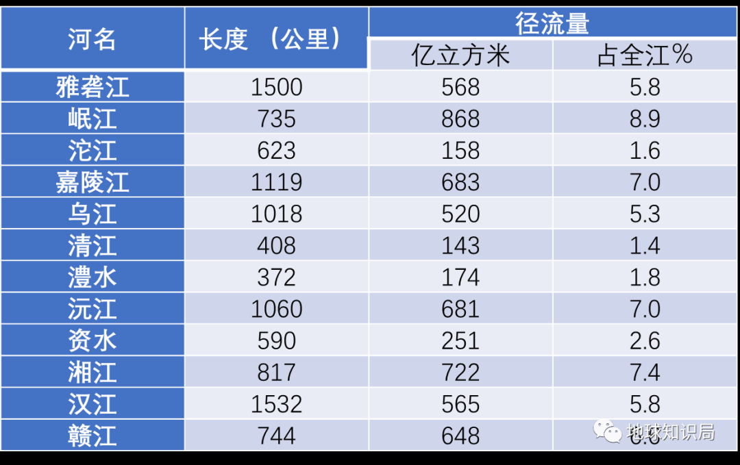
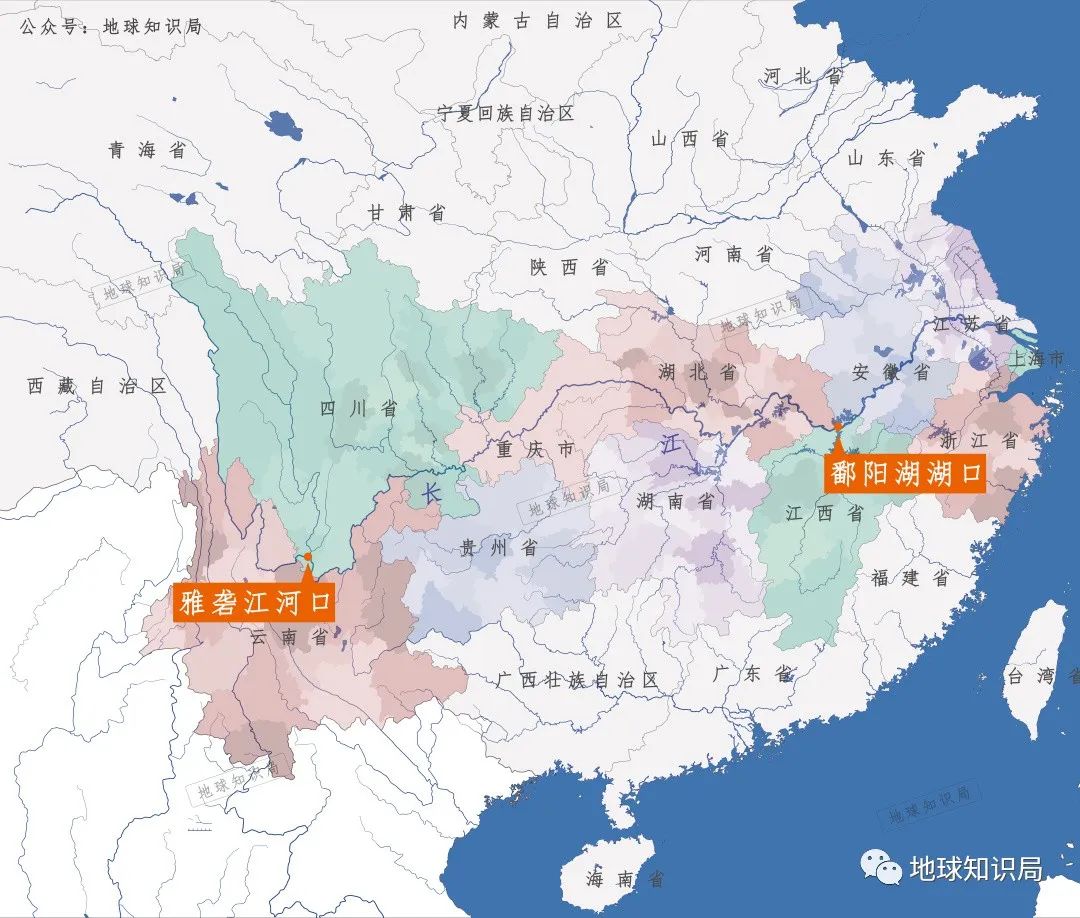
From the perspective of the space distribution of the water volume of the Yangtze River, 80%of the water entry water in the Yangtze River comes from the Estuary of the Yazhen River River estuary, which only accounts for only 28%of the Yangtze River process to Poyang Lake. Although this process is less than one -third of the Yangtze River, it brings together a small tributary to bring rich water to the Yangtze River.
The tributary of the Yangtze River and its tributaries nourished many provinces in the south of my country
Among them, although the length and area area of the Minjiang River are not very large, the amount of water is second to none in each tributary. The reason is that most of the Minjiang River Basin (including its tributary Dadu River) is located in the mountains of western Sichuan.
Dujiangyan project in Minjiang River
Created the country of Tianfu, Chengdu, Sichuan
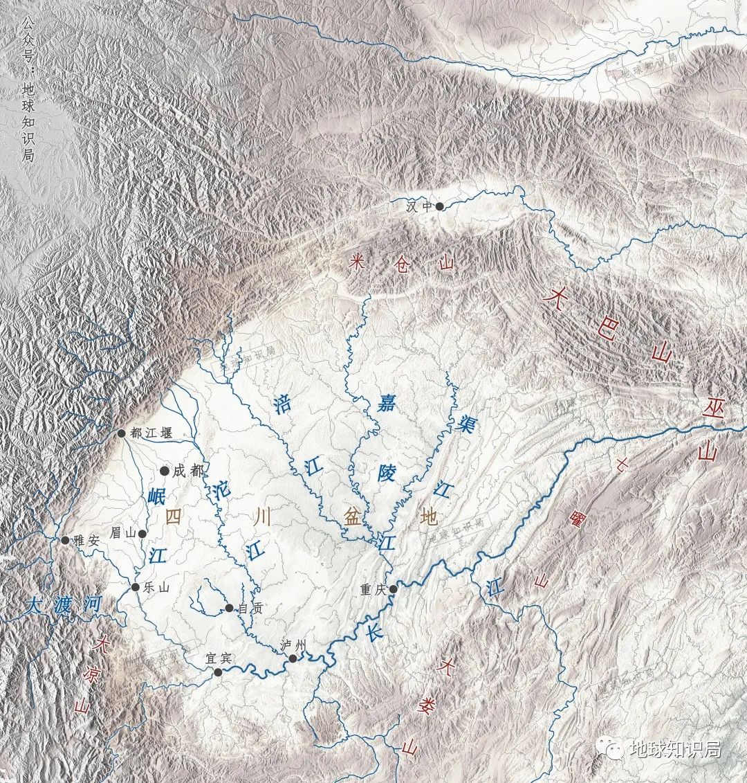
Most of the mountains here are distributed in the southwest-northeast, which is exactly the windy slope of the Southeast monsoon, which has formed several rain centers. The ancients also used the descriptions of "Bashan Night Rain" and "Xishu Lottery" to reflect the rich precipitation here.
After the warm and humid air flows into the Sichuan Basin, it is easy to form a cloud
The clouds cover the sun during the day, so that the low temperature at low altitude is not high
The temperature difference between the upper and lower clouds is small, which is not conducive to the flow activity
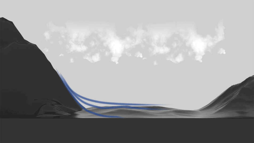
Quick cooling above the clouds at night
The cloud layer absorbs the long wave radiation of the ground, making the low -altitude temperature below the high temperature higher
It is easy to trigger the convection in the cold and warm, and night rain appears
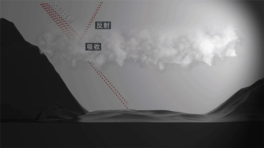
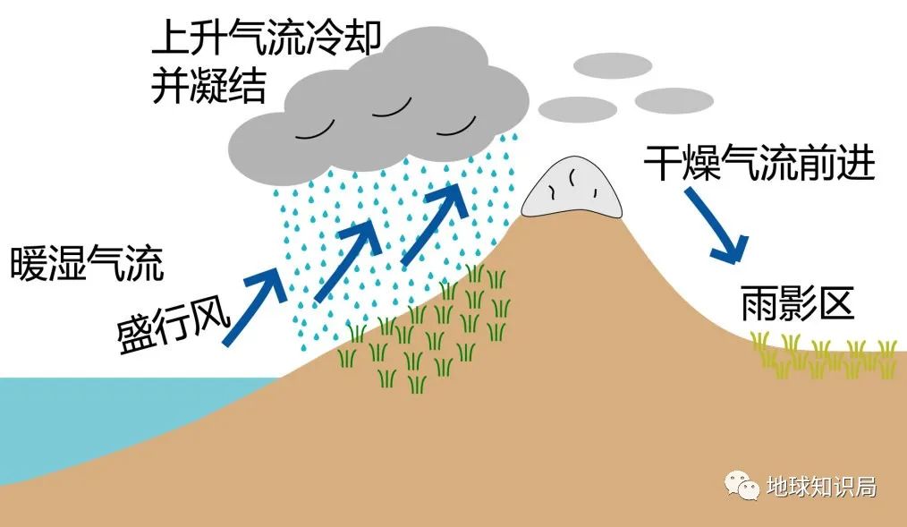
Recently, Chongqing media often reported that the nearly dry Jialing River is the third largest tributary of the Yangtze River. Different from the Minjiang River, the Jialing River Basin is located in the northwest of the Daba Mountain and the Wushan Mountains. It happens to be the backwind slope of the southeast monsoon. It belongs to the "rain shadow" area. The average precipitation is usually less than 1000 mm.
The warm and humid air is raised due to the terrain and the terrain
Decreasing air pressure makes the warm and humid air cooling and condensed forming precipitation, becoming a "rain slope"
Then the air reached the back of the air, and the water content in the air had been reduced in large quantities
Make the backwind surface forming rain shadow, also known as "Ganpo" (Figure: wiki)
However, the areas flowing through the Jialing River are distributed with a large area of red sand rocks, which is not conducive to the infiltration of water. Therefore, most of the runoffs flow into the downstream. The two major tributaries of the Jialing River and the Minjiang River were remitted into the Jialing River at the same time in Hechuan, Chongqing.
In Hechuan District, Chongqing, the Minjiang River enters the Jialing River from the west
Not far east, Qujiang also entered the Jialing River from the east
(Figure: Tuwa Creative)
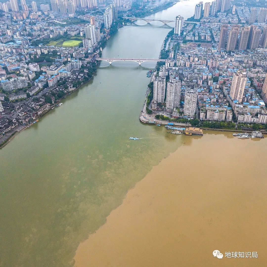
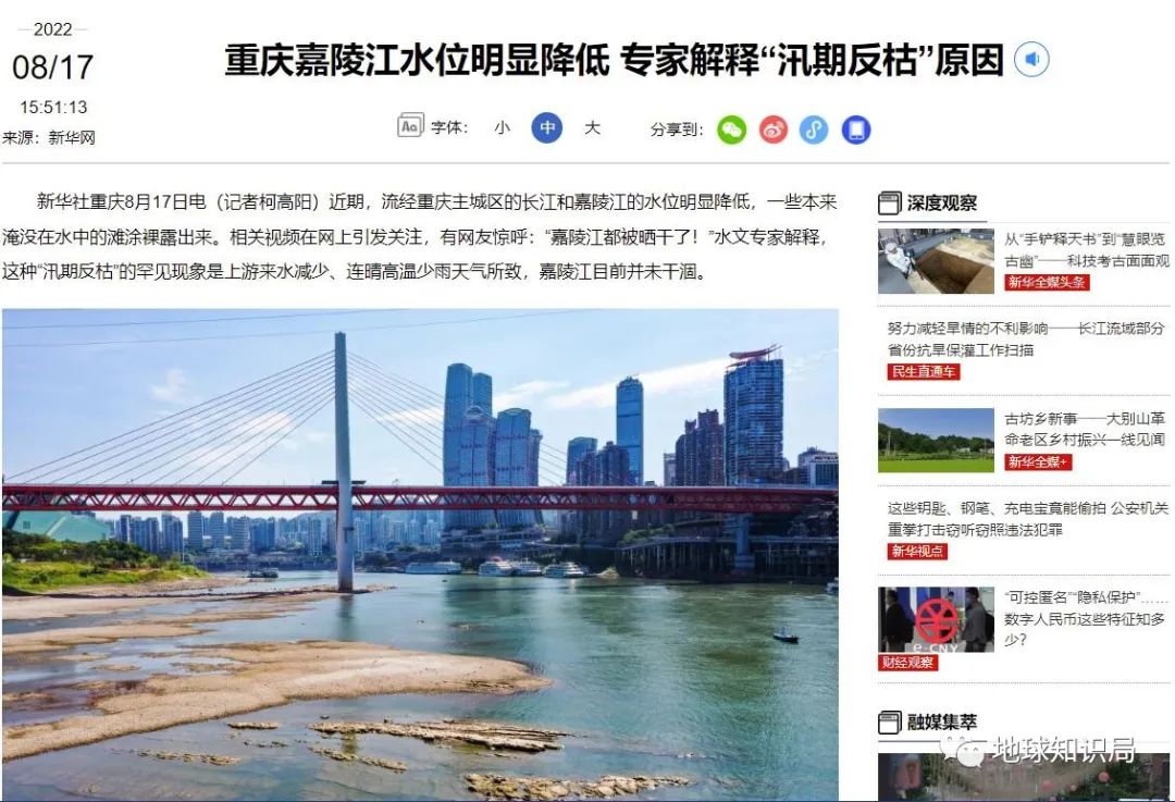
It is also because of the flow of Sanjiang in Hechuan. Usually, the amount of water from the Jialing River Hechuan to the Chaotianmen (Jialing River Estuary) in Chongqing is abundant, and it is often less dry. Therefore, it is rare for the recent drying of the river bed from the Jialing River to the dynasty gate.
Jialingjiang: Brothers, I do it first, you are free
(Figure: Xinhuanet)
After the Yangtze River under the east, the tributaries of Wujiang, Qijiang, Xiangjiang, and Hanjiang brought together. After the Wuhan section of the Yangtze River, the average width of the magnificent river surface reached 1300 meters.
But at this moment, from the Hankou River Beach Park, the wide river surface may be fragmented by the exposed beach.
What is the reason for the Yangtze River to thirst?
From May to October each year is the flood season of the Yangtze River, especially the recent news from the "flood season" news from late July to early August, the main flood season of the Yangtze River. In theory, there are many tributaries in the Yangtze River in the season of rain and heat. The water volume should be stable and rich in summer, but why is it so abnormal this year?
It can be seen how serious the Sichuan Basin is (Figure: Central Meteorological Observatory)
This is to look at the time and space distribution of the source of the water volume of the Yangtze River.
Although there are many tributaries in the Yangtze River and the north -south are intertwined, due to the differences in the latitude, climate and precipitation of the birthplace, the tributaries of Wujiang, Xiangjiang, and Ganjiang River in the Yangtze River from the south bank are the largest. The tributaries of Jiang, Minjiang, Jialing River, and Hanjiang have the largest water volume from 6 to September. Such a tributary convergence makes the flood season of dry flow in the Yangtze River in general.
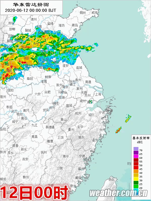
每年5月上旬至6月下旬,随着北半球气温的升高,海陆热力性质差异的作用下,副热带高气压带推进至大约在北纬15°至20°,由此形成了锋面降雨带,即主要Located in the south of the Yangtze River. It can be seen that the "inlaid" of the Mei Rain Belt in previous years was in East China Jianghuai Basin
(Figure: China Weather Network)
In fact, the same is true before June this year. This round of precipitation not only made the south banks of the Yangtze River Basin abundant water, but even brought heavy rain in Jiangxi, Hunan and other provinces, which almost caused flood disasters.
3:500HPA on June 10th
From the next rain to the rain, the extreme weather is really extreme
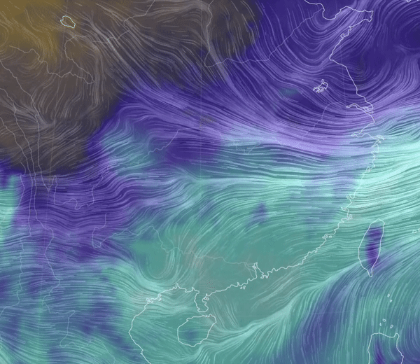
(Figure: Central Meteorological Observatory)
However, in June, when the tributary of the north bank of the Yangtze River was originally the tributary of the Yangtze River to absorb a large range of precipitation, at this time, the west wind band with the north move north of the subtropical high pressure band quickly weakened, which caused the subtropical high -pressure band to quickly cross the Yangtze River dry stream area to the Yangtze River. The Jianghuai area on the north bank of the Yangtze River has lost a large round of precipitation in the north bank of the Yangtze River and the vast number of Jianghuai areas.

When the subtropical high -pressure control is controlled, the air sinks is prevailing, the air temperature increases strong, and due to the small air pressure gradient, the wind is very small, solar radiation can reach the ground more. Long -term heat.
July 7th to 14th
(Reference: Central Meteorological Observatory)
There should be many tributaries on the north coast of the Yangtze River through precipitation, which began to fall into a "lack of water". The Jialing River is one of the representatives.
Their runoffs have not enough runoffs, which have led to a decrease in the water flow of nearly half of the dry flow of the Yangtze River. The decrease in tributary upstream of the Yangtze River is an important reason for the phenomenon of anti -dead phenomenon in this flood season.
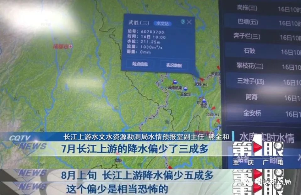
Yangtze River Inch Beach Station and Jialing River Beiyi Station
This year's water level is about 3 meters lower than the same period last year, close to the lowest period of history
(Picture: Chongqing Radio and Television 1)
The subtropical high -pressure band has been hovering in the Jianghuai area, causing the rainy July to rain. Under the heat and rain, the limited surface water evaporation continued to rise, but our production of living water was due The heat is often kept in the high demand stage.
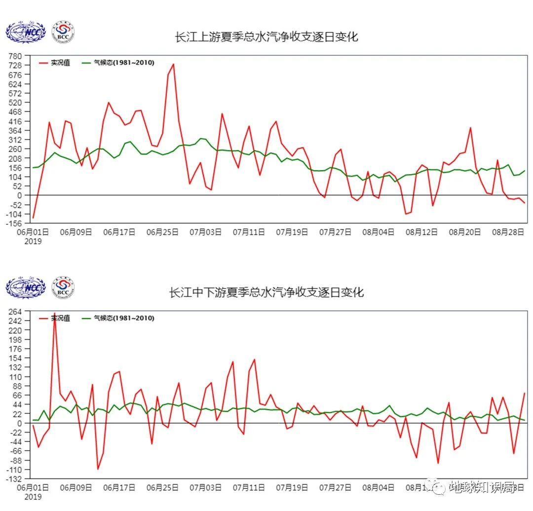
The Yangtze River has been collected since mid -to -late July
(Figure: National Climate Center of China Meteorological Administration)
High temperature and rainy weather, and the imbalance caused by this, make the dry flow of the Yangtze River increasingly lighter and "thin" at the speed of our naked eye.
What are the drought resistance?
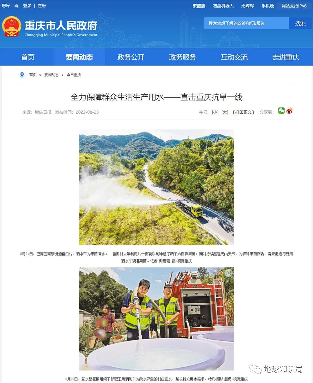
Faced with the continuous high temperature of clear heat, rainfall is generally less, and the severe drought resistance situation has decreased significantly. The Yangtze River Basin has launched a grade IV or III emergency response in Sichuan, Chongqing, Hubei, Hunan, Jiangxi, Anhui and other provinces.
Shao rain adds high temperature and roasted, causing more water dehydration.
Sprinkling vehicles and fire trucks have dispatched to ensure production and living water
The construction of water conservancy facilities and water and drought disasters is a topic of discussing enthusiastically in the drought and floods in recent years.
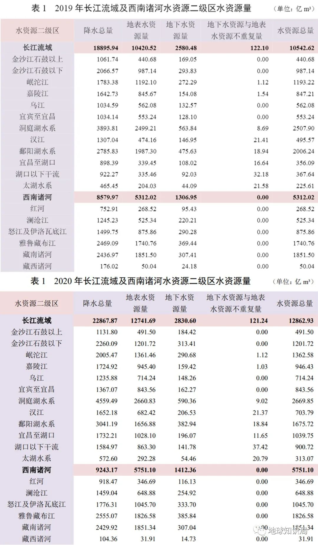
In fact, as far as the Yangtze River Basin and the southwest of the water resources of the river water resources announced in recent years, the increase in surface water resources of the dry flow of the Yangtze River is significantly affected by precipitation in the region.
(Picture: The Yangtze River Water Conservancy Committee)
For example, compared with 2019 and 2019, the Yangtze River Basin has increased by 16.9%in addition to the Poyang Lake water system, and the remaining second -level areas of water resources increased, of which the middle reaches and downstream of the Yangtze River increased by more than 150%. There are also 52.5%to 21.7%increase below Jinsha River stone drum. Such an increase or decrease is completely positively related to the precipitation in all areas of the year.
Since July this year, the Yangtze River Basin precipitation has been at least in history since 1961
No wonder the Yangtze River "bone thin" this year
(Figure: China Meteorological Bureau)
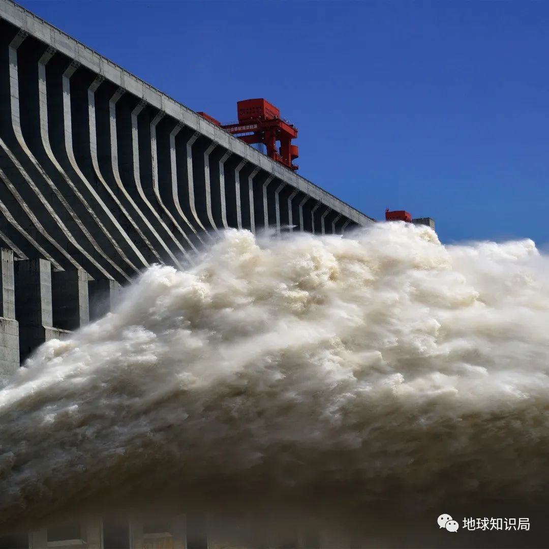
Therefore, the construction of water conservancy facilities does not bring or aggravate the cause of drought. On the contrary, in the current period of anti -drying during the flood season, a large water conservancy hub project such as the Three Gorges Project is an important guarantee for drought resistance and relief.
For the flood season of the river section in the middle and lower reaches of the Yangtze River, in the next few days, the Three Gorges Reservoir will increase the leakage, which will replenish about 500 million cubic meters of water in the middle and lower reaches of the Yangtze River. During the water replenishment of the Three Gorges Reservoir to the middle and lower reaches of the Yangtze River, the lower reaches of the Jinsha River also carried out hydration scheduling at the same time, which can increase water replenishment by about 300 million cubic meters.
Precipitation can prevent flood prevention, less precipitation can resist drought
(Figure: Tuwa Creative)
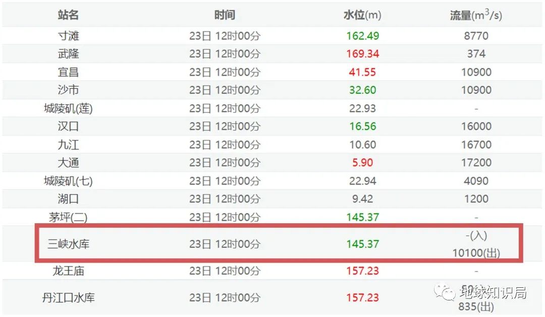
The Three Gorges really worked hard
(Figure: Yangtze River Hydrological Network)
After the flood of the flood in September and October, after the Three Gorges Dam began to storage, and the water level rose to the river to flood, the anti -dead phenomenon of the flood season would be further improved.
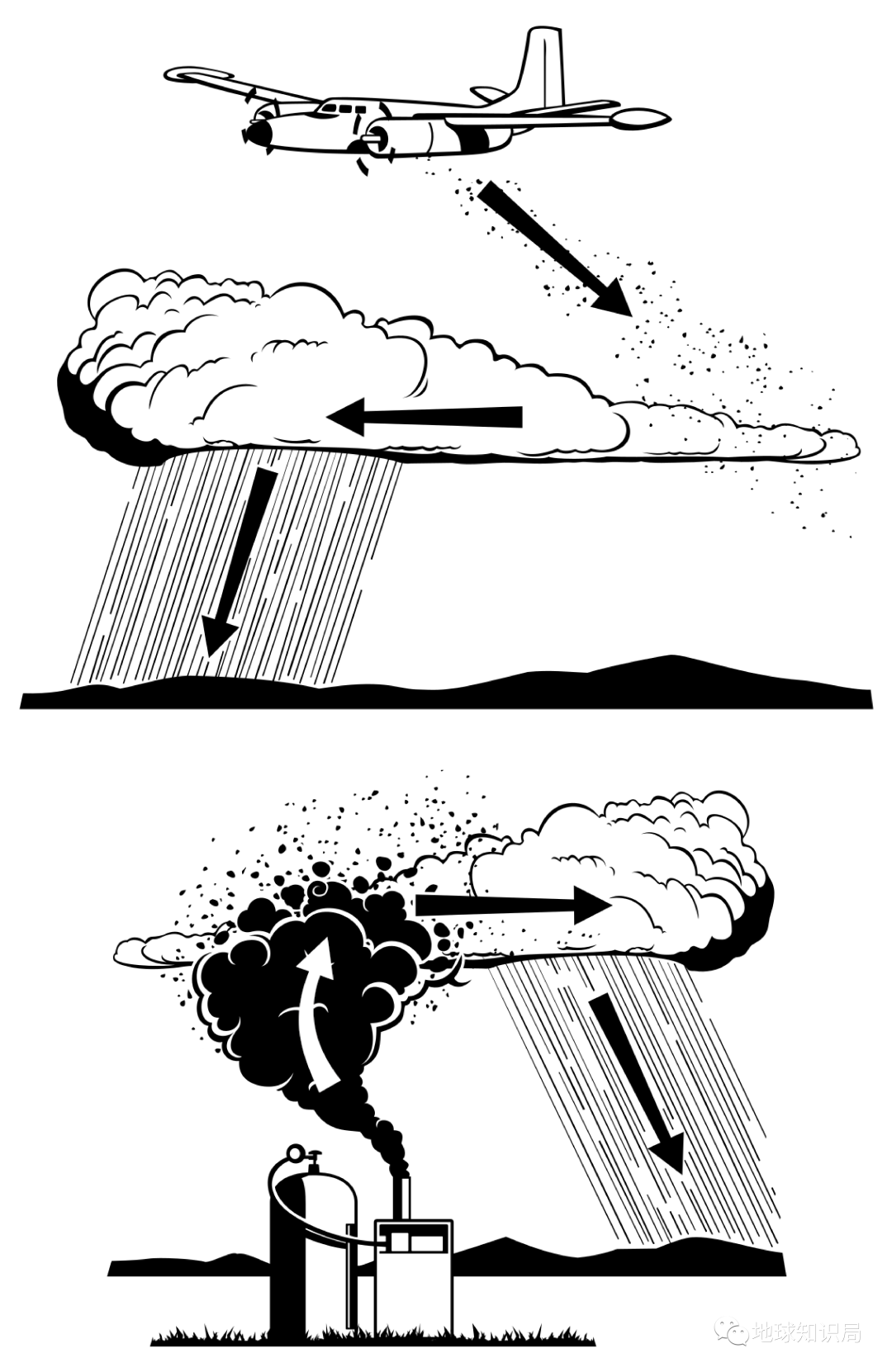
In addition to realizing the time and space of water resources through the water conservancy hub, artificial rainfall is also a good way to prevent heat and drought.
Artificial rainfall is based on factors such as the nature, height, thickness, concentration, scope and other factors of the air clouds, to spread the cold agent, crystallizer, hygroscopic and water mist, etc. to increase the concentration of ice crystals in the clouds and make up for the condensation in the clouds in the clouds. The lack of nuclear, strengthening the clouds and moving in the cloud, promoting the increase in cloud droplets, changing the size, distribution and nature of cloud drops, and accelerating the growth of raindrops, thereby achieving the purpose of increasing precipitation.
(Artificial rainfall principle diagram reference: WMA)
However, artificial rainfall does not want to increase. For example, the amount of sunny clouds is small and the clouds are very thin, so it cannot increase rainfall.
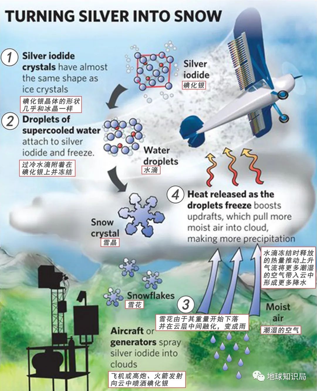
Only the cloud system develops to a certain thickness. This thickness is generally greater than 2 kilometers, and there must be a certain amount of cold water (less than 0 degrees Celsius without freezing water) in the cloud. In this way, the meteorological department can carry the catalyst to the effective parts of the cloud through high guns, rockets, or airplanes to play a role in artificial rainfall. (Different artificial rainfall map maps: wiki)
Under the control of the sinking air flow of the subtropical high pressure, it is not easy to achieve artificial rainfall in the sunny and hot weather in the vast area of the south.
However, with the south of the sun's direct point, the subtropical high pressure cannot be hovering in the Jianghuai area. With its southward movement, a round of heavy rainfall is bound to extinguish this hot summer heat, so that the past and big river in the past In front of my eyes.
Reference materials:
1. The Yangtze River Water Conservancy Committee: "The Barries of Water Resources of the Yangtze River Basin and the Southwest River Water Resources";
2. The Yangtze River Water Conservancy Committee: "Monitoring and Notification of Important Control Section Water Resources in the Yangtze River Basin (June 2022)";
3. Wu Bo, Zhao Qiang, and Ma Fangkai: "Research on the Restore Research on the Revitalization of the Middle and downstream of the Yangtze River", "Environmental Science Guide", No. 5, 2019;
4. "Continue to cool down, rainfall in many places in Jiangsu", "WeChat Jiangsu" in the Propaganda Department of the Jiangsu Provincial Party Committee.
5. "High -temperature red warning" six consecutive hair ", the Yangtze River Basin is now" anti -dead during the flood season ", the Three Gorges Reservoir increases the downstream and downstream hydration," Beijing News.
*The content of this article is provided for the author, which does not represent the position of the Earth Investment Bureau
Cover: shutterstock
- END -
The conditions of the Taiwan Army's military service have changed, and these people have to go to be a soldier

The Speaker of the House of Representatives Pelosi rising the cross -strait situat...
Build a national unified market!Henan's comprehensive cleanup policy "Land Rover"
Without fair competition to award the operator's franchise rights; set discrimination prices, charges, subsidies and other standards or policies for foreign goods; no laws and regulations are clearly...