Middle to heavy rain, local heavy rain!Henan's large -scale autumn rain is coming
Author:Top news Time:2022.08.24


This summer, most parts of our country are abnormal at high temperatures. Typhoon landing in my country has decreased compared with the same period of the same year. However, as the cold air southward, the subtropical high -voltage retreating south retreating south, and the continuity is abnormal and high temperature is defeating, while the Typhoon Saddle, No. 10 and Typhoon 10 of the 10th Typhoon "Scorpion Tiger" on the Northwest Pacific.
"Double Typhoon" to move forward and east -west, will it affect Henan and bring "quenching thirst" to Henan? The reporter from the Dahe News Heb · Yu Video learned from the meteorological department that the impact of the two typhoons on Henan is extremely limited. However, in the next few days, Henan will enter a long -lost rain.
"Double Typhoon" generated in the northwest Pacific Ocean
How much does it affect Henan
Many people have such a feeling that this year's typhoon is less than previous years. According to the statistics of the meteorological department, as of August 22, there were ten typhoons in the Northwest Pacific and the South China Sea. The number of typhoons was relatively small compared to previous years.
This is related to La Na's year. The abnormal tropical ocean circulation caused by La Nina will lead to a decrease in the number of typhoons. However, the number of typhoons is small and does not mean that its influence is small. Whether there will be super typhoons in the future, it also needs to wait for the forecast of all circulation situation.
In recent days, two typhoons have appeared one after another. At present, the "double typhoon" is east and west, and the presence is brushed on the northwest Pacific Ocean. So, what is the progress of the two typhoons?
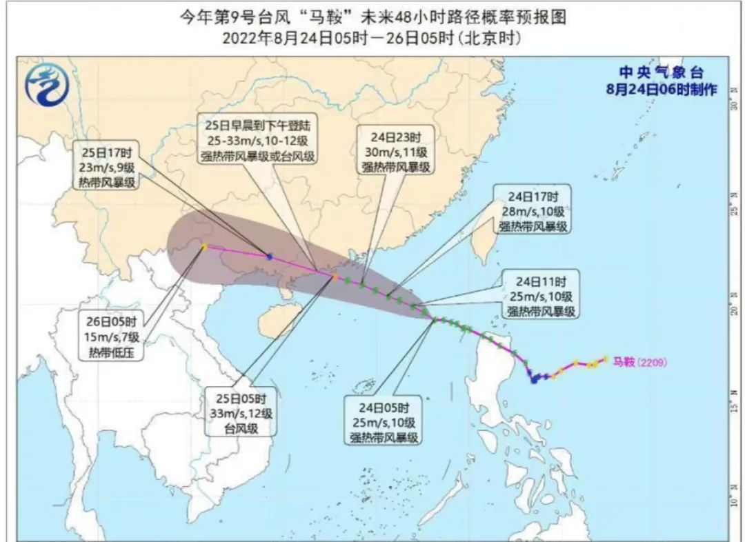
According to the monitoring of the Central Meteorological Observatory, Typhoon No. 9 this year's "saddle" (strong tropical storm) center is located on the north of the South China Sea in the north of the South China Sea (19.2 degrees north latitude and 118.1 degrees east longitude in the south of the south of Yangjiang, Guangdong To. It is expected that "saddle" will move north at a speed of about 25 kilometers per hour, and the intensity will gradually increase. From the morning of the 25th to the afternoon of the afternoon, the intensity will gradually weaken after landing.
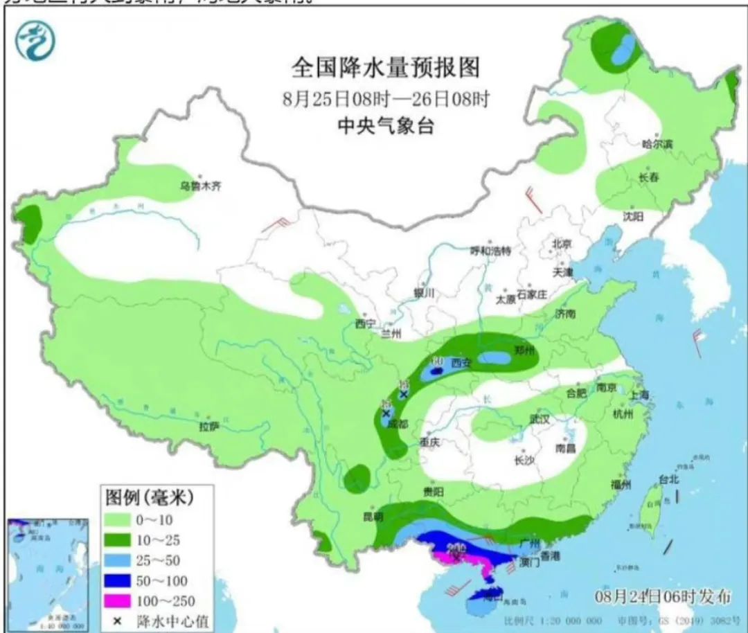
According to analysis, "saddle" will bring heavy rainfall to Hainan, Guangdong, Guangxi and other places. So, will it bring rainfall to Henan? The analysis of experts in the industry depends on the future development trend of typhoons and whether the residual cloud system of typhoons after landing will advance north. At present, it has no effect on Henan.
Typhoon "Scorpion Tiger" No. 10 this year was strengthened from typhoon level to a strong typhoon. At 5 o'clock in the morning, it was located on an ocean surface of about 840 kilometers south of Tokyo, Japan. The speed of about 20 kilometers moves north to the east direction, and the strength is slowly weakened. It will gradually become a green cyclone on the 26th. According to analysis, the "Scorpion Tiger" has no effect on my country in the future.
Typhoon affects Henan
Most of the heavy rainfall brought by the peripheral cloud system
So, what kind of typhoon will affect Henan? What is the main way to affect Henan?
Wang Xinwei, Henan Meteorological Service Center, has done relevant popular science. One way is that the typhoon enters Henan low pressure and directly produces heavy rainfall. Another way is to affect Henan. In comparison, the second way is more common.
Generally speaking, the second day of the typhoon landing, Henan will be influenced by the peripheral cloud system and cause heavy rain. However, when encountering a typhoon with strong intensity and large peripheral cloud system, it may bring heavy rain to Henan that day.
On July 20 last year, Zhengzhou's strong rainfall, I believe everyone is still very impressed. One of the causes is that the typhoon "fireworks" sent a large amount of water vapor to Henan. At the beginning of July this year, Henan encountered a large range of heavy rainstorms, with strong rain, wide range, and large rainfall. This rainfall was affected by the weakening of the "Siam" typhoon weakened north and west wind tanks. From 12:00 on July 4th to 8:00 on 6:00, a large area of heavy rainy weather appeared in southern, east and north.
In the summer of 2018, the typhoon "Capricorn" and "Webia" brought two heavy rainfall to Henan, especially "Wimphya", which brought Zhengzhou for several days of rainfall. Essence These two rainfall are directly affected by the cloud system of typhoon. The rainfall in Henan in the next few days will increase
Put on long sleeves to appreciate autumn wind and autumn rain
This summer, especially since August, Henan has appeared in high temperatures of "long standby". In comparison, most parts of the southern my country have opened an abnormal high temperature mode since early July, high temperature and rain, and drought. However, with the continuous efforts of cold air, the central and eastern regions of my country will cool down from north to south, and high temperature and summer heat in the south will come to an end. High temperatures in Huanghuai, Jianghuai and other places will be the first to relieve. Before weekends, high temperatures in Jiangnan and Jianghan have "ended".
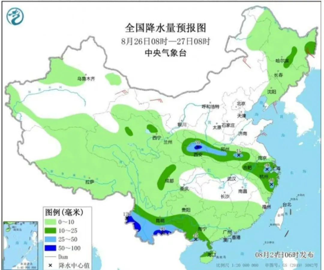
Although the "double typhoon" will not bring rainfall to Henan for the time being, in the next few days, Henan will enter a more than a rainy period since August. According to the forecast of the Central Meteorological Observatory, two days on Wednesday and Thursday, there will be middle to heavy rain in eastern Qinghai, central Gansu, central Ningxia, central and southern Shaanxi, Shanxi, Henan and other places. The rainfall is 20-40 mm.
Coupled with the decrease in temperature and the weather is refreshing. In the next few days, everyone will be able to experience the artistic conception created by autumn wind and autumn rain. According to the forecast of the Henan Meteorological Observatory, there was a precipitation process in our province from the 25th to 27th, and there was a middle to heavy rain in the west.
According to the latest meteorological data analysis, from the 25th to 30th, the Western Pacific subtropical high pressure gradually retreated to the south, and the cold air spread south in the north, affected by it, and the province's multi -time rainfall weather. During the day from the 25th to 27th, some counties and cities in Sanmenxia, Luoyang, Jiyuan and other places have middle to heavy rain, local heavy rain, and are accompanied by strong streaming weather such as short -term heavy precipitation and thunderstorms. Other areas are mainly small to medium rain.
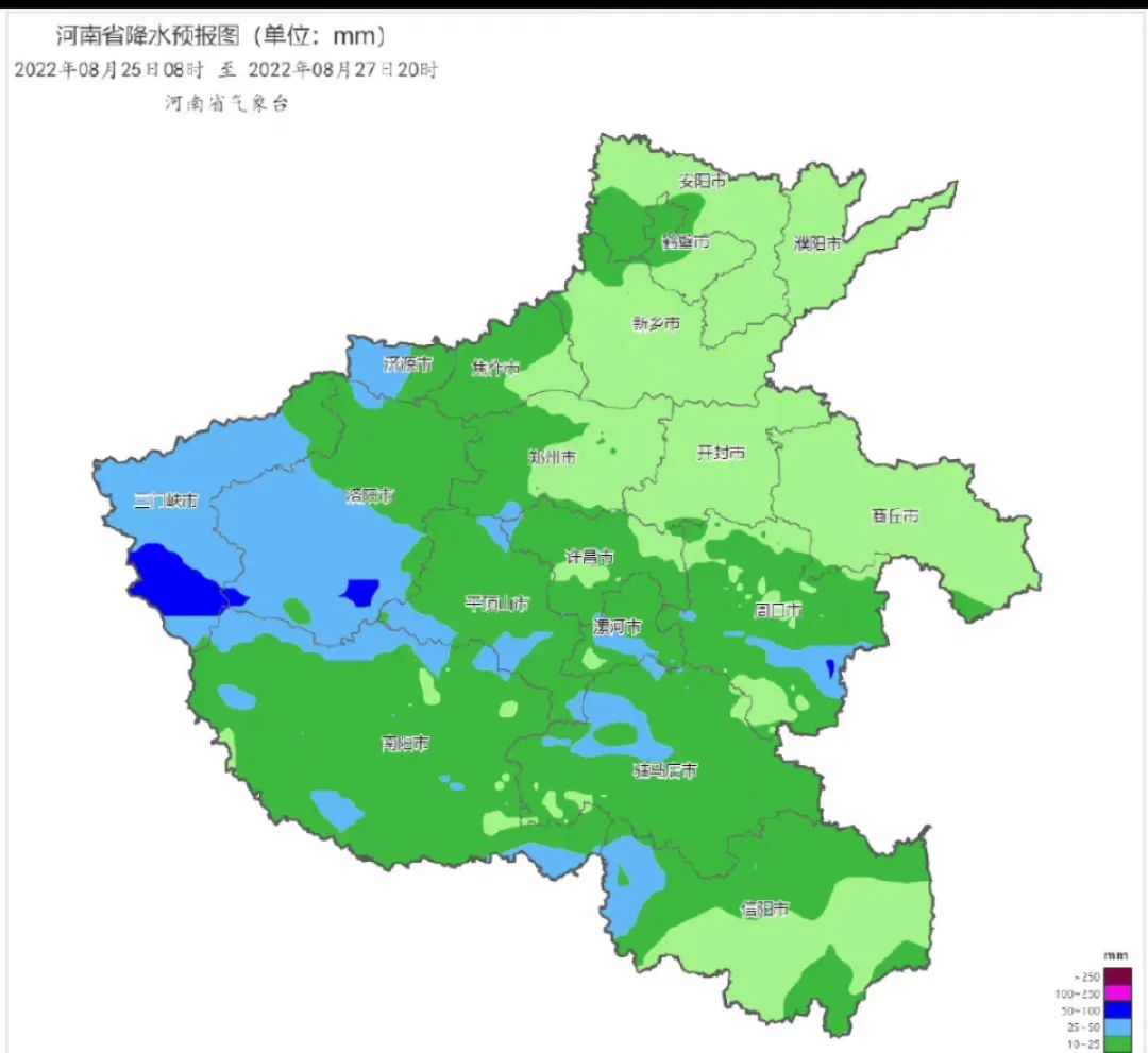
In terms of cumulative precipitation, the west is 10-40 mm, local 50-80 mm, 5-20 mm in other regions, and a minimum of 30 to 50 mm.
According to analysis, this round of precipitation process is beneficial to ease the drought in southwestern Henan and southern Henan, but it is necessary to prevent derivative secondary disasters caused by local short -term intensive precipitation. In addition, the Yiluo River and Sanmenxia Reservoir areas in the Yellow River Basin have a total rainfall of 35-45 millimeters from the 25th to 27th, which need to prevent the adverse effects caused by the upper reaches of Henan.
————————————————————————

Source: Dahe Daily · Yu Video Reporter Liu Ruichao
- END -
Members of the United States visiting Taiwan, the Ministry of National Defense responded!
China Network Military August 15th According to the Ministry of National Defense, a spokesman for the Ministry of National Defense Wu Qian today talked about the visit to Taiwan ’s members of the US
Two departments: By 2025, the shortcomings of the infrastructure
CCTV Beijing August 1 News Recently, the Ministry of Housing and Urban -Rural Deve...