Shencheng continues to end high temperature!49 high -temperature Japanese history is the second!The two typhoon generated one after another!Typhoon No. 9 "saddle" or land in Guangdong
Author:Xinmin Evening News Time:2022.08.24
This summer is already hot
The degree of pervert is rare
The highest temperature record of 150 years
7 40 ℃ +
The only high temperature Grand Slam in mid -August
... ...
Today, it has become the hottest "summer" day
Xujiahui Station's highest temperature reaches 39.7 ℃
This is also the 49th high temperature day this year
To the second highest position in history
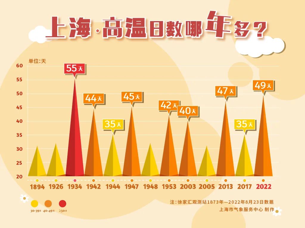
"In the summer" solar terms, the weather in Shanghai slowly turns from heat to cool, and it can be cool sooner or later, but it may not bid farewell to high temperature days. The observation data of the Xujiahui Observation Station in the past 150 years shows that nearly one -third of the year still appears at the "summer" solar terms. Among them, the number of high-temperature days is large, and only 1-2 days appear in some years, and some years are more than 10 days.
Statistics of the weather disaster warning in Shanghai in the past 10 years show that in the "summer" solar terms, the common weather disaster warning in Shanghai is: lightning, heavy rain, high temperature, wind and typhoon. Focus on strong convection weather such as lightning and short -term precipitation.
Although hot today
But the cold air has sneaked into the sub -surrounding circle secretly
The increase in cloud system in Shanghai afternoon
Local convection weather appears
Release lightning, heavy rain, and wind warning signals successively

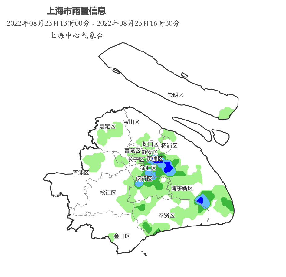
Affected by rainfall
The amount of rain reduction at 13:30 to 16:30
Main precipitation appears
Central urban area, Pudong, Minhang, Fengxian
The old west gate of the central city area 92.0 mm is the largest
Shanghai time
After the rain is sunny
A "Rainbow Bridge" appears in Shanghai Skyrim
The beauty is always fleeting
Rainbow appeared in the sky for about 10 minutes
Fortunately, do you see it?
Shanghai time

Picture source: Surging News


Picture source: netizens or see watermarks
Starting from the 24th, it was affected by the spread of weak cold air in the north
There are more rain or thunderstorms in Shanghai
Continuous high temperature ends
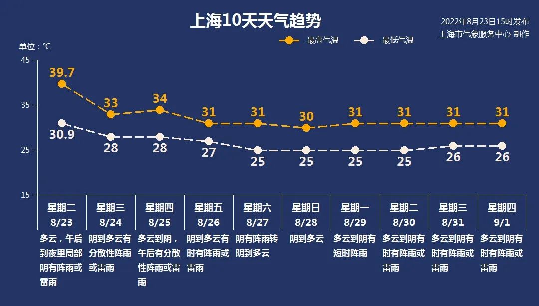
Tomorrow (24th) cloudy to cloudy or decentralized showers, temperatures of 28 ~ 33 ° C, northeast wind 4 ~ 5 levels, 8 ~ 10 gusts north when thunderstorms, and the relative humidity of the air is 90%to 50%.

Affected by the cold and cold air from 25 to 26, there was a relatively obvious rainfall weather in Shanghai, accompanied by lightning and short -term heavy precipitation.
The main precipitation period appears from the afternoon to 26th from the 25th, and the rainfall distribution is unevenly distributed, and the maximum hourly rain is 30 to 50 mm. The temperature is between 27 and 34 ° C.
After the 26th, it mainly focuses on cloudy to overcast, sometimes there are rain or thunderstorms. The minimum temperature is 25 ~ 26 ° C, and the body feel is comfortable in the morning and evening, and the highest is 30 ~ 31 ° C during the day. Compared with this period of high temperature and heat, happiness is more than a little bit ~
Where is the cold air?
There are places in the south to cool over 10 ℃
At 14:00 today, the cold air striker has arrived in Jiangsu and central Anhui. Affected by it, today, compared with southern Shaanxi, Henan, southern Shandong, Hubei, Anhui, Jiangsu, and yesterday, there have been different degrees of cooling, especially in southern Henan, northern Anhui, and northern Jiangsu. Essence
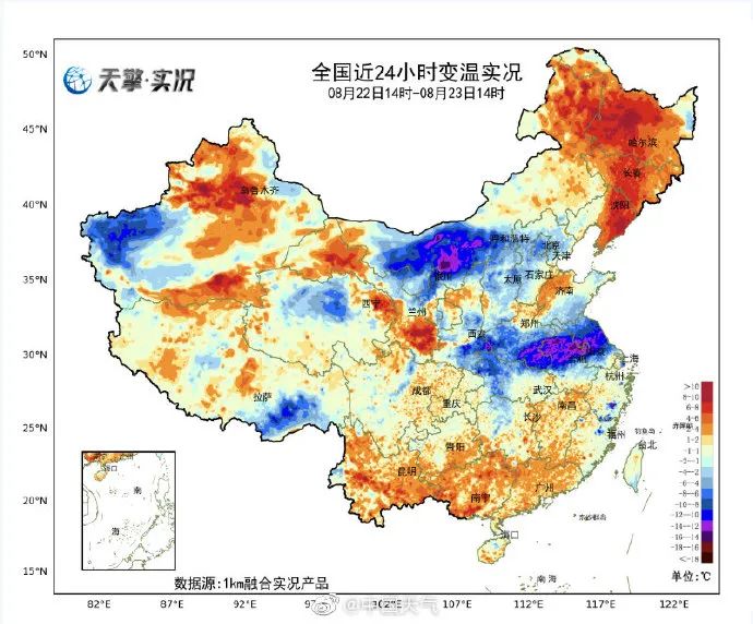
Like Hefei yesterday, the highest was 38.3 ° C yesterday, and today at 14:26.5 ° C, the decrease was close to 12 ° C; Nanjing yesterday was 38.3 ° C yesterday, and today at 14:29.5 ° C, the drop is close to 10 ° C.
Jiangsu has dropped significantly from the 24th
The cooling can reach 6 ~ 8 ℃
@Weather Reply:
The free shipping area will withdraw from the high temperature group to chat ~

From the 28th
Middle and eastern Sichuan, central and northern Chongqing and other places
Obvious rain
The Central Meteorological Observatory released the next week of rain feelings:
The rain in the north is mainly concentrated in the eastern Qinghai, southern Gansu, Shaanxi, Shanxi, Henan and other places.
From the night of August 24th to the 26th, due to the affected by typhoon saddle, there were heavy rains in western and coastal areas, Guangxi, southern Guizhou, and northeast Yunnan, and heavy rainstorms.
From the 26th, the West China region gradually entered the rainstorm, and gradually extended to the south from central and southern Shaanxi. From the current forecast conclusion, from the 28th, the rainy of the central and eastern parts of Chongqing, the central and northern parts of Chongqing. Essence

China Meteorological Administration
Display artificial rainfall aircraft to arrive in Chongqing
In order to support the drought resistance of Chongqing, the China Meteorological Administration dispatched a high -performance aircraft to help Chongqing's rainfall and drought resistance, and sent experts to conduct guidance of rain increase operations.
The plane arrived in Chongqing at 4 pm on the 23rd. Only when the precipitation weather system entered Chongqing, it would jointly "attack" with 107 high guns and 99 rockets in Chongqing City to rain.

The two typhoon generated one after another!
Typhoon No. 9 "saddle" or land in Guangdong
South China will welcome strong wind and rain
At present, typhoons at sea are beginning to be active. Yesterday, Typhoon No. 9 "saddle" and Typhoon 10 of this year were generated. Among them, "saddle" will land on the 25th of the area on the 25th. Affecting the typhoon in my country. Affected by it, from the 23rd to 25th, there will be obvious wind and rainy weather in the southern sea area and the coast of South China. In the future, "Scorpion Tiger" has no impact on our country.
At 11 noon yesterday, the typhoon "saddle" was generated at the 9th of this year, and the intensity was a tropical storm. Immediately after, Typhoon "Scorpion Tiger" was generated at 14:00. Zhang Juan, a meteorological analyst of China Weather Network, said that at present, the cloud system of "saddle" is asymmetric, the center is exposed, and the convection is mainly developing on the south side of the heart. The possibility of reaching the typhoon level, from generation to ending mainly affects South China, has a concentrated impact on the storms brought by land. The "Scorpion Tiger" cloud system is relatively compact, but it is far from my country and has no impact on our country in the future. The Central Meteorological Observatory predicts that the "saddle" will move west at a speed of 5-10 kilometers per hour. After the evening of the 22nd, it will move to the northwest. It will move into the northeast of the South China Sea on the early morning of the 24th and gradually approach the Guangdong coastal closer to the coast of Guangdong. , The intensity continues to enhance, the strongest can reach the strong tropical storm (level 10-11, 25-30 meters/s), and will land on the above coast during the day on the 25th (23-28 meters/s, level 9-10, Tropical storm or strong tropical storm level). After landing, the intensity gradually weakened.
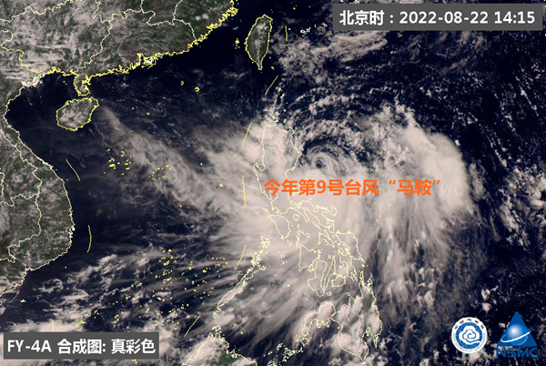
"Saddle" will be a typhoon that affects our country. Starting on the night of August 23, wind power in the southeast waters of my country will begin to gradually enhance. From 23rd to 25th, the bus Strait, the East Ocean, the Taiwan Strait, the northern part of the South China Sea, the coast of Taiwan, the coast of Fujian, and the Guangdong coast will appear 6-8 strong winds. Among them, there will be 9 in some waters in the buses and northeast of the South China Sea. -10 Grand Wind, the wind and regions passed by the Typhoon Center can reach level 10-11, and the gusts are 12-13.
Zhang Juan said that with the advent of "saddle", the rainstorm in Guangdong has increased from the 24th. On the 25th, there will be heavy rain or heavy rain in the Pearl River Estuary of Guangdong and west. Land heavy rain. The above -mentioned regions need to strengthen the prevention of heavy rainfall may cause urban and rural floods, floods, geological disasters, and floods of small and medium rivers. At the same time, strong streaming weather hazards such as land mines and heavy winds are prevented. Testing should pay attention to windproof and rain.
As of now, five typhoons have been generated in the Northwest Pacific Ocean and the South China Sea in August this year, which is close to the average (5.7) annual (5.7), and the overall strength is average.
Statistics show that August per year was the month when typhoons were generated the most. From 1949 to 2021, 415 typhoons were generated in August and the South China Sea in August, with an average of 5.7 typhoons generated each year.

The typhoon that landed in our country in August has the characteristics of the second largest number, the second strength, the widely landing face, the variety of paths, and the increase in the number of typhoons in the north. Throughout 1949 to 2021, there were 95 typhoons that landed in our country in August 73. From the intensity when they were landing in my country for the first time, 12 of them were strong typhoons, 5 were super typhoon, accounting for 17.9 to 17.9 %. In addition to the coastal provinces (cities, districts) except Hebei and Tianjin, China has become the land of Typhoon August from Guangxi to Liaoning. Among them, the most often landed place is Guangdong, followed by Taiwan and Fujian.
September is still a period of active typhoon. The southeast coastal areas should pay attention to the impact of heavy rain, wind and storm trends brought by typhoons on the coastal regions of ships, fishery farming, ports and industrial and mining enterprises, and effectively do a good job of typhoons.
Xinmin Evening News (XMWB1929) Comprehensive Shanghai Early Warning, China Weather, Central Meteorological Observatory, Surging News
Video production: Situ Ruochen
Edit: Shi Yu
Xinmin Evening News Xinmin Evening News is a newspaper with temperature, strength, dimension, and scale. It started in Nanjing in 1929. It is based on Shanghai in the next long term and faces the whole country. Looking at the world. It is the earliest newspaper in Mainland China and has been published continuously so far, with a daily circulation of 1 million copies.

757 original content
the public
- END -
All open!Free

The temperature has continued to rise recentlyMore than 1,500 communities in Wuhan...
Yin Zhao raised to Qingcheng, fresh supervision of flood prevention and rescue, and mass resettlement work

From June 22nd to 23rd, Yin Zhaoju, Secretary of the Municipal Party Committee and...