Double typhoon generated, Quanzhou weather ...
Author:Quanzhou Evening News Time:2022.08.25

Notice!
Typhoon No. 9 "saddle"
Typhoon No. 10 "Scorpion Tiger"
Both generation! Dance of dance!
Quanzhou temperature continues to rise!

"Saddle" and "Scorpion Tiger" generation! Dance of dance!
According to the Central Meteorological Observatory
Typhoon "Scorpion Tiger" this year! Intersection
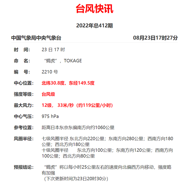
Typhoon "Scorpion Tiger" (tropical storm level; English name: Tokage; Source: Japan; Name: Scorpion Tiger Constellation) was generated at the east at noon on the 22nd. On the ocean surface of about 1650 kilometers southeast of Japan, 25.0 degrees north latitude, 151.6 degrees east longitude, 8th (18 meters/s), 998 hundred Pache, and the seven-level wind circulation is 100-250 kilometers. It is expected that the "Scorpion Tiger" will move north to the west at a speed of 25-30 kilometers per hour, and move to the northeast on the 24th. The intensity is not great. On the 26th, it is transformed into a temperate cyclone. In the future, "Scorpion Tiger" has no impact on our country.
Just before
Typhoon No. 9 this year is generated!
(Tropical Storm)
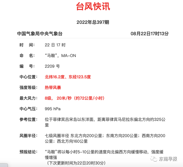
The tropical tropical low pressure on the southern ocean on the Philippines has been strengthened to the 9th Typhoon "saddle" (tropical storm, English name: MA-ON; name: Hong Kong, China; Name: Shanfeng name). According to the latest news from@: Typhoon No. 9 this year "saddling" this year (23rd) was strengthened from tropical storm to a strong tropical storm. At 8 o'clock in the morning, it was located in the northwest Pacific Ocean about 345 kilometers northeast of Manila, Philippines. On the surface is 17.0 degrees north latitude and 123.0 degrees east longitude. The maximum wind near the center is 10 levels (25 meters/s), the lowest air pressure in the center is 985 hundred Pache, and the seven-level wind ring radius is 180-240 kilometers. It is expected that "saddle" will move northwest at a speed of about 25 kilometers per hour. The strength changes are not great or slightly enhanced. After moving into the northeast of the South China Sea tomorrow morning, it will gradually approach the coast of Guangdong. During the day, the coastal landing from Shanwei, Guangdong (23-30 meters/s, level 9-11, tropical storm or strong tropical storm level) has gradually weakened after landing.
According to meteorological experts @Weatherman Xinxin--
At noon on the 22nd, the Japan Meteorological Agency upgraded two low -voltage upgrades. The low pressure on the east of the Philippines became Typhoon No. 9, and the low pressure of the Pacific hinterland became Typhoon No. 10. These two typhoons have appeared together in the past, and the strong saddle that year swallowed the weak scorpion tiger. These two typhoons have taken their own ways this year. The scorpion and tiger turn around the north, which has no impact on our country. Saddle is highly likely to land in Guangdong on the 25th.
Southeast and southern waters of my country
Will be affected by typhoons
The Marine Weather Bulletin I. The weather in the sea is active on the 21st to 02:00 on the 21st to 22nd. 2. Key weather forecasts in offshore waters 1. There will be 6-7 gestures in the northern waters of my country to 22nd night to the night of the 23rd. Northern wind. 2. The southeast and southern waters of my country will be affected by typhoons during the day to the night of the 24th. Among them, there will be 9-10 levels and gusts of 11-12 gusts in the waters of the Bus Strait and the northeast of the South China Sea.
Come here
Will Quanzhou be affected?
Fujian Meteorological Observatory
Yesterday at 16:00, the "Typhoon Warning Class IV" was released
According to the "Flood and Typhoon Emergency Plan for Flood Control in Fujian Province", the Fujian Provincial Defense Index decided to launch a typhoon anti -level response response at 16:00 on August 22. The notice requires that the defense fingers of the coastal districts and cities (Pingtan Comprehensive Experimental Zone) and the relevant departments are closely paying close attention to the follow -up development trend of "saddling", and timely preventive response work.
According to the forecast of the Provincial Meteorological Observatory, due to its influence, from noon from noon to the morning of the 25th, the windpur of Taiwan's shallow beach fishing farm can reach level 8 -9 and level 10 -11; from the evening of the 24th to the morning of the 25th, the fishing ground and the southern coast of the southern Fujian The maximum wind power can reach level 7 -8, and gusts 9 -10; on the 24th, the maximum winding of Fujian fishing grounds and the central coastal wind power can reach level 6 -7, and gust -9 levels. In terms of precipitation, on the 24th, there were some shower or thunderstorms in the coastal areas of our province, with local heavy rain. On the 25th, there were showers or thunderstorms in the province. There were medium rain to heavy rain in the south, and local heavy rain. The high temperature in our province would be significantly relieved.

good news!
Typhoon remote air offer and rain
Starting from the 25th,
Typhoon No. 9 this year's "saddle" will be delivered to the rain remotely,
The high temperature in our province will be significantly relieved.
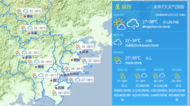
It is expected to be two days today,
Most town streets in Quanzhou City have a maximum temperature of 35 ° C,
Some towns and villages reach 37 ° C or more,
Local towns and towns continued to rise towards a high temperature of 40 ° C.
During the same period, Quanzhou was dominated by cloudy weather,
There will also be shower or thunderstorms in some areas in the afternoon.
With the strong tropical high -pressure strong west, Quanzhou's high temperature returned on the 21st and 22nd. On the 22nd, the maximum temperature of 25 towns and villages in the city exceeded 40 ° C. At 14:15 on the 22nd, the highest temperature of the Nan'an Meteorological Observation Station was 40.3 ° C or even broke the historical pole.value.With the maintenance of the auxiliary height, high temperature weather will continue. It is expected that the maximum temperature of most town streets in Quanzhou City from 22-25 can reach above 35 ° C, and some towns and towns can reach 37 ° C.News from the Central Meteorological Observatory, the large -scale high temperature in the south will gradually ease after the second half of this week, but before the cold air comes, the high temperature will continue.The weather is hot, everyone pays attention to sun protection!

Source: CCTV News, Central Meteorological Observatory, Fujian Meteorological, Quanzhou Meteorological Observatory and other reporters: Wu Zhiming Editor: Zheng Ruiqing review: Jiang Xiaoyuan
- END -
Night Check the "Wine" driver!Jining Traffic Police launched a special rectification operation for drunk driving illegal acts

Qilu.com · Lightning News July 3rd News from July 1st to the early morning of Jul...
Do you know about graduating from "Plus Ears"?

Another graduation seasonGraduates wear school uniforms in laughterEnjoy the gradu...