"Out of" today 丨 The weather is still a bit hot
Author:Sichuan Provincial Meteorologi Time:2022.08.25

25
Thursday
August 2022
Lunar calendar July 28th

Today, I finally##! Hope the weather after being out can be better for us! #Is finally over#
Retrospective
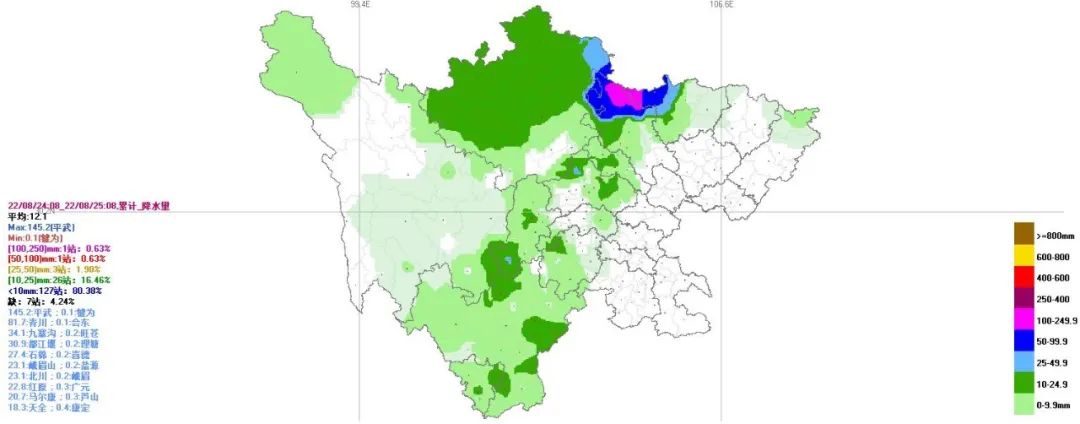
(Cumulative rainfall on the 24th to 08:00 on the 24th)
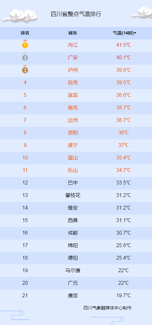
Yesterday from 08:00 until today at 08:00, there were showers or thunderstorms in the western Sichuan Plateau and the west of the basin. In some places, heavy rain, local heavy rains, heavy rain in Guangyuan, and the rest of the basin were sunny. The lowest temperature in the basin is 27 to 30 degrees, the highest temperature, 37 to 40 degrees west, and 40 to 43 degrees in the rest.
At 14:00, the temperature is active
In the morning, it is mainly cloudy and sultry. There will be decentralized showers or thunderstorms from the afternoon to night, and it is accompanied by a short -term heavy precipitation and short -term gangue.
Weather forecast in the next 24 hours
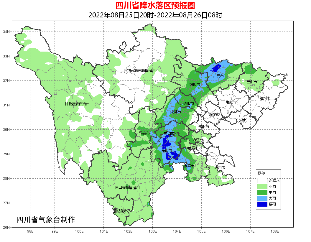
Tonight: Dazhou, Guang'an, Nanchong, Suining, Ziyang 5 cities, and the clouds in the northern part of Luzhou are clear. The remaining places in the basin are cloudy and cloudy or thunderstorms. It is accompanied by short -term gamborn winds during thunderstorms. ; Western Sichuan Plateau and Clouds in Panxi have scattered shower or thunderstorms.
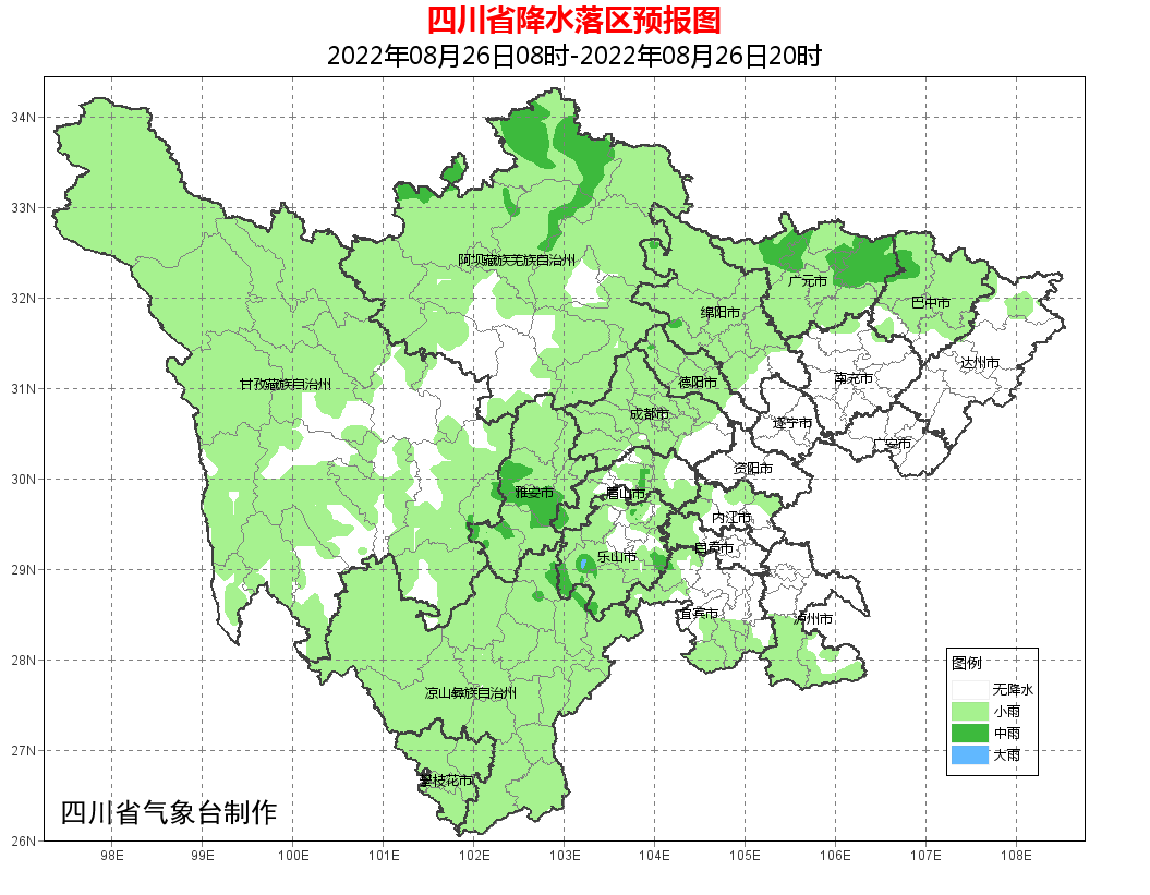
Tomorrow during the day: Dazhou, Guang'an, Nanchong, Suining, Ziyang 5 and Yibin, and the northern part of the city of Luzhou, there are cloudy and cloudy in the rest of the basin. There are scattered shower or thunderstorms in the clouds of clouds in Panxi. Among them, there are medium rain in the northern part of Aba Prefecture.
Within 24 hours, the lowest temperature in the basin: 23 ~ 25 ° C in the west, and the rest of the place is 26 ~ 28 ° C; the highest temperature: 32 ~ 35 ° C in the west, and the rest of the place 36 ~ 39 ° C.
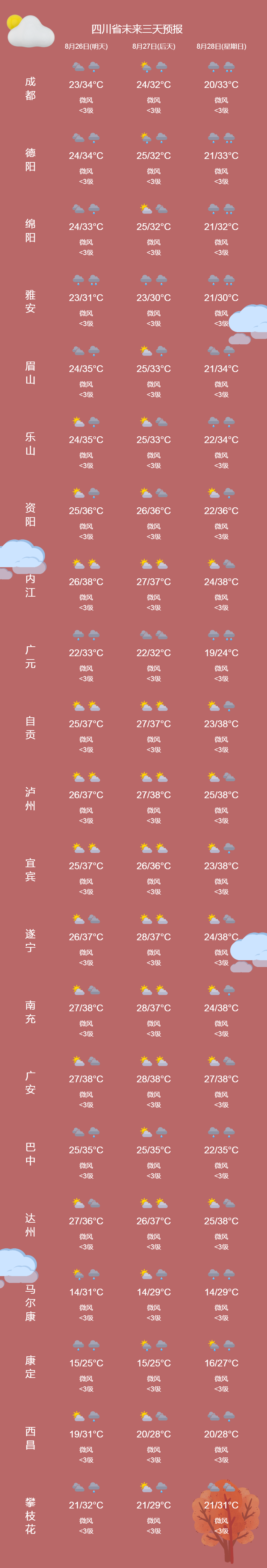
Main cities 3 days forecast
Weather trend
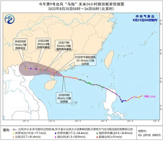
In the next two days, due to the "saddle" of Typhoon No. 9 this year, there will be heavy rains in parts of South China coast, Yunnan and other places, heavy rain or heavy rain.
The Central Meteorological ORC issued a typhoon orange warning at 06:00 on August 25. Typhoon No. 9 this year has been strengthened from a strong tropical storm to a typhoon at night yesterday (24th). At 5 o'clock today (25th), it is located in the northern part of the South China Sea, about 210 kilometers south of Zhanjiang, Guangdong in the north of the South China Sea. On the sea, the maximum wind near the center is 12 levels (35 meters/second), the lowest air pressure in the center is 970 hundred Pache, the seventh-level wind ring radius is 200-240 kilometers, the tenth-level wind circle radius is 100-120 kilometers, and the 12th-level wind circles The radius is 40-60 kilometers.
It is expected that the "saddle" will move north to north at a speed of about 30 kilometers per hour, and the intensity will not change much. It will land on the coast of Yangxi to Leizhou around the Yangtze of Leizhou around noon today (33-35 meters/s, 12, 12, 12, 12, 12, 12 Level, typhoon level), the intensity gradually weakened after landing (see Figure 1). Affected by it, from 08:00 to 08:00 on the 25th, the central and northern waters, Qiongzhou Strait, Beibu Gulf, Xisha Islands near the waters of Zhongsha Islands, the coast of the central and western parts of Guangdong, the coast of Guangxi, and the coast of Hainan Island will be available. Grade 6-9, the wind in the nearby waters or regions passed by the "saddle" center can reach level 10-12, and the gusts are 13-14.
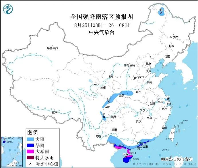
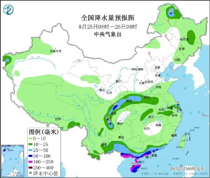
The Central Meteorological Observatory continued to issue heavy rain blue warning at 06:00 on August 25. It is expected that from 08:00 on August 25th to 08:00 on the 26th, the coast and west of the eastern part of Guangdong, south of Guangxi, Hainan Island, and western Sichuan Basin, southeast Gansu, southern Shaanxi, western Henan and other places are as heavy as heavy rain. Among them, southwestern Guangdong There are heavy rains along the coast of the coast, the southwestern coast of Guangxi, and northern Hainan Island, and there are heavy rainstorms (250-300 mm). The above -mentioned areas are accompanied by short -term heavy precipitation (the maximum hourly rainfall is 30 to 50 mm, and the local area can exceed 60 mm), and there are strong convective weather such as thunderstorms in the local area (see Figure 2).
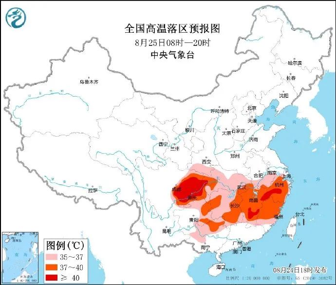
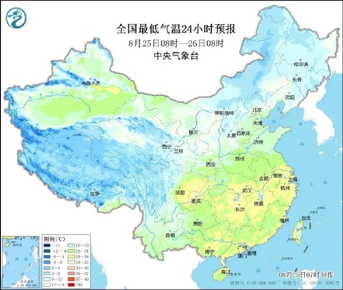
During the day on August 25, Sichuan Basin, Chongqing, eastern and northern Guizhou, south of Shaanxi, Hubei, southern Anhui, Hunan, Jiangxi, Zhejiang, Fujian, and north of Guangxi have 35-39 ℃ high temperature weather. The highest temperature in parts of Chongqing, eastern and southern Jiangxi, and central Zhejiang can reach 40 ° C (see Figure 3). The Central Meteorological Observatory continued to issue a high -temperature orange warning at 06:00 on August 25.
In the next week, the weather in the eastern part of Northwest China, western North China, Huanghuai and other places will be used in multiple precipitation weather. Among them, on the 25th to 27th, there will be middle to heavy rains in eastern Qinghai, central Gansu, Ningxia, Shaanxi, southern Shanxi, and Henan. Millimeters; in addition, there will be thunderstorms or hail weather in eastern Qinghai, eastern Gansu.
From 27-30, the central and eastern Gansu, southern Ningxia, most of Shaanxi, south of Shanxi, northern Sichuan Basin, west, Henan, northern Jiangsu and Anhui, eastern Guizhou and other places have heavy rain and heavy rainstorms.
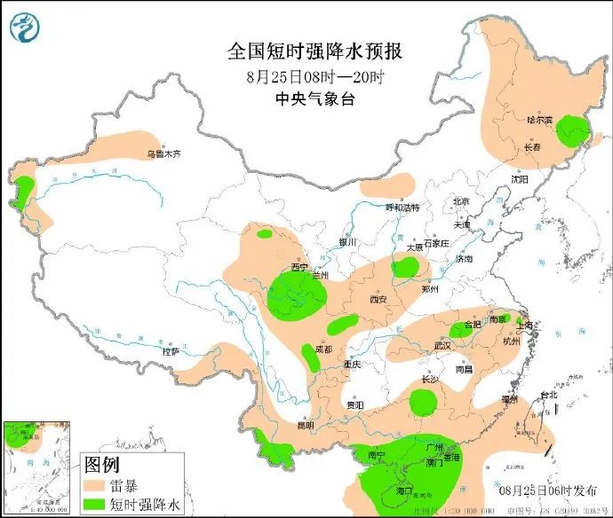
From 08:00 on August 25th to 08:00 on the 26th, the coast and west of the eastern part of Guangdong, south of Guangxi, Hainan Island, and western Sichuan Basin, southeast Gansu, south of Shaanxi, western Henan and other places were as heavy as heavy rain. Among them, the coast of the southwestern part of Guangdong There are heavy rain in parts of the southwestern coast of Guangxi, northern Hainan Island, and other areas, and there are heavy rainstorms (250-300 mm). There are 4 to 6 winds in the northeast of Inner Mongolia and the central parts, eastern Xinjiang and other areas (see Figure 4). The northwest of the South China Sea will have 10-11 levels, the 12th level of gusts will be reduced to 7-8, and the southern wind of level 9 will be reduced. Gust -level eight -level southwind. Forest grassland fire risk meteorological level forecast
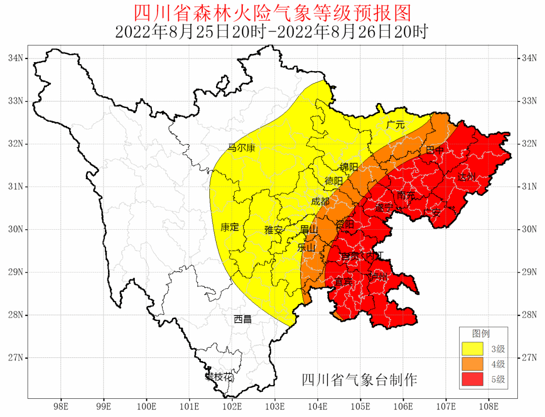
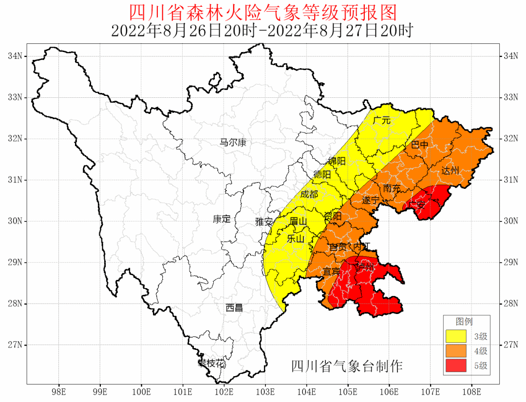
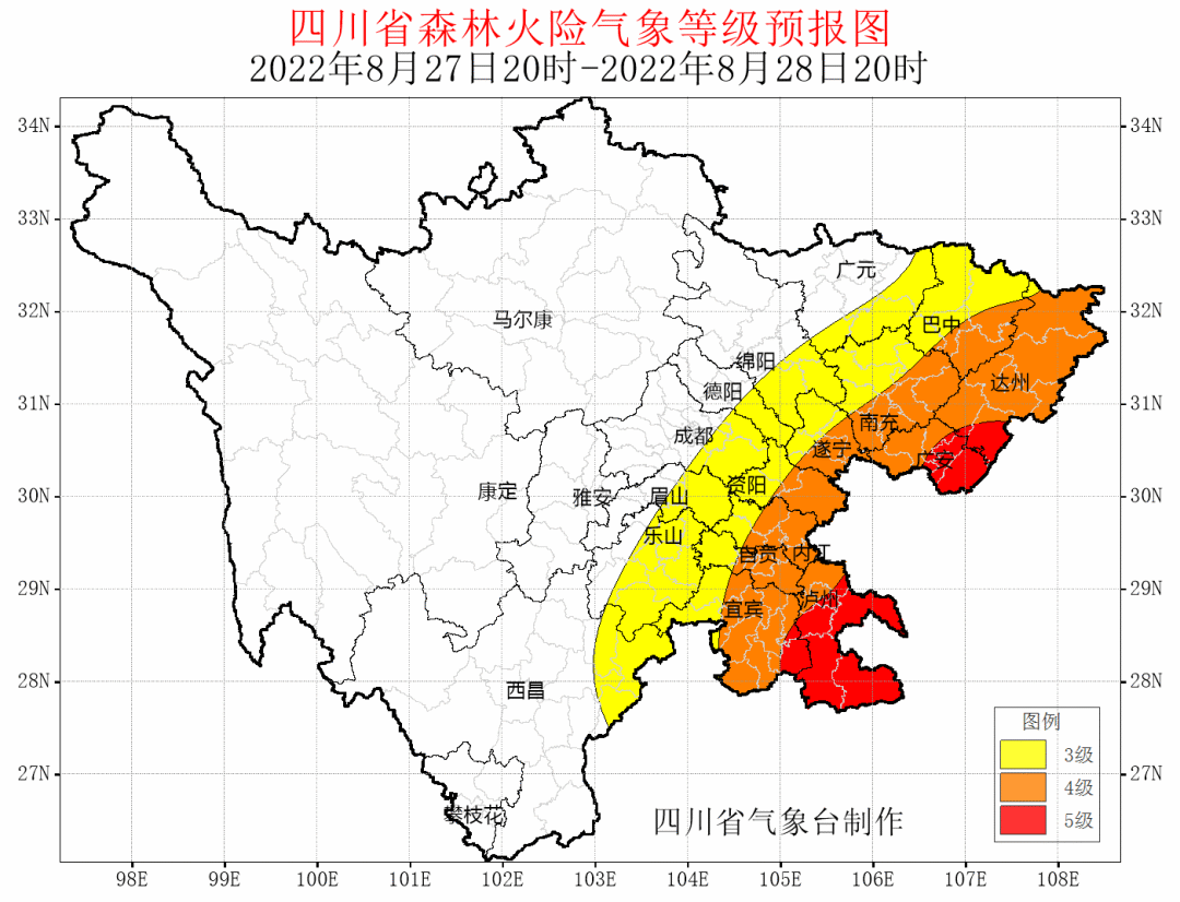
According to the latest meteorological data analysis: 20:00 on August 25th, 20:00 on 20:00, the western forest fire risk meteorological grade of the western basin of the basin, the remaining forest fire risk meteorological grades of the remaining parts of the basin; 4 to 5; August 26th, 20th to 28th At 20 o'clock, the northeast, central and southern forest fire danger weather levels of the basin are 4, and the local area can reach level 5. Relevant states are requested to strengthen the management of fire sources and do a good job of forest fire prevention.
Summer damp heat is vigilant, common skin diseases
Click to read the original text to learn more about meteorological information


- END -
The balance of various loans from local currency increased by 3.6 trillion yuan year -on -year increased by 10.3% year -on -year
Shanxi Evening News (Reporter Zhang Zhen) On July 28, the Shanxi Provincial Government News Office held a press conference to introduce the situation related to financial statistics and financial supp
"Trade Union+Law Firm", support employees to "protect the umbrella of love rights and interests"

In order to further strengthen the construction of employee rights protection mech...