Western Inner Mongolia continues the weather in the middle and eastern parts of the high temperature and the strong opposite of the strong convection, Hohhot ...
Author:Hohhot Evening News Time:2022.06.18
Weather review
yesterday
Hohhot's friends are blew up by the wind, right?
The large wind speed of the capital city reached 24.8 meters/s
For the tenth level
That style is like a hard -to -tie Mustang
Range in the city
Straight and dark, chaotic ...
This is the power of strong convection
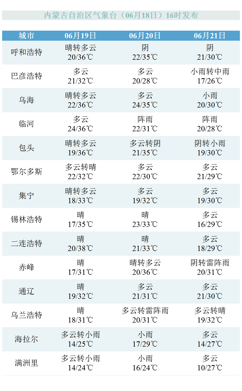
Hohhot weather forecast:
On June 19th (Sunday), cloudy turns overcast. The maximum temperature is 36 degrees Celsius, and the lowest temperature is 22 degrees Celsius.
Cold index: less hair, low probability of cold, avoid being in the air -conditioned house for a long time.
Exercise index: more suitable, please reduce exercise time and reduce exercise intensity.
Allergy index: not easy to post, except for special constitutions, do not need to worry about allergies.
Dress index: heat, suitable for summer clothing such as T -shirts, short coats.
Car washing index: better weather, suitable for scrubbing.
UV index: very strong, wipe SPF20 or more, PA ++ skin care products, avoid strong light.
GO
Popular science time
Strong convection weather refers to the disaster -stricken weather that occurs suddenly and more severe and destructive. When it appears, it often flashs and thunderous, wind and rain. Thunderstorms, thunderstorms, hail, tornado, thunderstorms, and short -term heavy precipitation are strong convection weather.
Inner Mongolia is vast, no matter what time it may occur, and the types of strong convection weather appears in each season and every season is different.
In general, the strong convection in Inner Mongolia began to increase in March and April. After that, the subtropical high pressure moved north, and the Northeast cold vortex frequently "debuted". In May, the strong convection weather in the region gradually entered a high incidence.
This is because in the spring and summer seasons of Inner Mongolia, in addition to the unstable weather caused by the strong wet and wet and thermal comparison of the East Asian summer wind and the edge of the desert, many hilly and mountainous areas in Inner Mongolia due to the ups and downs of the gully. The small range of small -scale convection caused by the uneven heating of the lower pad surface, especially when the weather system is affected by the weather system, such as the weather system, unstable atmospheric, dry and wet contrast, and the common effects of the terrain. It is easy to produce thunderstorms and hail weather. At the same time, this area is a region where Mongolian cyclones are frequently moved, which often brings strong winds and sandstorms to Inner Mongolia.
continue
This situation is difficult to predict the weather, because the strong convection weather often occurs in the "part", has strong destructive power, and is in a hurry. It is still difficult to predict the forecast for several days in advance and accurately to small areas. However, you can still find its traces from the radar a few hours in advance.
Early warning signals issued by the Meteorological Observatory will also indicate the upcoming time and area of the current weather. The strong convective weather warning issued by the Inner Mongolia Meteorological Observatory will be larger than the warning area issued by the Qixian Meteorological Bureau of various urban areas, longer early warning periods, and more early warning time. And the counties of all urban areas will be roughly subdivided into lightning, heavy wind, hail, etc. through the color and time of the early warning signal. The degree will be higher.
Therefore, everyone should pay more attention to the local short -term approaching forecast and early warning, and try to avoid going out during the period of strong convection weather.
Wind forecast
Inner Mongolia Meteorological Observatory predicts that the wind in the entire area in the future will still be large, and the central and western regions will have 4 and 5 short -term 6th -level northwestern wind or southwest wind. Most areas have 4 and 5 short -term 6 -level 6 southwind.
Early warning signal
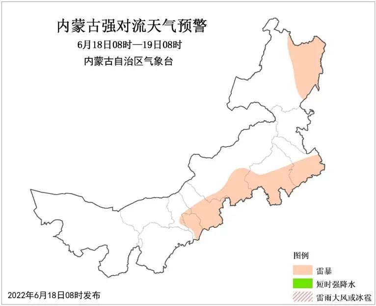
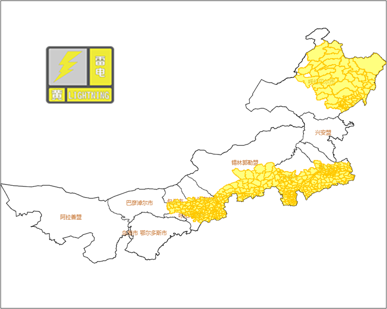
Inner Mongolia Autonomous Region Meteorological Observatory issued a strong convective blue warning at 08:00 on June 18: It is expected to be from 08:00 on June 18th to 08:00 on the 19th, most of Baotou City, most of Hohhot City, southern Ulanchabu, southern Xilinle League, Chifeng, Chifeng There are decentralized thunderstorms in the central and southern parts and southern parts, southern Tongliao, and east of Hulunbuir. Inner Mongolia Autonomous Region Meteorological Observatory, June 18, 2022, at 13:25 on the lightning yellow warning signal: Southern Baotou City in 6 hours, most of Hohhot City, southern Ulanchabu, southern Xilinle League, west and south of Chifeng City, Tongliao City, Tongliao City Thunderstorm activities may occur in the southern and east and northern parts of Hulunbuir. Local regions are accompanied by strong convection weather such as short -term heavy precipitation, thunderstorms, hail and other streaming weather, which may cause disaster accidents such as lightning, floods, and urban waterlogging. Relevant units and personnel are requested to prepare for prevention.
1
Weather overview in the next three days

From three days from tomorrow (June 19)
High temperature weather in western Inner Mongolia does not exit
The west area of Baotou City will still be the core area
The maximum temperature of the Alxa League can reach 40 ° C or more
The local public needs to pay attention to heatstroke prevention and cooling
at the same time
The rainfall will still be entangled in the eastern regions such as Hulunbuir City
There are medium to heavy rain in some areas
It is accompanied by strong convection weather such as short -term and heavy precipitation, thunderstorms, hail and other strong convection weather
Need to be alert
The heat is infinite! The large -scale high temperature in the west lasts until the 21st
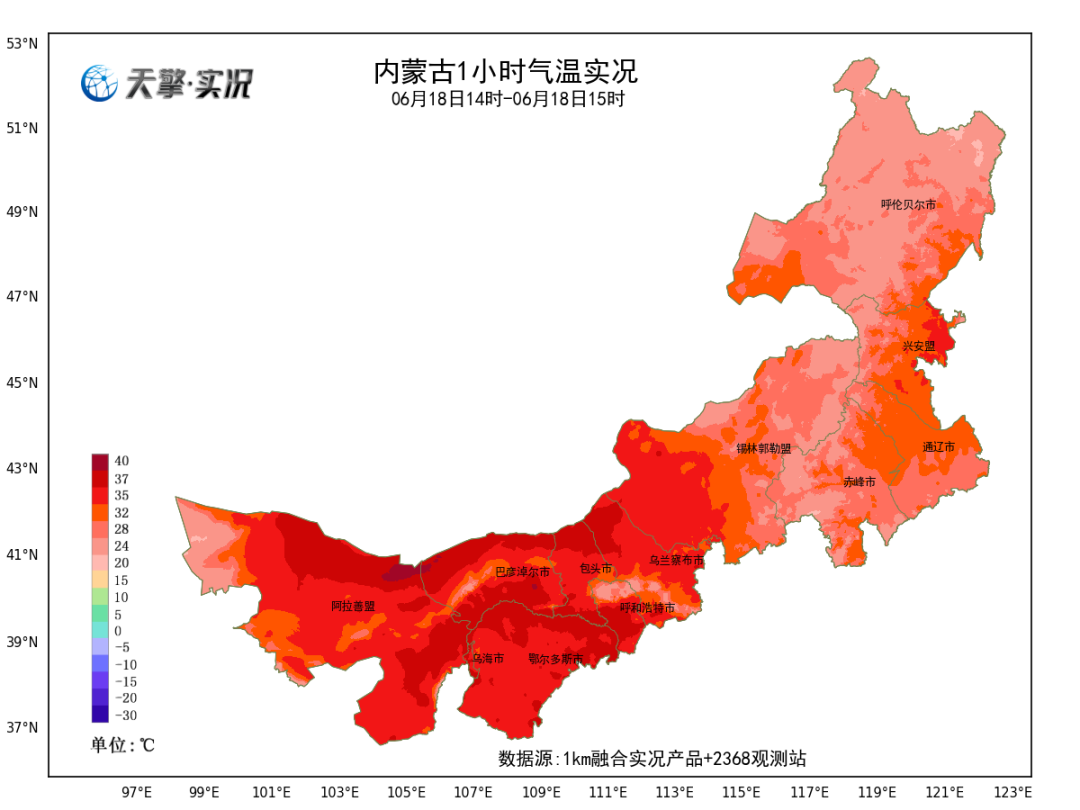
Today, the high temperature weather in western Inner Mongolia continued to develop. As of 15:00, Hohhot, Baotou, Ordos, Bayannuer City, Wuhai City, Alashan League and other places appeared large -scale high temperatures. The temperature exceeds 35 ° C. This round of high temperature weather process has a long duration and strong strength, and the maximum temperature in many places is approaching historical poles. Inner Mongolia Meteorological Observatory predicts that it is controlled by high pressure heating ridges. Prior to the 21st, the western region will continue to fight with high temperature weather. The highest temperature is above 35 ° C, and local areas can reach 40 ° C and above.
Strong rainfall and hunabel Chifeng Tongliao and other places need to be alert to secondary disasters
Tomorrow, the heavy rainfall area moves north to Hulunbuir area. Among them, there will be medium rain in the northwestern region of Hulunbuir City; the day after tomorrow, there are medium rain There are heavy rain in some areas in the eastern part of the city, and the above -mentioned areas are accompanied by strong convection weather such as short -term heavy precipitation, thunderstorms, and hail. Due to the heavy rainfall in the early Chifeng City and Tongliao City, the risk of local flood disasters has increased sharply. Relevant departments are requested to implement defense measures according to their responsibilities, and the public should pay attention to disaster prevention and avoidance.
The next three days of weather forecast for the whole district
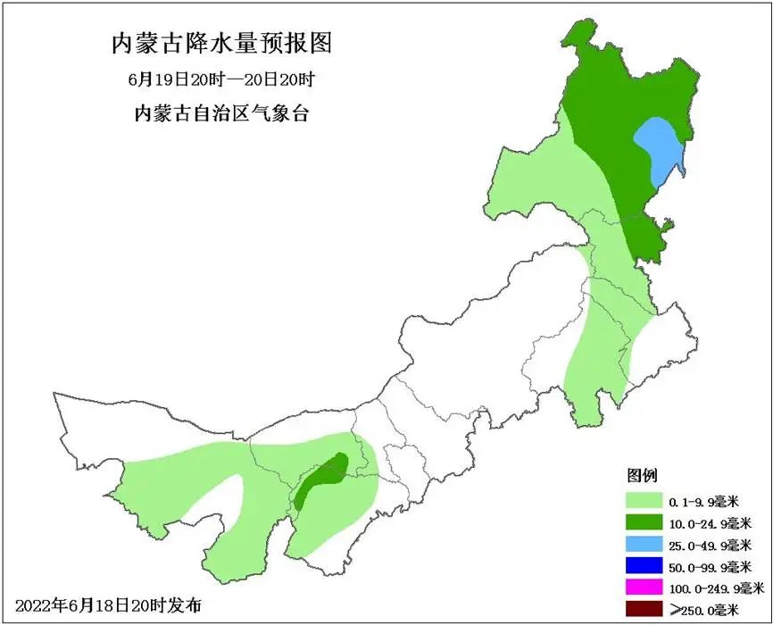
20:00 on the 18th to 20:00 on the 19th
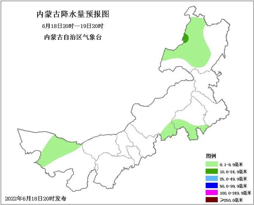
West and northeastern regions in the western and northeastern regions of our district are clear and sunny. The central Alashan League, southern Xilinle League, south of Chifeng City, and western and central Hulunbuir are decentralized light rain or thunderstorms. Among them Accompanied by short -term heavy precipitation, thunderstorms, hail and other strong convective weather, the rest of the rest is cloudy; the western part of the west and the west of the central region is 4th, 5th, 6th, 6th northwestern wind or southwest wind; There are high temperature weather at 35 degrees or more in the west of the central parts, the local area can reach 37 degrees, and the highest temperature in the western part of the west is decreased.
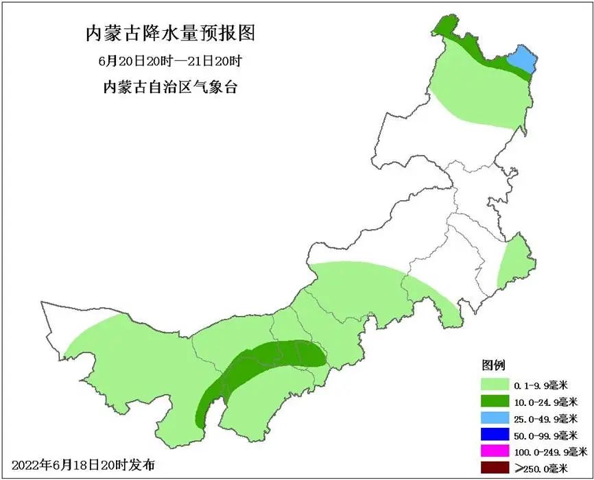
20:00 on the 19th to 20:00 on the 20th
Most areas in the region are cloudy and sunny. There are light rain or thunder shower in the city. Among them, there are medium rain in the southeast of Bayannaoer City, northwest of Ordos, northeast of Xing'an League, northern and east of Hulunbuir, and there are heavy rain in part of the eastern part of Hulunbuir City. , Thunderbolt wind, hail and other strong convective weather; the 4th, 5th, 6th and 7th west winds in the east of the central region, and the 4th and 5th short -term 6 -level 6 -level 6th -level southwind in the eastern level.
20:00 on the 20th to 20:00 on the 21st
Most of the clouds in the district, the Alashan League to the west of Xilingule League, the southwest of Chifeng City, the southeast of Tongliao City, and the northern part of Hulunbuir are light rain or thunderstorms. Among them, the eastern part of Alashan League, southern Bayannuer City, Wuhai City, Ordos, Ordos The northwest, southern Baotou, northern Hohhot, and north of the northern part of Hulunbuir City are in the area. There are heavy rain in parts of the northeast of Hulunbuir City, accompanied by strong convection weather such as short -term heavy precipitation, thunderstorms, and hail.
Source: Weather in Inner Mongolia, full contact
Coordination/Liang Jingyuan School Reading/Liang Jingyuan Preliminary Audit/Zhang Yi Feng Bin Final Audit/Zhao Min
not
not
- END -
Doumen District Meteorological Observatory issued heavy rain yellow warning [III class/heavier]
Doumen District Meteorological Observatory issued Doumen District Rain Rain Yellow Early Warning Signals at 07:05 on June 08. Please pay attention to defense.
The word "Qing" appears in the weather forecast again!From the day after tomorrow to Guangzhou

The word clear has not appeared in the weather forecast for a while, and now it is...