"Guardian Star" of deep cultivation application for food security | Report on the effectiveness of Fengyun Satellite Application ②
Author:China Meteorological Administr Time:2022.06.19

Kuragi, the world. Grain security is the "big of the country", which is a top priority related to the country and the people's livelihood. Grasp the production of food to ensure the safety of food and the acquisition and application of satellite remote sensing information.
In the past, satellite remote sensing information in the field of agricultural meteorological in my country relied on foreign remote sensing data support. The data is unreliable and the business is unreliable. It is imminent to develop its own agricultural meteorological satellite remote sensing business. Since the 18th National Congress of the Communist Party of China, independent domestic satellite remote sensing data represented by Fengyun Meteorological Satellite has gradually become the mainstream of business applications, which has changed the situation of agricultural meteorological remote sensing data relies on foreign situations. The "people star" who knows the cold and knows the heat has become the "guardian" of the "big of the country".
Plaster "Wisdom Eyes" knows the sky
As the saying goes, "watching the sky eat", meteorological conditions have an important impact on agricultural production, and satellites are a pair of "wisdom eyes" to capture meteorological conditions and agricultural production.
Satellite remote sensing monitoring around the three key aspects of agricultural weather, that is, the monitoring of crop planting distribution, crop growth monitoring, and agricultural meteorological disaster monitoring. Zhang Mingwei, an associate researcher at the National Satellite Meteorological Center, introduced that the essence of agricultural meteorological remote sensing work is a qualitative or quantitative evaluation of the impact of the past and future meteorological conditions on crop growth. Quickly and accurately grasp the distribution of crop planting, which can improve the time and space matching accuracy of crop planting distribution and meteorological element distribution, which is of great significance for improving the accuracy of improving the accuracy of agricultural meteorological disasters and the accuracy of crop output meteorological forecast. In May of this year, the China Meteorological Administration "National-Provincial-City/County" integrated large-scale large crop distribution remote sensing monitoring system was initially completed. High-spatial resolution winter wheat distributed remote sensing products were first applied to the production of food production and agriculture of the China Meteorological Bureau's summer harvesting grain crops and agriculture Meteorological disaster monitoring and early warning business adds "weapon" to ensure the harvest of food.
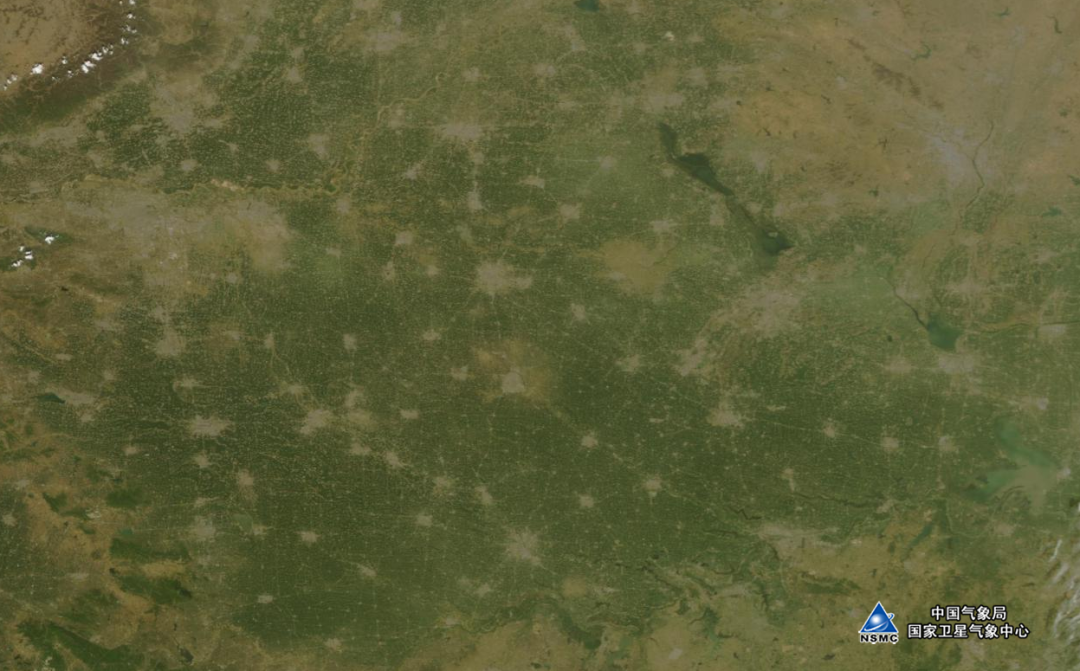
On April 10th, the greenness of the North China Plain monitoring of Fengyun No. 3 D -star is green
At the time of the "San Xia" busy season, this year's summer harvest is a tough battle. In 2021, the northern part of my country has experienced rare autumn floods. In many places, the winter wheat was postponed and the difference between seedlings was delayed. Wu Menxin, a senior engineer of the National Meteorological Center, said, "In order to win the battle for the summer grain, the meteorological department has strengthened the linkage with the agricultural and rural departments and the provinces of grain in the satellite remote sensing, and established the two -level agricultural meteorological remote sensing monitoring monitoring The linkage mechanism, using the multi -source satellite remote sensing data to comprehensively judge the growth of winter wheat, and provide the analysis report of the impact of crop growth and meteorological conditions to relevant departments in a timely manner, and provide strong technical support for relevant departments to carry out the work of winter wheat spring tube. At the end, the harvest is good, and the agricultural meteorological remote sensing service has been well received by all parties. "
From "watching the sky" to "knowing the sky", the satellite remote sensing has made agricultural production unknown to it, and it will be passive to active.
Tibetan grain on the technical side good rice bowl
To solve the problem of eating, the way out is in technology. To realize the "rice bowl mainly contains Chinese food", it is necessary to strengthen the monitoring and management of major food crops in my country.
In recent years, the Chinese Meteorological Administration, the Chinese Academy of Sciences, the Ministry of Agriculture and Rural Ministry and other departments have used Fengyun Meteorological Satellite Data as the data source to carry out the monitoring of meteorological disasters in important grain production areas at home and abroad and the monitoring and yield of major grain crops such as wheat, corn, rice, and soybeans It is estimated that it provides an important and reliable reference basis for scientific decisions.
Mao Kebiao, a researcher at the Chinese Academy of Agricultural Sciences, believes that in agricultural production, agricultural meteorological disasters have a great impact on my country's grain production, of which drought has the most impact. The surface temperature and soil moisture are important parameters in drought monitoring. In the past, related data were mainly obtained through meteorological sites, but the site was relatively sparse, the space was not representative, and the manual method was time -consuming and laborious. With the development of meteorological satellites, the number of bands and radiation resolution is continuously optimized. Its infrared remote sensing data can be reversed on the surface temperature. The microwave bright temperature data can be used to reverse soil water, which provides meteorological disaster monitoring and early warning and crop growth monitoring and output estimation estimation. Powerful support.
Remote sensing quantitative countermeasures and farmland environmental parameters, based on the data of the windy meteorological satellite data, provides key parameters of crop growth models, data assimilation systems, and crop estimation of crop growth, and provides valuable value for field agricultural management to provide valuable valuables refer to.
Fengyun Meteorological Satellite has continued to make breakthroughs in key technologies, and contributes wisdom for Chinese rice bowls and keeps Chinese food.
Looking at the future of the starry sky can be expected
Today, Fengyun No. 3 E Star, Fengyun No. 4 B Star, and its ground application systems have been transferred to business trial operation, bringing new possibilities for the development of agricultural satellite remote sensing business in the future.
Facing the future, the China Meteorological Administration will make full use of the global observation capabilities of Fengyun 3 meteorological satellites, carry out crop growth and agricultural meteorological disaster monitoring of the global main grain production area to support the global food risk monitoring and early warning business; Satellite crop planting distributed remote sensing monitoring, improve the accuracy and refinement of crop area monitoring; carry out high -spectrum remote sensing technology research and development to meet the needs of agricultural quantitative remote sensing, crop species and quality monitoring, disaster remote sensing monitoring; Key crop growth period and key agricultural management nodes for all -weather remote sensing data.
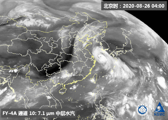
In August 2020, the typhoon "Bavai" went straight to the Northeast region, which had a varying degree of impact on local agricultural production. The picture shows Fengyun No. 4 A star water vapor monitoring animation
In the past ten years, Fengyun Meteorological Satellite has achieved comprehensive development and progress in agricultural production applications.In the next ten years, with the advancement of the construction of meteorological satellite engineering and the development of sensors, big data, artificial intelligence and other technologies, Fengyun Meteorological Satellite will continue to cultivate in the field of agricultural production around the needs of modern agricultural development.Guardian Star.Produced by China Meteorological Administration Xuanke Center (China Meteorological News Agency)
Author: Yan Hong
edit:
- END -
The latest notice of Hebei!It's about the renovation of the old community ...

Recently, the Housing and Urban -Rural Development Department of Hebei Province, t...
Harbin Nangang Passenger Transport Service Center listed on the 24th!
On the 24th, a reporter from the Dragon Head News · Life Daily learned from Harbi...