Capture the instantaneous wind and protect the beautiful home 丨 Fengyun Meteorological Satellite Application Effect Series Report ④
Author:China Meteorological Administr Time:2022.06.22

"There is a area of precipitation clouds that remain over Guangxi, Guangdong, and Fujian. There are decentralized rush clouds on the cloud belt ..." From June 6th to 12th, there are many sustainable precipitation weather in southern my country. The multi -channel cloud map provided by A star from visible light to long wave infrared, which supports disaster prevention and mitigation work in real time.

FY-4A meteorological satellite can be visible to Guangyun map (15:00, June 6, 2022)

FY-4A meteorological satellite can be visible to Guangyun map (15:00, June 12, 2022)
In recent years, the China Meteorological Administration has continuously promoted the construction of land, sea, air and sky precision meteorological monitoring system, improved the layout of Fengyun Meteorological Satellite Space, focused on short -term weather monitoring forecasts, strengthened provincial satellite remote sensing weather demonstration applications, and building the first line of defense and disaster prevention and mitigation. Essence
The typhoon path of the macro perspective is clearly visible
"Typhoon No. 6 'Fireworks' is a spiral symmetrical structure, the eye is clear, and the peripheral spiral cloud belt develops with rolling cloud feathers ..." In 2021, during the influence of Typhoon "Fireworks", Fengyun No. 4 B in the rail test stage B B The fast imaginger carried by the star carried out a continuous high -frequency observation of it for 1 minute, and joined forces with other polar or resting meteorological satellites to achieve the "Tianyan" chasing wind.
"The macro perspective of Fengyun Meteorological Satellite, high time and space surface and atmospheric mesh observation can make typhoon forecast more accurate." Wu Xiaojing, deputy director of the National Satellite Meteorological Center Remote Sensing Application Service Center, introduced. When the typhoon is located in the distant sea and lacks direct observation methods on land or islands, the meteorological satellite directly overlooks the "Typhoon Eye" from a more macro and large -scale perspective, becoming the main means of typhoon positioning and strong. Especially after the launch of Fengyun No. 4 A star, the advanced static rail radiation imaging instruments, interference atmospheric vertical detectors, lightning imaging instruments and other instruments have shortened the frequency of monitoring of catastrophic weather such as typhoons and heavy rains from 15 minutes to once every 15 minutes to Once 1-5 minutes.
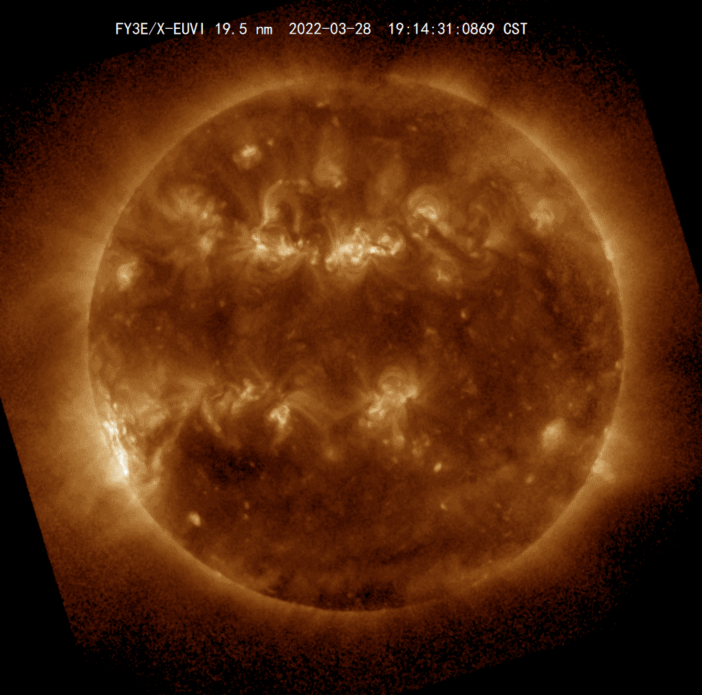
FY-3E monitor solar activity
"At present, my country's meteorological satellite loading technology indicators, posture control technology, data communication technology, product space -time resolution, etc. have made great progress, which has strongly supported the global tropical cyclone business and scientific research." Typhoon and marine meteorological forecast of the National Meteorological Center and Marine Meteorological Forecast Qian Chuanhai, director of the center, said.
Science and technology "weapon" show disaster prevention and mitigation strength
In 1977, the first generation of the polar rail meteorological satellite in my country was named "Fengyun No. 1", and the "Fengyun Era" was opened ... Later, more and more Fengyun Meteorological Satellites rose into space, and the technology "weapon" loaded with them was , Serving the people of China and the world.
In Inner Mongolia, in response to the unique terrain and landforms of the local area, the main disasters such as fire, sand and dust, the meteorological department used the resolution imaging spectrometer in Fengyun 3 D Star D -star to carry out surface water heat and vegetation parameters to produce drought monitoring service products. The Guangdong Meteorological Department used Fengyun No. 4 A star lightning imaginger to monitor 412 clouds and ground flash occurred from 19:00 to 20:00 on June 14.
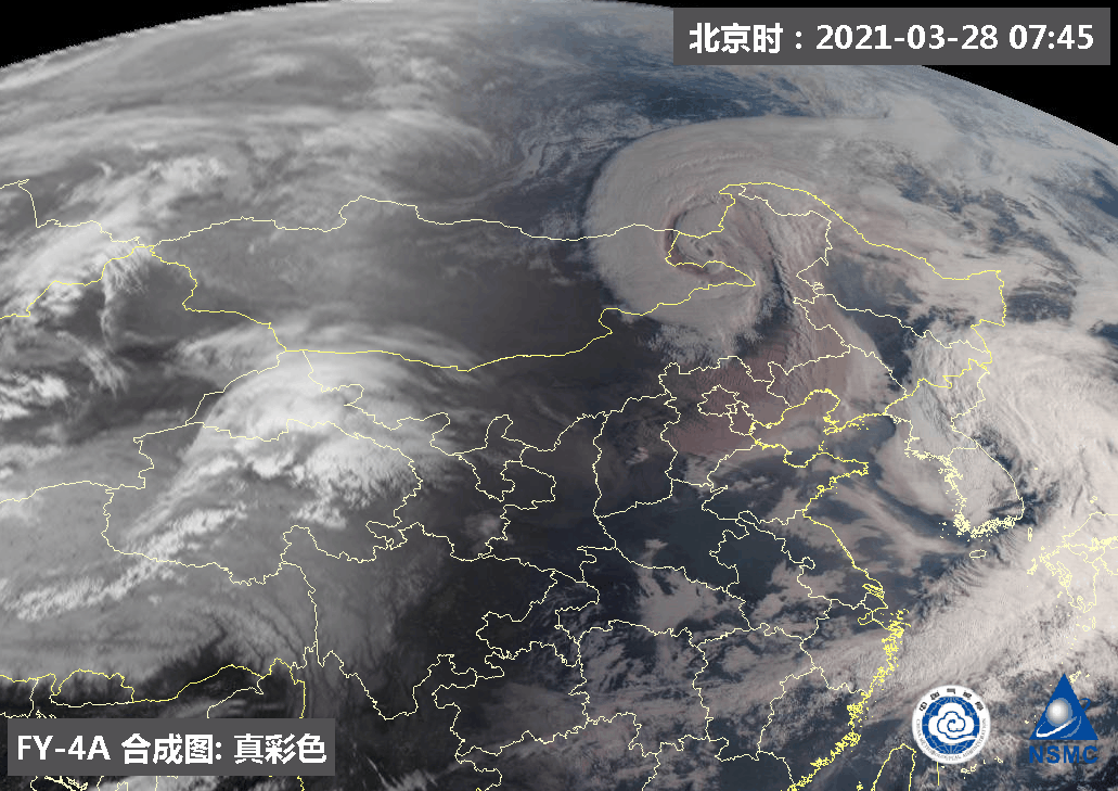
On March 28, 2021, Fengyun No. 4 meteorological satellite monitoring the movement of sand and dust in real time. Northeast Inner Mongolia can clearly see that the front cyclone cloud system has entered the stage of prison.
On June 1st, with the transfer of Fengyun 3 E Star, Fengyun No. 4, and its ground application system to the business trial operation, Fengyun Meteorological Satellite disaster prevention and mitigation strength further improved.
Among them, Fengyun No. 3 E star is the world's first meteorological satellite that integrates X -rays and extremely ultraviolet bands on the same instrument. For the first time in China, solar imaging observations in space can be monitored. The outbreak process. It can cooperate with the exploration of wide -angle aurora, global space environment, and ionization layer of Fengyun 3 meteorological satellite operating in other business, and combine the observation of Static orbit particles and magnetic fields of Fengyun 4 meteorological satellites, so that my country has achieved the first time from the sun to the earth. The spatial environment responds to the independent monitoring of the "whole process", and timely cope with the harm caused by space weather.
On the basis of A -star B, Fengyun No. 4 further improves the radiator imaginger of the static orbit, the static track interference infrared detector, and the spatial weather monitor. Mid -level continuous observation imaging.
Local optimization is profitable to avoid harm and protect the homeland
With the support of Fengyun Meteorological Satellites, all parts of the country are actively innovating in accordance with actual situations, exploring local service methods to better help meteorological disaster prevention and mitigation.
"We use the ground with the ground for 3 hours of historical observation information and the area of the Bohai Sea Ice area to analyze the relevant analysis of the Bohai Sea Ice area, select a meteorological factors with high correlation, and establish a predictive model of the Bohai Sea Ice area by returning and analysis." The Tianjin Meteorological Bureau made full use of Fengyun Meteorological Satellites to counter the area and thickness of the Winter Bohai Sea Ice, and enhance the ability to quantitatively quantitative assessment of sea ice.
According to the characteristics of South China, the Guangdong Meteorological Department combined with meteorological observation, numerical forecasting and fire insurance forecast products, developed a modular and customized platform for real -time monitoring, statistical analysis, fire risk early warning, and key areas of the forest fire information, which can meet different different Customized requirements for industry users. During the Qingming Festival this year, the meteorological department provided satellite fire monitoring services in real time, and a total of 110 fire points were monitored.
The Shenyang Institute of Atmospheric Environment has developed the relevant technologies of Fengyun No. 4 A -Star A -Star Advanced Radio Radiation Imaginger, interference atmospheric vertical detector radiation data assimilation data based on the medium -scale numerical mode, and complete the direct assimilation of the above -mentioned radiation data in the regional mode.Application research.In Jiangsu, the meteorological department uses Fengyun Meteorological Satellite to conduct technical innovation in the anti -discrimination of atmospheric parameters, carry out multi -parameter -dimensional -dimensional variable -dimensional counter -discrimination research, and obtain practical data such as cloud water structure, precipitation intensity, and surface parameters.
Produced by China Meteorological Administration Xuanke Center (China Meteorological News Agency)
Author: Li Yue and Wang Liang (Zhang Yan, Wang Tianwei, Shi Yanjun, Zhang Yuqi, Chen Liqiang, Wang Yanhan, Sun Xiaolong, Hang Xin contributed to this article)
Picture: National Satellite Meteorological Center
edit:
- END -
Guoyuan County Meteorological Observatory update lightning yellow warning [Class III/heavier]
Guyuan County Meteorological Observatory continued to release thunder and yellow warning signals on June 08, 2022: According to the latest analysis of the latest meteorological data, all towns and vil
The Chinese Red Cross won the highest award for the International Federation of the Red Cross and the Red Crescent Society
Xinhua News Agency, Geneva, June 20 (Reporter Liu Qu) The Red Cross and the Red Crescent International Federation will be awarded to the Henry Davison Award on behalf of the Federation of the Federati