Wang Liheng et al. -Gca: Reacting solubility migration simulation reveals that the water erosion of the bottom of Huangshi Lake has evolved time and space
Author:Institute of Geological Earth Time:2022.06.25


Yellowstone National Park is the first national park in the United States, known for its extremely rich wildlife types and geothermal resources. The entire park is located on the largest and most active super volcanoes in North America -Huangshi volcano, so there are tens of thousands of surface thermal display (intermittent spring, hot springs, water heat explosion points), strange geological phenomena and diverse geography Landform characteristics are not only favored by tourists all over the world, but also attracted the attention of a lot of scholars.
Yellowstone Lake, located in the middle of the middle of Huangshi National Park (Figure 1B), is the largest freshwater lake in this area. The bottom of the lake is also distributed with a large amount of hot liquid jets and jet holes. It is found that through a series of on -site monitoring of remote control robots entering the bottom of the lake, it is found that the deepest "Deep Hole Region" (about 125m, Figure 1c) at the deepest "deep pit area" at the bottom of the lake is a typical high temperature (174 ° C), acidic (acidic) PH = 4.2) The environment is also observed that a large amount of bubbles overflow from the hot liquid spray mouth at the bottom of the lake. After testing and analysis, the main components of these bubbles are CO2 and H2S. Obviously, the process of high -pyreces -rich vapor -rich in magma gas (CO2 and H2S) passes through the bottom of the lake and eventually overflows from the deep part, which will definitely have a significant transformation effect on the rock at the bottom of the lake, and then control the formation and evolution of the deep pit area of the lake.
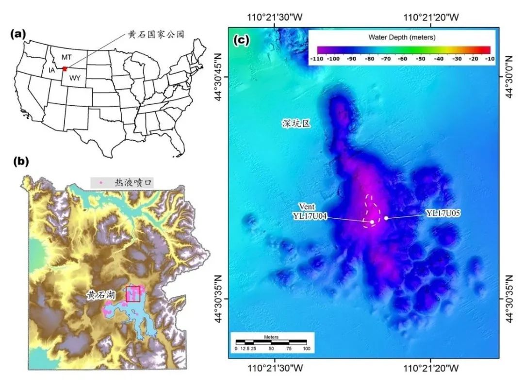
Figure 1 (A) Huangshi National Park is located in the United States; (b) the location of Huangshi Lake and Deep Hole Region in Huangshi Park; Point (representing erosion minerals), YL17U05 represents a sampling point from the position of the spray port (representing fresh minerals)
In recent years, many scholars have carried out a large number of research work on the characteristics of earth chemical evolution and geothermal systems on the deep pit area of Huangshi Lake. Long -term monitoring found that at the bottom of the lake away from the hot liquid spray mouth, it is distributed with abundant non -crystal silicon, potassium long stone and a small amount of red iron ore, magnetite and other minerals (YL17U05); Minerals and other minerals (YL17U04). Therefore, it is speculated that the minerals away from the spray area of the hot liquid represent the fresh mineral, and it gradually evolved into the etching mineral near the thermal jet port under the action of high -pyreces vapor mixed with magma gases. Is this speculation reasonable? How does the rock water heat erosion process control the terrain evolution of the deep pit area?
In response to the above problems, the Institute of Geology and Geophysics of the Chinese Academy of Sciences of the Institute of Geology and Geophonous Institute of Geoscopy and Geological Engineering Institute of Geosciences Wang Liheng, Associate Researcher Dong Yanhui, United University of Mindy, William E. Seyfried Jr. The Reactive Transport Modeling (RTM) method, a two -dimensional numerical model of typical section has been established for the deep pit area. This model will coupling multi -phase flow, thermal transport, chemical reactions and terrain changes, simulation the characteristics of minerals with the changes in minerals at the bottom of the lake at the bottom of the lake at the bottom of the lake, and predict and analyze the process of time and space evolution of the terrain and space in the deep pit area. the result shows:
(1) Highly steam with magma gases overflows along the hot fluid at the bottom of the lake to control the pressure, temperature and acidic environment of the floor of the lake; the high temperature and acidic environment prompts the non -crystal silicon to quickly dissolve (within about 10 days) and and the same as within about 10 days) and and the same as within 10 days) and and the same as within 10 days) Converted into a relatively stable quartz, which caused the concentration of silicon dioxide to overflows the fluid of the spray mouth to rises quickly and keeps stable; the process of transforming potassium long stones into kaolin and mallow stones is at a scale to a thousand years (0.5 ~ 1.5ka); In addition, the red iron ore exposed in the H2S gas environment has also begun to be formed around 0.55 years, and eventually spreads all over the simulation area (Figure 2). This simulation result is consistent with the on -site observation;
(2) The volume loss of mineral water thermal erosion process is one of the important reasons for the depression of the deep pit area. It is found that after the simulation calculation, after 1 k. A. After the water etching changes, the terrain of the simulation area will be depressed downward. 20M, after 10k.a., a inverted conical depression area with a diameter of more than 5m and a depth of more than 32 m (Figure 3) will be formed (Figure 3).
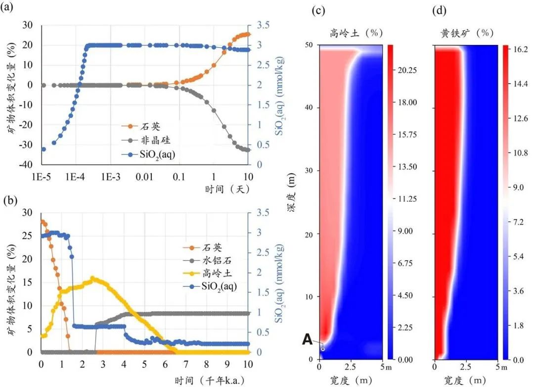
Figure 2 (A, B) The mineral erosion process at the bottom of the simulation area, the left vertical coordinates are the volume of the mineral volume, the negative value represents the decrease in volume, the positive value represents the increase in volume, the right vertical coordinates are the concentration of the liquid silicon dioxide; C. D) At the end of the simulation period, the volume of the volume of Kaolin and Pymaline ore in the simulation area is distributed. The model width is 5 m and the depth is 50 m
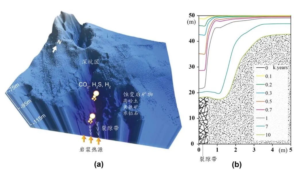
Figure 3 (A) Mineral erosion process and three -dimensional terrain distribution of the deep pit areas at the bottom of the lake;
RTM is an important tool for explaining the coupling process in the earth system and the influence of different space -time standards on it, especially in quantitative processing of complex global chemistry process. During the heat discharge of the bottom thermal fluid of Huangshi Lake, a typical water-rock-gas reaction system was formed after the magma gas was mixed. On the one hand, the corrosive high -temperature thermal fluid accelerates the process of mineral erosion of the lake at the bottom of the lake; on the other hand, mineral erosion changes significantly change the penetration performance of the bottom of the lake, determining the flow speed and discharge flux of the high temperature thermal fluid. Between influence and restricting each other. This study uses RTM to quantitatively describes the process of water etching in this complex steam geothermal system and deduced the process of time and space evolution of the bottom terrain of Huangshi Lake. This not only provides a scientific basis for deep understanding It also provides a new idea to understand the material circulation and geomyochemical evolution in similar systems (such as the hot fluid system of the ocean, such as the ocean spine system).研究成果发表于国际学术期刊Geochimica et Cosmochimica Acta(王礼恒,董艳辉,Amanda Tudor,谭春阳,William E. Seyfried Jr. Geochemical evolution of a sublacustrine hydrothermal vent systems: Temporal constraints imposed by reactive transport modeling [J]. Geochimica et Cosmochimica Acta, 2022. Doi: DOI: 10.1016/J.GCA.2022.06.003). Studies were funded by the National Natural Science Foundation (41702273), the National Natural Science Foundation (EAR-1515377), and the National Study abroad Fund Commission (201904910227).
Beauty editor: Fu Shixu
School pair: Wanpeng
- END -
Photo Aba | Huanglong, orchid drunk tourists ~

Smartworm / PictureYellow dragonOrchid drunk touristsOrchid drunk tourists1Huanglo...
"Living here, happiness is explosive" -When Lujiang urban and rural areas in Anhui
[Enter the county seat to see development]Guangming Daily reporter ChangheCha Haixia finally failed to resist the temptation from the circle of friends. On the evening of June 14, she and her two fema