High temperature loss!This round of heavy rainfall was earlier than previous years | Expert interpretation
Author:China Meteorological Administr Time:2022.06.26

On June 25, there were more decentralized precipitation in Gansu, Sichuan, Liaoning, and Fujian in my country. The forecast shows that from the 26th to the 28th, the development of precipitation is enhanced. There will be a round of heavy precipitation in the Sichuan Basin to North China and Huanghuai. During the rainfall, it will also be accompanied by strong convection weather. The Central Meteorological Observatory continued to issue heavy rain and strong yellow warning. Affected by rainfall, high temperatures in North China, Huanghuai and other places were relieved.
Expert: Yu Chao, senior engineer of the Central Meteorological Station
Interviewer: China Meteorological News reporter Li Yue
1. Strong precipitation with strong convection weather
From the day of June 25th to the night of 26, precipitation has been strengthened in southern Gansu and Sichuan Basin, and the time process is in line with the forecast. At the same time, there are also heavy rains in the southern and eastern parts of Sichuan Basin, which is consistent with the early forecast.
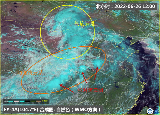
June 26, 2022 at 12:00 FY-4A Meteorological Satellite Natural Color Synthetic Map Source: National Satellite Meteorological Center
From the 26th to 28th, the south of Shaanxi, the northeast of the Sichuan Basin and the southwest, the west and northern parts of Chongqing, the central and eastern parts of North China, Huanghuai, Jianghan, Northeast China and the north, northwestern parts of the country, and northwestern China There are heavy rains in some areas, heavy rain in the area, cumulative precipitation is generally 50-70 mm, 100 to 180 mm in some areas, and local area may exceed 200 mm. The above -mentioned areas will be accompanied by strong convection weather such as short -term precipitation and thunderstorms.
On the 26th, precipitation was concentrated in southeast Shaanxi, east and southwest of Sichuan Basin, western Chongqing and north and northwestern Hubei, central Henan, eastern Shandong, northern Tianjin, northeast Beijing, and central Liaoning. There are heavy rains in eastern Henan and Shandong. The precipitation is generally 50-70 mm, and the local area is 100 to 180 mm.
On the 27th, there were heavy rains or heavy rain in the central Liaoning, the central and eastern part of Jilin, the southern Shandong, and northern Jiangsu and Anhui.
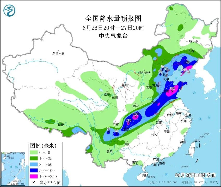
National precipitation forecast map (20:00 on June 26 to 20:00 on 27)
During the precipitation period, it will also be accompanied by strong convection weather:
On the 26th to the night of the 27th, the central and southern Hebei, southern Beijing, south of Tianjin, south of Tianjin, Shandong, northeast of Henan and west, northern Anhui, northern Jiangsu, northern Hubei, southeast of Sichuan, western Chongqing and other areas will be 8 To level 10 thunderstorms or hail weather, the local wind can reach level 12.
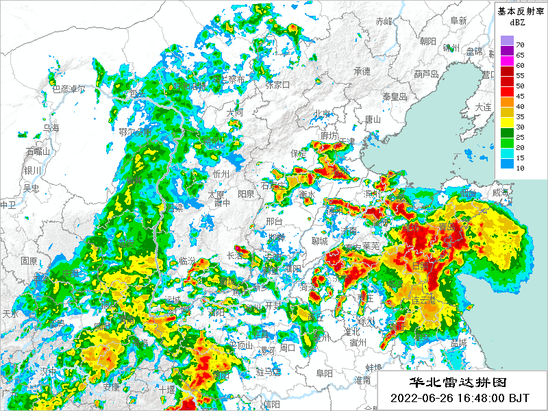
North China, June 26, 2022, 16:48 to 17:30 on the radar
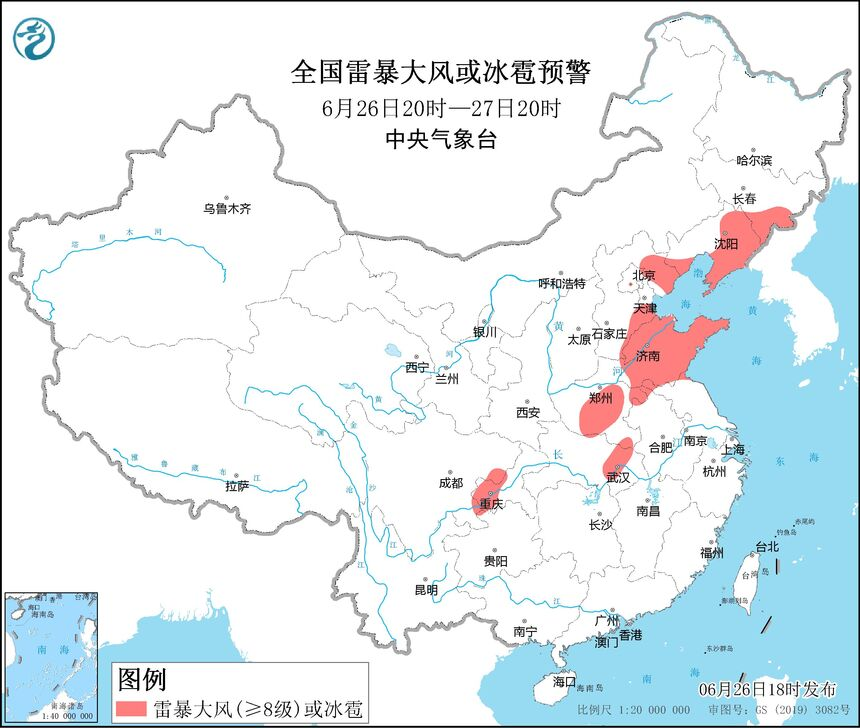
National thunderstorm or hail warning (20:00 on June 26th to 20:00 on 27th)
East Inner Mongolia, eastern Liaoning, southern Shaanxi, central Hebei, eastern and southern Beijing, Tianjin, Shandong, Henan, northern Jiangsu, northern Jiangsu, eastern and southern Sichuan, western Chongqing, northern and eastern Fujian, southeast Guangdong, Guangdong There will be short -term heavy precipitation weather in some areas of the central part of Taiwan. The rainfall is 30 to 70 mm, and the local area can reach more than 90 mm.

National short -term heavy precipitation warning (20:00 on June 26th to 20:00 on 27th)
2. Northern precipitation time is earlier than before
Due to the relatively stable position of the Western Pacific subtly high -pressure position, the western high -altitude slot has been strengthened from the eastward movement from the northwest. There are low vortex systems and southwest rapids in the lower levels. The ground has a cyclone on the ground. The joint effects of multiple weather systems have caused this precipitation process. There are three characteristics of this weather process: large rainfall range, development of mobility, and cumulative precipitation in some areas may exceed the extreme value of the same period.
FY-4B fast sweep animation source:
National Satellite Meteorological Center
As the subtropical high pressure gradually retreats to the sea, the South China Sea and Southwest season wind carrying sufficient warm and humid water vapor extends all the way to the northern region. In addition, the northern region is at the bottom of the cold vortex in the northeast. Regional heavy precipitation process. For the northern region, this precipitation is the strongest process since the flood this year.
In this season, the process of such a intensity in the north is normal, but it is not normal in time. Generally, the main rainfall period in the north is from mid -late July to early August. This time, the appearance of heavy precipitation is earlier than the "traditional" northern rainstorm.
3. Precision is conducive to agricultural water storage and water storage
The rainfall process is very beneficial to crop growth and agricultural water storage water storage. Hebei, Henan, Anhui, Shanxi, Shaanxi, Gansu and other places will be further improved, and drought in most areas is expected to alleviate.
Precipitation will also effectively alleviate high temperature weather in the early stage. In the next week, there will be no large -scale high temperature weather in the central and eastern regions of my country. However, there will be intermittent high temperature weather in some areas of Huanghuai and Jiangnan.
Expert tips
This round of precipitation from the Sichuan Basin to North China and Huanghuai has a wide range of precipitation process, fast rain belt movement speed, mainly on diversion precipitation.
Cities with centralized precipitation should take heavy rain disaster response measures in advance to prevent the adverse effects of heavy precipitation on urban transportation, drainage, power communication, urban operation protection, and epidemic prevention and control;
The public needs to pay attention to carrying rain gear, pay attention to the nearby forecast, early warning information and traffic information, and try to avoid going out during the strong period of active flow;
Shandong, Henan and other places need to pay attention to preventing the drought and floods caused by heavy precipitation in the local area, and the low -lying fields will be drained in time after the rain.
10 days in the next 10 days
Except for this strong precipitation process
There is no large -scale rainfall process across the country
Huanghuai, Huanghuai, Jianghuai, Jiangnan and other places
There will be intermittent high temperature
Produced by China Meteorological Administration Xuanke Center (China Meteorological News Agency)
Author: Li Yue
Video: Zhang Yubo
Edit: Muyou Liu Shuqiao
Review: Ji Jiamei

- END -
Jiuquan's epidemic prevention and control latest reminder (16:00 on June 21, 2022)
1. New case situationJune 20, 2022 (0-24 o'clock)1. 9 cases of new local confirmed cases6 cases in Shanghai;3 cases in Beijing, including 2 cases of Changping District and 1 case of Fengtai District.2...
Weifang created "East Asian Cultural Capital" | Qingzhou Cultural and Tourism Bureau strengthened three measures to enhance the influence of cultural tourism brands

In recent years, the Qingzhou Cultural and Tourism Bureau has established a full m...