just!Zhejiang has broken through the high temperature line in many places!Mo Yu, high -temperature collective retreat from the day, but it must be guarded in the afternoon
Author:Voice of Zhejiang Time:2022.06.29
Source: Zhejiang Weather
The copyright belongs to the original author, if there is any infringement, please contact it in time
The poet said: "Mei Yuyu, the summer wind, the high willow, and the cicada." It is very popular. Since the plums in our province on the 26th, the summer heat is fumigation and the high temperature is dense. It looks like a midsummer.

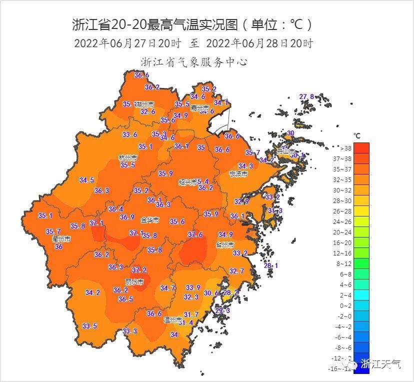
Yesterday, our province was still a high -temperature day. The highest temperature was 35-37 ° C along most of the coastal areas. Although the heat is hot, the subtropical high pressure is gradually retreating. The degree of heat decreased slightly.
Looking at this trend, yes, the weather pattern has been adjusted. Next, the "Yu Jun" began to be active, and the "High temperature king" was a little slack.
Today's weather elements are much more rich. Sunlight, high temperature, showers, strong counterparts, etc. will find a place in our province. In the early morning of this morning, there was a short -term rainstorm in northwestern Zhejiang.

Pay attention! Today, there will be obvious shower or thunderstorms in northwestern Zhejiang. Other regions are mainly decentralized thunderstorms in the afternoon. We will beware of the short -term rainstorm and 7 to 9 thunderstorms.
Today's starting temperature is still relatively "high-profile". Most of our provinces are between 26-29 ° C, and it has not had time to be sprinkled down by showers. It is hot enough in the morning! At 11:00, Hangzhou, Jinhua, Songyang and other places have taken the lead in breaking the high temperature line! In short, today's heatstroke and sunscreen lightning and lightning and lightning and lightning and lightning and lightning and lightning and lightning and lightning!
In early July, in addition to the main coastal areas, most of the provinces maintained the weather formula of "cloudy clouds+thunderstorms in the afternoon" in our province.
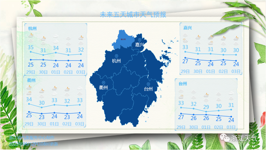
Fortunately, due to the influence of the east airflow, plus this shower is like a "antipyretic medicine". From tomorrow, the high temperature of our province has been exited with high temperatures, but due to the large humidity, the sweltering feeling of summer is still lingering, or it is still still lingering, or it is still still lingering, or it is still still lingering, or it is still still lingering. Pay attention to physical and mental regulation.
Finally, let's explore the news of Typhoon together!
Typhoon, maybe more than one?
At present, there is a low pressure disturbance on the South China Sea. The end of June-early July may be strengthened into a typhoon on the South China Sea. The fastest day and the last day are landing in South China. The high probability is Guangdong, and it is not ruled out to go to Hainan.

In the Northwest Pacific-East China Sea, a typhoon event was also predicted in early July. Keep your attention! (Content source: Weepage weather forecast)
- END -
Hot ҈ Hot ҈ Hot 周 ... This week, high temperature will be full of diligently!

Affected by high -pressure spinal controlThis week's high temperature weather will...
Flood prevention and typhoon drills, "safety nets" of the weaving masses!
Peninsula all -media reporter Xie Haojun correspondent Jiang YingjunIn summer, Lai...