Is the first typhoon that landed in our country this year?There may be heavy rainstorm in South China.
Author:Changjiang Daily Time:2022.06.30
Eye is about to be over in June
Go to the end of the moon
Guangdong has ended this strongest dragon boat water in the past 10 years
The strongest rainfall process in the north has also ended

According to the National Climate Center, Jiangnan and the middle and lower reaches of the Yangtze River have entered Mei on May 29, but as of now, the rain in Meiyu District is still significantly less than the same period, especially in Zhejiang.
The high temperature continues from the beginning of the month to the end of the month
The northern obvious heat is higher than the south that rains the previous rain

The high temperature in the north will be "burned" until July
But the high temperature center is from the previous Central Plains area
Shit west to Northwest China
It is expected to be in the future
The rainfall in the northwest and the increase in high temperature development
In many places, there will be rare continuous high temperature
Like Xi'an and Lanzhou continuous high temperature days
It can reach at least 4 or 5 days
And the high temperature intensity can reach about 40 ℃
Overall
High temperature in the central and eastern regions will gradually decrease
However, due to the increase in relative humidity
The temperature of many places will still be above 35 ° C
Like Changsha, Nanchang
The highest temperature in the next week is about 33 ° C
The lowest temperature is also above 25 ° C or more
It feels sultry


A little hotter
The body sensing temperature is also possible to 40 ° C
For example, yesterday's Guangzhou
At 14:00, the temperature is 35.3 ℃, and the relative humidity is 58%
The convertible body temperature is also above 40 ° C
Don't worry
This kind of sultry weather will not last too long
After all, the typhoon of "booking" is coming

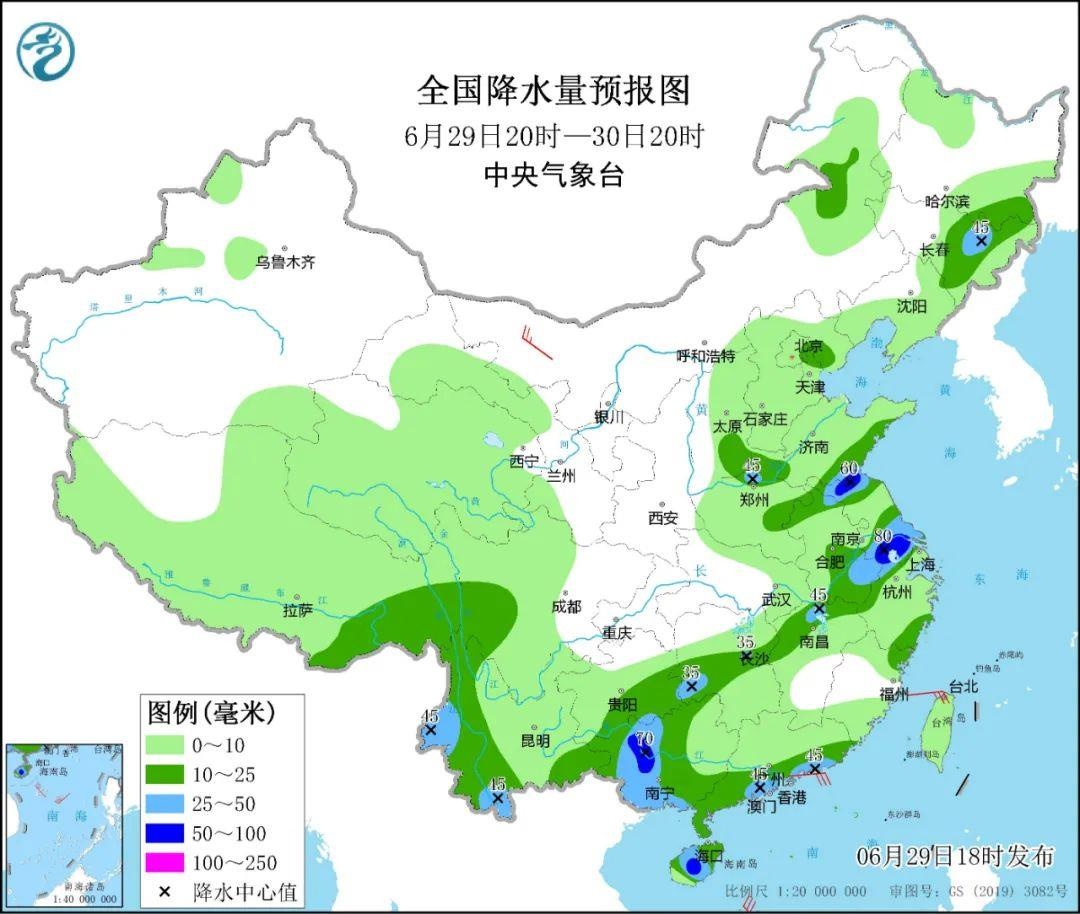
The tropical low pressure on the sea surface of the central part of the South China Sea has been generated on the morning of the 29th
Central Meteorological Observatory estimates
This low voltage is likely to develop into Typhoon No. 3 this year from the next 12 to 36 hours
And will be from July 2nd to 3rd
Laying along the coast of the eastern part of Hainan to west of Hainan
It may become the first typhoon to land in my country this year
Affected by it
Start on July 1st
There will be greater wind and rain in South China and its southern waters

Specifically
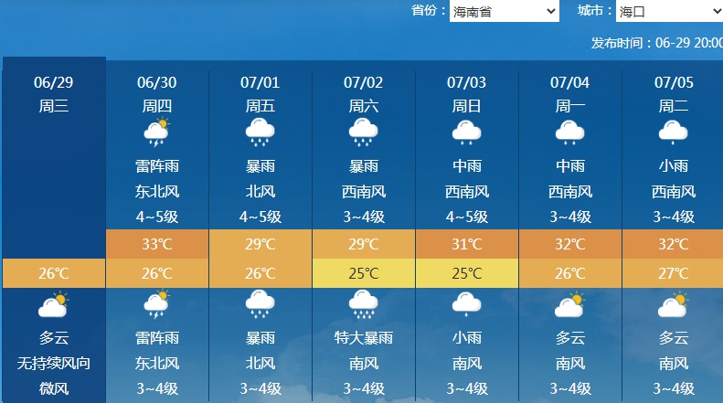
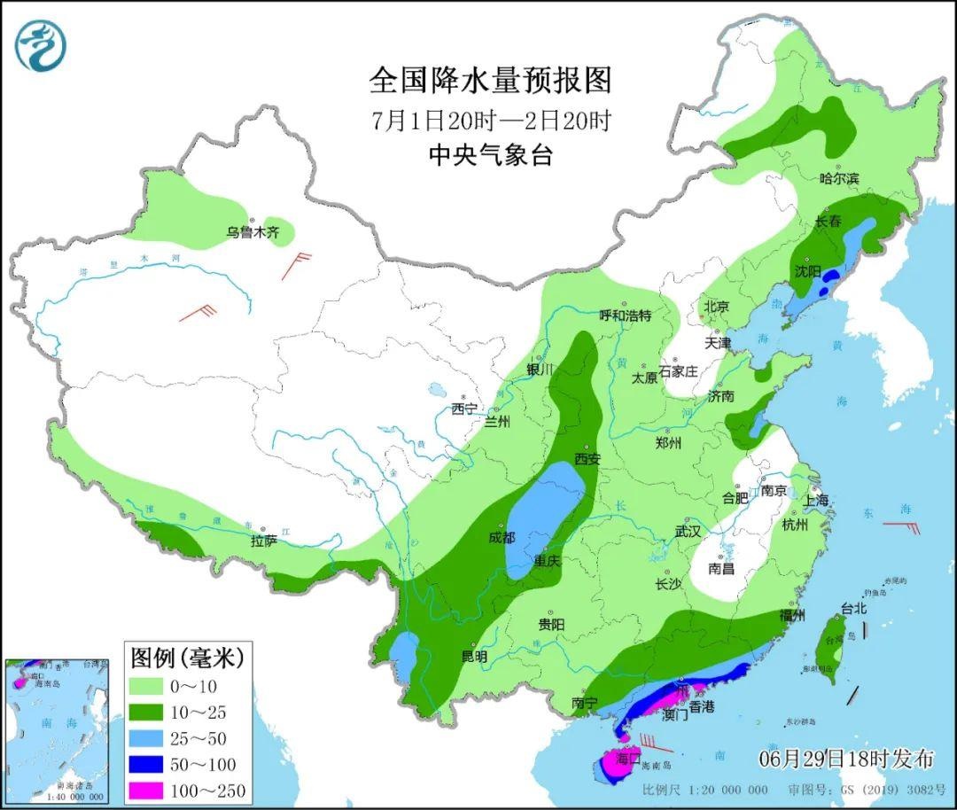
Today, on July 2, Hainan will continue to strengthen rainfall
Haikou started to increase rapidly today
It will also encounter heavy rain or even heavy rainstorm
From July 1st, the rainy coast will also be enhanced
Subsequently, the south of Guangxi will also suffer to heavy rain or even heavy rain.

The typhoon season has opened this year
Everyone pays attention to local early warning forecast
Defending strong wind and heavy rainfall in advance
(Source: China Weather Network)
【Edit: Shang Pei】
For more exciting content, please download the "Da Wuhan" client in the major application markets.
- END -
Live trailer 丨 The Light of Wisdom \u0026 LT; Tao Te Ching\u003e Talking on the Book of Books \&q

Co -planned by the Propaganda Department of the Zhoukou Municipal Party Committee...
People's Daily Overseas Edition Like Jilin: Four Visits Chagan Lake

People's Daily Overseas Edition (07th, July 02, 2022)When I first arrived in Jilin...