"Chu Chu" is late?Experts: In the first half of the year, there were few typhoons, but non -rare | Data News
Author:China Meteorological Administr Time:2022.07.01

On June 30, the tropical low pressure in the South China Sea was strengthened to Typhoon Siaba (Tropical Storm) (English name: CHABA; Source: Thailand; Name: Tropical Flower).
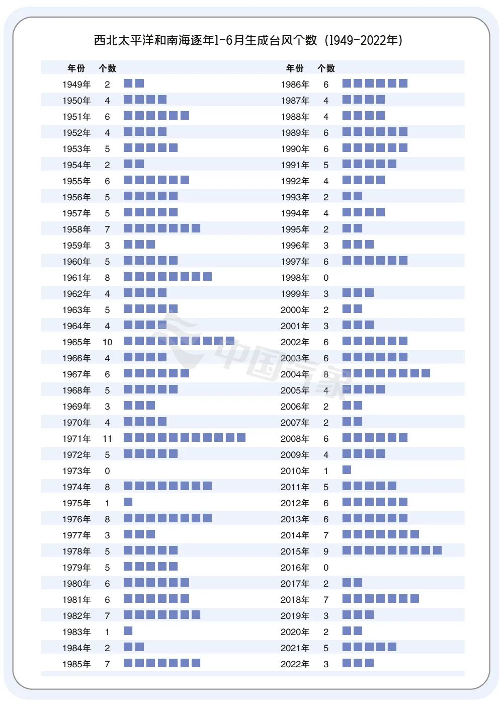
As of June 30, the Northwest Pacific and the South China Sea were generated in the first half of this year. According to statistics from Typhoon and Marine Meteorological Forecast Center of the National Meteorological Center, 4.6 typhoons were generated in history (1949 to 2021). In the first half of this year, the number of typhoons had a small number of typhoons.
01
Will La Nina continue to lead to less typhoons?
According to Wang Yan, a senior engineer of the Typhoon and Marine Meteorological Forecast Center of the National Meteorological Center, since 1949, the number of typhoons in the first half of the year has not exceeded 3 % of the year. The phenomenon of "empty platform" in June. From this perspective, the situation of less typhoons in the first half of this year is not extreme.
The main reason for the fewer typhoons in the first half of this year is related to the Lamina incident that is still continuing.
Han Rongqing, a typhoon prediction of typhoons and researchers at the National Climate Center, pointed out that this La Nina incident began last fall and has reached its heyday in winter. This spring not only has no decay, but has strengthened stage development. This situation is very rare in history. The sustainable development of the La Nina incident will inspire a pair of abnormal anti -virus rings based on the low -level tropical atmosphere on the west side of the cold water. Among them The waters on the east side of the Philippines. This large -scale circulation is extremely disadvantaged, which has caused the typhoon generation in the first half of this year.
Han Rongqing believes that the annual changes in the number of typhoons in the first half of the year have a very close relationship with the development and evolution of the Tropical Middle East Pacific Sea. When the surface temperature of the East Middle East Pacific Sea rises from January to June (in the past 5 years, such as 2018 and 2021), it is easy to lead to the development of large -scale atmospheric circulation and turbulence in the Northern Pacific and South China Sea Typhoon. ; Conversely, when the temperature of the sea surface turns cold (in the past 5 years, such as 2020 and 2022), it is easy to cause the large -scale atmospheric circulation of typhoons to develop an anti -virus development, which is not conducive to typhoon generation.
02
Will the typhoon be tied in the second half of the year?
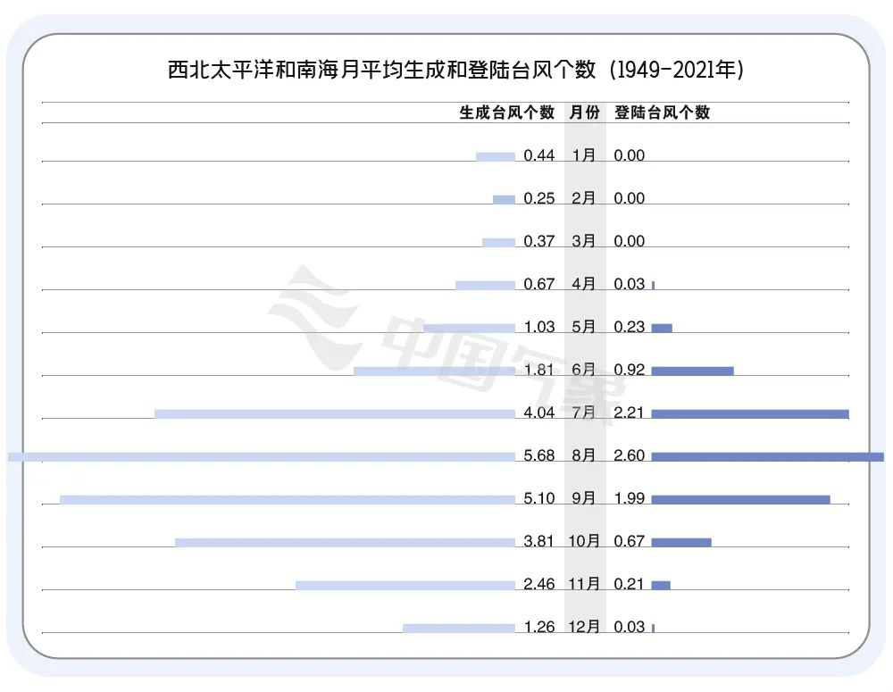
In the first half of the year, the typhoons were rare. Will the typhoon in the second half of the year come? According to the best path of typhoons reorganized by the China Meteorological Administration, from 1949 to 2021, the number of typhoons was basically not related in the first half of the typhoon. From the perspective of statistical results, there are 14.8 typhoons generated in July to September, which is the active season of typhoons, and it is also a period when typhoon is active.
The National Climate Center expects that the number of typhoons has a small number of typhoons and weak overall strength this year, but the landing typhoon may affect the situation of the northern region (referring to 30 ° north latitude). It is estimated that from July to December, the number of tropical cyclones in the Northwest Pacific and South China Sea is 15 to 18, which is less than that of the year (21). To less.
03
When will the first platform come?
In the early Taiwan, it generally refers to the first typhoon that landed in my country.
Chu Taiwan is mainly concentrated in June and July. In the past 30 years (1991 -2020), the average landing time in the early Taiwan was June 28. The first month of the first Taiwan was June (14), followed by July (12). In 2008, the typhoon "Raccoon" landed on April 18 in Longlou Town, Wenchang City, Hainan Province. Typhoon "Pabu" in 2007 landed on August 8th, Taiwan Hengchun, the latest landing in the past 30 years.
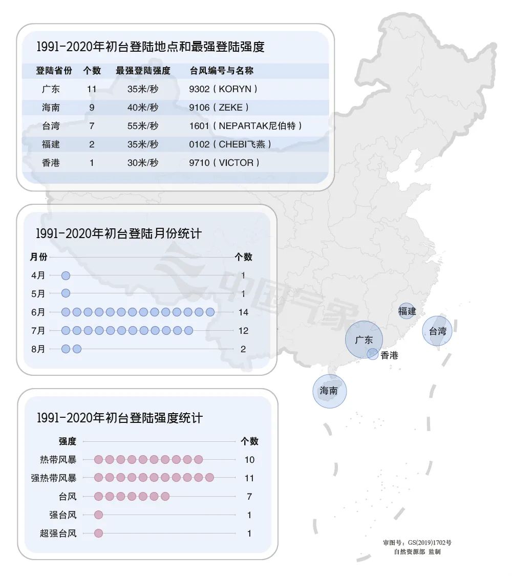
The average landing intensity of the early Taiwan is 28.8 meters/s (strong tropical storm level), and the average peak strength is 33.6 meters/s (typhoon level).
From 1991 to 2020, the land landing land covered Guangdong, Hainan, Taiwan, Fujian, and Hong Kong. Chutai generally landed in low -latitude coastal areas such as South China. The most common landing land is Guangdong, Hainan, and Taiwan. Among them, the year of landing in Guangdong is the most, 11.
04
Why do Europe and South America less encounter tropical cyclones?
Tropical cyclones have different names in different seas of the world. Tropical cyclone active in the Northwest Pacific is called typhoon. It is called a hurricane in the Northeast Pacific and North Atlantic Ocean. It is called a cyclone storm in the North Indian Ocean. Asia, North America, and even Africa often suffer from tropical cyclones, but Europe and South America rarely be affected by tropical cyclones.
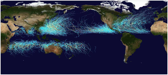
From 2001 to 2020 Global Meteorological Observatory of Global Tropical Circus Route Map
According to Wang Yan's analysis, tropical cyclone is a catastrophic weather system that affects global tropical and subtropical waters and regions. Tropical cyclone generation and development require warm and deep seawater layer, high mid -to -low layer humidity, counter -stability layer knot, certain certainty, certainly necessary Factors such as ground turn bias and lower vertical wind cutting. Due to the low temperature of the southeast Pacific and the southern Atlantic ocean, the warm water layer is light, and the environmental vertical wind is large, and the condition of the lack of tropical cyclone generation and maintenance is very rarely generated. In addition, although there is a deep warm water layer near the equator, due to the extremely small force of the ground rotation, there is generally no tropical cyclone production near the waters near the equator within 5 ° north -south latitude.
Most of Europe is located in the middle and high latitudes north of 40 ° north latitude. Tropical cyclone is no longer the "protagonist" of the weather stage. However, some North Atlantic hurricanes interact with the mid -latitude system in the process of moving to the middle and high latitude, moving to the northeast and gradually transforming into temperate cyclones, which will also bring strong winds and precipitation to Western Europe. South America is rare in tropical cyclone because of the development of the surrounding ocean that is not conducive to the development of tropical cyclones. The average global average of about 80 tropical cyclones is generated, of which the northwest Pacific is the largest, about one -third of the number of global generation. The Northeast Pacific, near Australia and the Southwest Pacific are generated about 15 each year; other sea areas, such as the North Atlantic Ocean, the northern and southern Indian Ocean generates about 10 each year. Logining to the tropical cyclone is mostly affecting the coastal areas of East Asia, Southeast Asia, South Asia, and North America. my country is one of the few countries in the world with the most serious affected by the tropical cyclone.
As of June 30, there were 29 tropical cyclones in the world this year, of which 8 were generated in the northern hemisphere, which was 2.1 less than the same period of the same year; 21 southern hemisphere was generated, 1.6 more than the same period of the same year; from late January to late February, Rare 4 tropical cyclones ("Anna", "Baziere", "Dumko" and "Emnati") have successively landed in Madagascar, and they also hit many countries such as Madagascar, Mozambique, and Malawi. In April, the northwest Pacific tropical storm The "catfish" created the Philippines; in May, the Northeast Pacific Hurricane "Agatha" seriously affected Mexico.
Produced by China Meteorological Administration Xuanke Center (China Meteorological News Agency)
Author: Zhang Minglu Wang Meili
Figure: Zhao Miao
Data source: Central Meteorological Observatory
Editor: Pavilion Zhao Xiaonin Jiwu
Review: Duan Haoshu

- END -
Xi'an has been adjusted to low -risk zone. At present, there are 10 high -risk areas and 10 medium -risk areas in high risk areas

According to the New Coronatte Pneumonic Pneumonia Prevention and Control Plan (Ni...
The Supreme Procuratorate released the service guarantee of the procuratorial organs to ensure the typical case of the development of the Yangtze River Economic Belt. Two cases of our province were selected
Sichuan rule of law-Sichuan News Client News (Reporter Jiang Jingzhou) On the 19th, 12 typical cases (fourth batch) of the Supreme Prosecutor's Services and Services of the Yangtze River Economic Belt...