Typhoon "Siaba" landing meteorological expert: Although the strength is medium, but "rain with rain" is very strong
Author:Cover news Time:2022.07.02
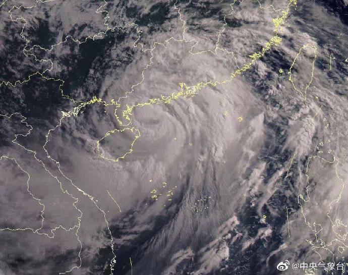
Typhoon "Siaba" landed in Guangdong Daibai
Cover news reporter Teng Yan
On July 2nd, according to the Central Meteorological Observatory, the center of Typhoon "Siaba" No. 3 this year has landed at the electric white coast of electricity in Guangdong at 15 pm today. The lowest air pressure in the center is 965 hundred Pache.
It is reported that the typhoon "Siaba" will gradually shift to move north after landing, and the intensity will gradually weaken. It will weaken and dissipate in Guangxi around 4 days.
Affected by typhoons and its peripheral circulation, from 14:00 on July 2 to 14:00, most of Guangdong, the central and eastern Guangxi, Hainan Island, southeast of Fujian, southern Hunan, and Taiwan Island will be as large as heavy rains. Among them,, of which, of which,, of which, of which,, of which,, of which,, of which,, of which,, of which,, of which,,, of which,,, of which,,, of which,,, of which,,, of which There are heavy rains in the southwestern part of Guangdong, southeast of Guangxi, and Hainan Island, and there are heavy rainstorms (250 to 300 mm). At the same time, the majority of the South China Sea, the southern parts of Guangdong and the coast, the majority of Hainan Island, the southern parts of Guangxi and the waters near the coast, the Xisha and the Zhongsha Islands, the North Bay and the Qiongzhou Strait will have 6 to 8 strong winds. The regional wind power is 9 to 11, and the wind power of the nearby waters or regions passed by the Typhoon Center can reach level 12 to 13, and the gusts are 14 to 16.
Gao Xunzhu, chief forecast at the Typhoon and Marine Meteorological Forecast Center of the Central Meteorological Observatory, pointed out that although the strength of the typhoon landing in my country is medium, it has a strong ability to "rain". The strongest rainfall or cumulative rainfall will be close to or break through the extreme value of the same period, and the cumulative precipitation in local areas can reach 400 to 600 mm.
"Concentration of heavy rainfall periods and extensive influence" is also the characteristic of this typhoon. South China will appear in the rainfall area of heavy rain and above. Some areas will overlap in some regions during the period of this year's "Dragon Boat Water" in South China, especially in particular, especially Most of the western Guangdong, eastern Guangxi, and Hainan Island, causing high risk of disaster.
In addition, Typhoon "Avey" this year has been generated on the 1st. Although the "double typhoon" dance situation has been formed on the sea, Typhoon "Avey" has no direct impact on "Siaba". The Central Meteorological Observatory predicts that "Avey" will move north to west at a speed of 20 to 25 kilometers per hour. The strength changes are not large or slightly enhanced. It will be moved into the East China Sea in the night of the 2nd and gradually moves to the northeast. , And around the 6th, towards the coast of western Japan.
- END -
Quanzhou: strongly promoting inspection and rectification quality to improve quality and efficiency
Recently, the inspection agency of the Quanzhou Municipal Party Committee conscientiously implemented the central government's spirit of strengthening inspection and rectification and the use of docum...
The Beijing Winter Olympics bring fire and snow sports, 7 -year -old flower skating teenager prepares for the provincial games

Falter skating teenagers are training. Photo by intern reporter Tan ZuxianThe Yang...