How big is the world, how strange geographical questions are
Author:Youth Shenzhen Time:2022.06.14
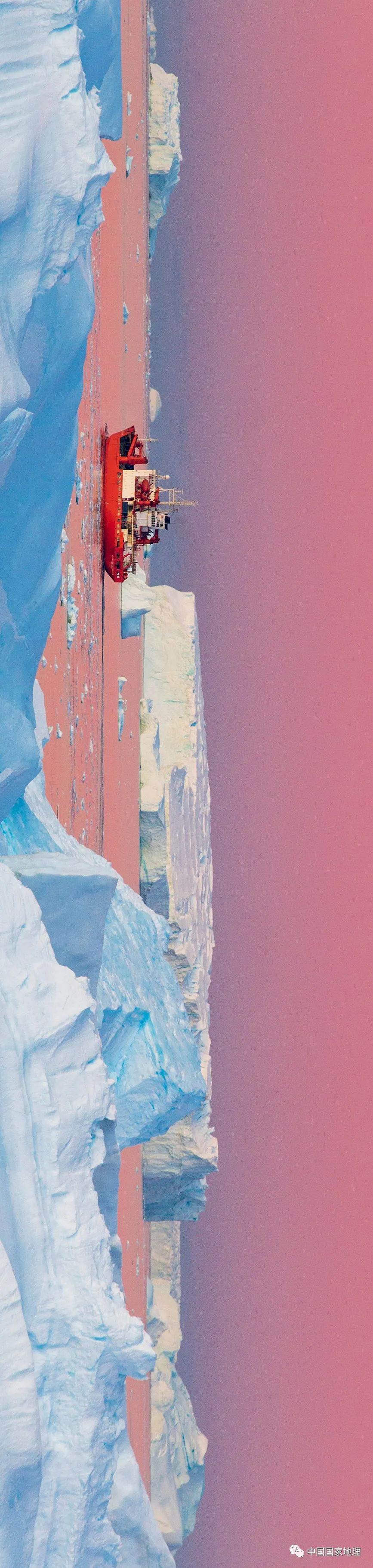
Twilight formed a pink "Venus Belt" near the horizon, and a ice -breaking boat shuttled carefully between the iceberg jungle. (Picture from "China National Geographic" December 2016)
The world's great wonders. Geography is a discipline that is all -encompassing. Life is geographical everywhere, so many people think that the geography is "unreasonable", which is "metaphysics".
Indeed, the geography is rich, and there can be basic life knowledge, or Gao Xuan's universal concept, mountains and rivers, plants, soils, wind and clouds ... all are within its research scope. Therefore, if you want to be geographically good, read more, and increase your knowledge, it is important. Today, Geography Jun will take you to see those wonderful scenes and questions. (Reminder: There are several questions at the end of the article to challenge your imagination)
Balanced stone, natural "earthquake clock"
Click here to read the answer
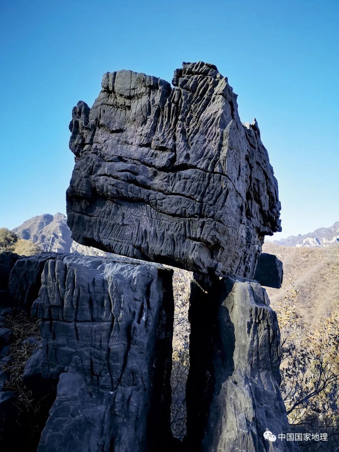
Wind stones are more academically called balanced stones. In fact, it is a special category in the balanced stone. It refers to the balanced stone that can be shaken- "the wind is slightly moving, the wind stops the stone."
Sometimes, people can push the wind and stones with their palms, so that they can shake. To do this, you need to meet several conditions. First, the base under the wind stones must be hard rocks, and the boulder wind pressed on the soft soil cannot be blowing; the second is that the shape of the wind is close to the ellipsoid Or the ball, so the contact area of the wind stones and the base rock is very small; the third is that the contact surface of the wind and the base is not flat, and often there is just a small plate -shaped small shallow concave. It is this inconspicuous small shallow concave that helps the wind Shi Shi to lose its balance when receiving a certain external force, and it can also restore the balance in time and looks like a tumbler.
Balanced stones have not been strict for a long time. Whenever a boulder is raised by a small fulcrum, it looks crumbling, and when it is in a balanced state, people collectively refer to it as a balanced stone.
Picture from "China National Geography" in June 2021
The wind in the picture was discovered in Niu Dazhai, Jiyuan, Henan. It was extremely narrow because of the crowded cliffs, but it was more amazing than its own. After it was discovered and exposed in December 2020, it was immediately promoted to be a hot "net red"; it was less than 3 months of red. In February 2021, it was pushed down by good people and no longer existed. However, its prosperity has attracted many people's attention to the landscape of balance stones. Photography / Li Nan
In fact, various balance stones in nature are not uncommon, but they are not close to the places where we live, so they are even more strange.
If you want to know where to see various balance stones, then you can try to summarize from the perspective of geology: rock column -shaped balance stones appear in the developmental straight column -shaped volcanic rock or shallow rock area; the balanced stone formed by spherical weathering often appears in Granite areas, especially places with sparse vegetation; glacier drifting balancing stones appear in the fourth quarter glacier activity; mushroom stones appear in deserts and strong and weak interoperability sediments.
Ballast and balanced stone: dangerous as tired of eggs, crumbling
Picture from "China National Geography" in June 2021
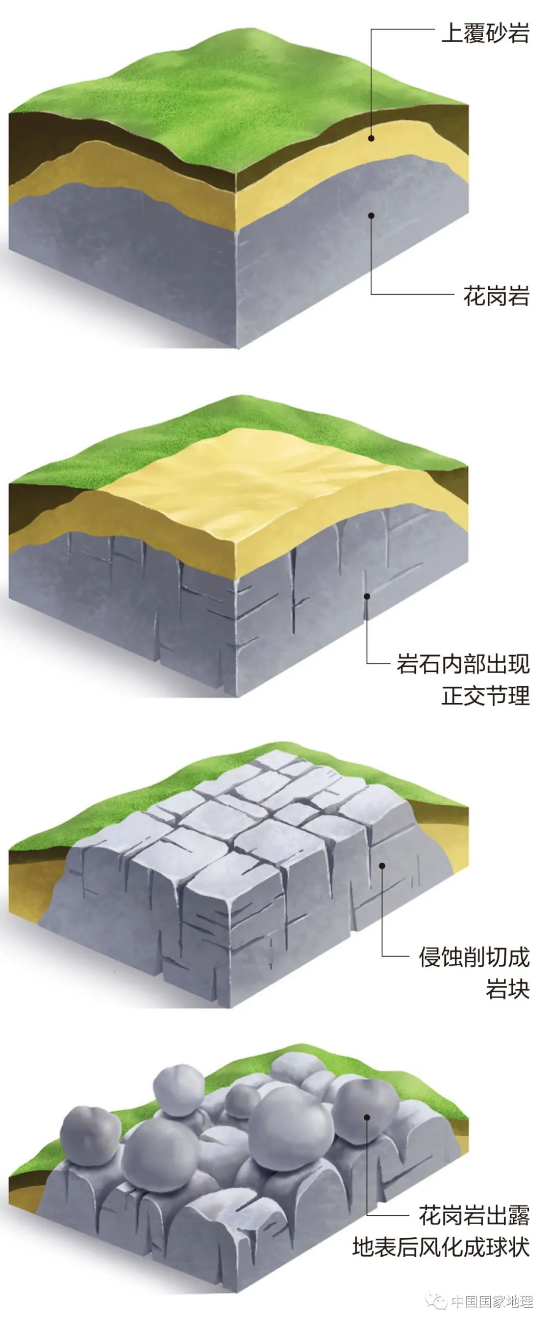
Many of the balance stones we see daily are roughly spherical. The spherical rock is cut with the plane of the base rock, and the contact surface is very small, which is easy to form a trend of critical eggs. Most of these balanced stones are formed by the ginseng ball -like wind. The so -called spherical weathering refers to the erosion and cutting of the groundwater along a large number of orthodontic joints that are perpendicular to each other inside the granite. The rock of many regions or cubes is cut inside the rock layer. Eclipse and erosion are easier, so spherical rocks are formed in the end. Drawing / Tan Xiguang
The natural phenomenon of the most connected with balance stones should be an earthquake. The earthquake is one of the reasons for the balanced stone, but also the murderer who destroys the balanced stone. Moreover, the process of making and destroying occurs instantly, unlike the water cutting, wind erosion and sea erosion, it takes a long time.
It is conceivable that in areas where earthquakes are occurred, the time to maintain stability in balance stones will not be too long. So that geologists believe that there will be no long -term existence of balanced stones on the earthquake.
Starting from this concept, balance stones are used as "earthquake clocks" to detect the intensity and frequency of earthquakes that have occurred in a region in history to understand the geological construction conditions here. This is a very important basis for people to build large -scale construction projects such as dams and bridges here in the future, especially the risk assessment of sensitive projects such as oil pipelines and nuclear power plants.
Rose Lake, Romance of Salt Lake

Click here to read the answer
From December to January of the following year, it is the most beautiful time of Rose Lake. Due to the chemical reactions of the sun and the microorganisms in the water and the rich minerals, it presents pink like satin, and the name of Rose Lake also comes from this.
Unlike many salt lakes in the world, the salt of Rose Lake is not naked on the surface of the lake in the form of salt shells, but instead of salt crystal and deposit on the bottom of the lake. The lake of Rose Lake is very shallow, with an average of only one meter deep, which provides convenient conditions for people to pick salt from the lake, and also creates the unique salt mining landscape of Rose Lake.
Up: the world's main "Rose Lake" landscape distribution map

Below: my country's Fourth Salt Lake and the main "Rose Lake" landscape distribution map
Picture from "China National Geography" in May 2021
Australia, Senegal, Tanzania, Spain, Bolivia and other countries, these foreign rose lakes are distributed: one is basically distributed in coastal areas, and the other is mostly warm salt lakes (the temperature in winter is 10 ° C -20 ° C). The distribution of rose lakes in my country is largely different from foreign countries: First of all, most of our rose lakes in China are distributed in drought and semi -arid areas inland in the west. - 10 ℃).
In the dry and semi -arid areas of western my country, due to the scarcity of precipitation and huge evaporation, the lake is generally developed from freshwater lakes, half salt water (micro -salt water) lakes, and saltwater lakes. Salt lakes and salt lakes are also vividly metaphorized to late lakes or older lakes. If the salt lake develops down again, as the amount of water decreases, it will usher in the end of life -eventually becoming dry salt beach (or sandy lake).
In the process of formation and evolution, salt lakes are always changing due to the constraints and influences of various factors in nature. Especially the lake water body, affected by the geographical environment and climate factors, not only often changes in water volume, but also the chemical composition of water is constantly changing.
In our country, there are two well -known geographical division lines that are familiar with, which are divided according to the precipitation lines of the year. The dividing line in the humid area, the latter is dividing the boundary line of semi -humid and humid areas. However, there is also a very meaningful equal precipitation line -500 mm and other precipitation lines. my country's salt lake is mainly distributed in areas with an annual precipitation of less than 500 mm (the viewpoints such as Academician Zheng Mianping). It can be said that the precipitation line such as 500 mm is a "Hu Huanyong Line" (hereinafter referred to as the "Hu Line") that divides the distribution of salt lakes in my country -west of the line, distributed with most of my country's salt lakes. This line is actually the "lab" distributed by rose lakes in my country -the main rose lake in my country, all in the west area of this line (only individual rose lakes such as Jiechi in the east area).
Summer Lake Jizurgde presents a strong rose color

Place of shooting: Jilin Desert, Cuban, Inner Mongolia
Picture from "China National Geography" in May 2021
In the midsummer in August, Lake Jun Ge Ge, located in the hinterland of Badan Jilin Desert, Inner Mongolia, was influenced by factors such as water temperature, water volume and salinity in the lake. Rose Lake. Photography / Lin Lizhen
Abstract painting, masterpiece of glaciers
Click here to read the answer

提起美国的阿拉斯加州,大部分人脑海中浮现的可能都是它北部广渺的荒原、变幻的极光、巍峨的雪山等,但在阿拉斯加的东南部地区,这一片狭长地带,有着诸多精彩绝伦、 Landscape for ice.
The ancient glaciers shaped the "background color" of the fjords in southern southern Alaska, while modern glaciers developed more landscapes formed on it: blue ice, huge glaciers between the valley, huge huge ones on glaciers, huge ones on glaciers. Ice cracks and ice caves hidden under glacier ...
Why choose summer? Because summer is the best time to explore this area -compared to the seasons with raging storms, rainfall or snowfall, summer climate is relatively stable; and summer vegetation is the most abundant. Charm; more importantly, most of the winter snow has melted at this time, and permanent snow can be revealed, which is the most frequent season for glacier activities. Abstract paintings on the earth are painted by glaciers
Picture from "China National Geography" in May 2021
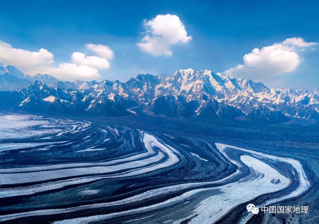
Take a helicopter to look down at the Akutatt Bay in southern Alaska at a height of more than 2,000 meters, and you will be shocked by huge "abstract paintings" on the ground. In fact, this "abstract painting" is a masterpiece of Malas Pina Glacier. The brown -black lines are actually accumulated from the ice cricket of the glacier. Malaspina Glacier is the world's largest foot glacier. This "abstract painting" drawn by glaciers is the representative of the ice landscape of southeast Alaska, but not the only masterpiece. There are many wonderful ice in this area. landscape. Photography / Pan Weihao
Fjord: The iced tongue is rushed into the sea, the forest covers the rock wall
Picture from "China National Geography" in May 2021
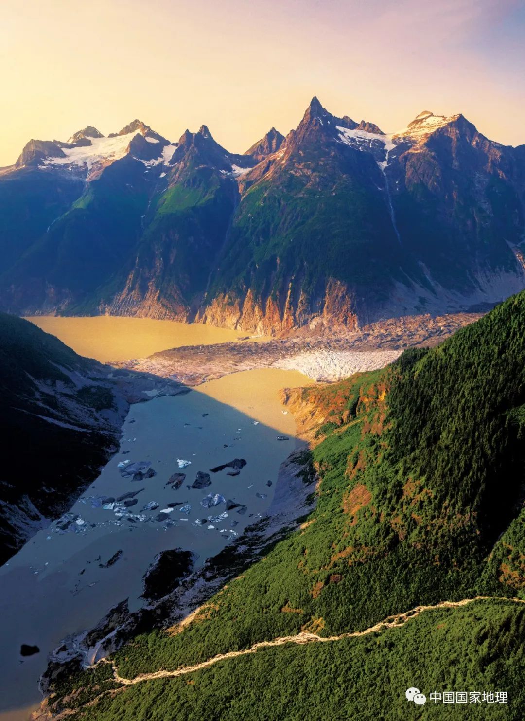
The fjord in southern Alaska is the same as the Norwegian fjord and Greenland fjord. It belongs to the representative of the northern hemisphere fjord, but the characteristics are different. The Greenland fjord is characterized by the huge icefield area and the iced tongue is characterized by directly entering the sea, but the lack of vegetation embellishment; the Norwegian fjord is more beautiful because it is reflected in the green vegetation, but the glacier has basically retracted to the mountain. The advantages of the two in southern Alaska in the southern part of Alaska -there are ice fields with huge ice reserves above the mountain, and the extended glaciers are directly rushed into the sea. There are lush temperate forests growing down in the lower part of the fjord rock wall. Photography / Pan Weihao
Ice hole: fantasy and magnificent, like a different world
Picture from "China National Geography" in May 2021
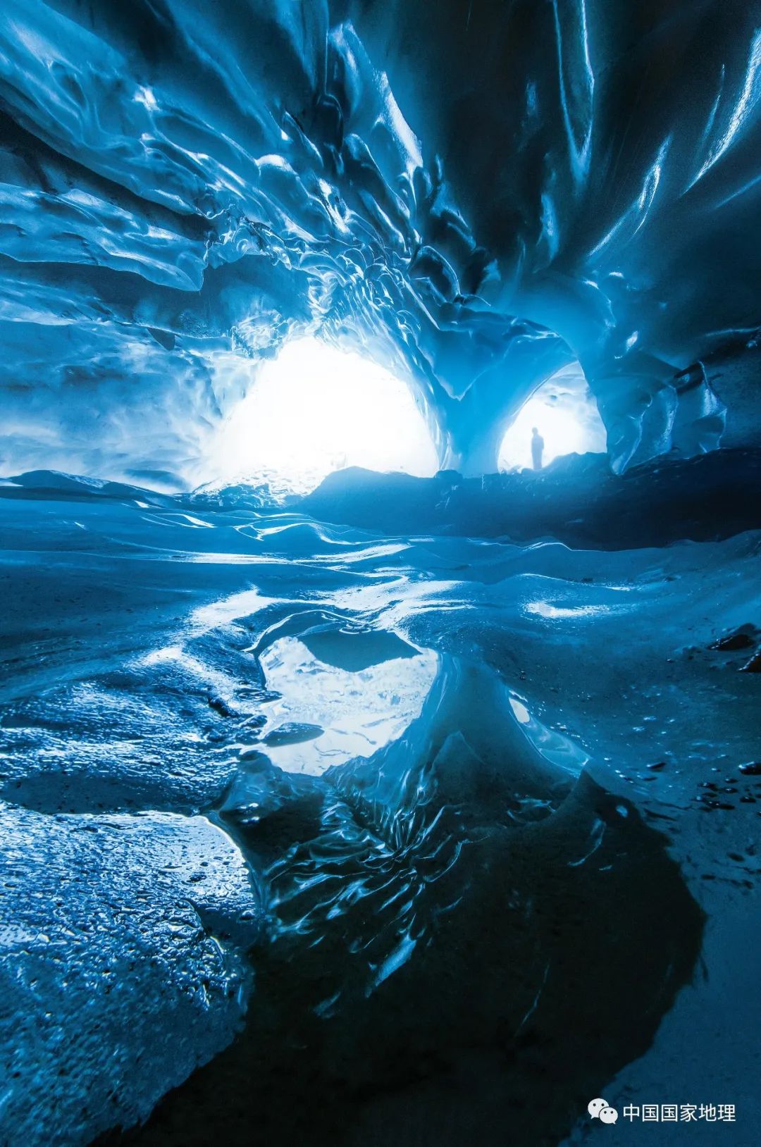
In summer, the mellow water and rain on the glacier will transform into a "excavator" and erode the magical ice caves inside the glacier. On some glaciers with large water melting water, the inner river in the ice is particularly developed, and the chance of forming an ice hole has also greatly increased. When the inner river flows out of the end of the iced tongue, the entrance to the ice hole will form, and most of the cave entrances are like one or low or high arch. Follow the ice cave to enter the inside of the glacier, and sometimes you can even go to the bottom of the glacier. The ice cave has single branches, bifurcation like branches, and caves and caves are connected. Photography / Pan Weihao
Watermelon snow, what happened to the pole?
Click here to read the answer
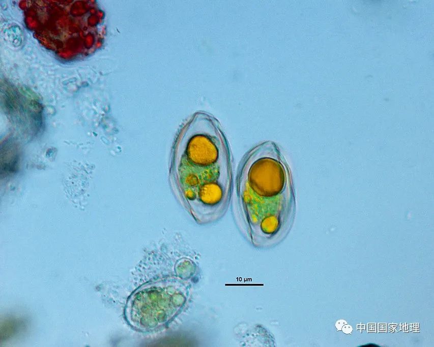
The extreme environment in the polar region allows very few high plants to survive here. What can most adapt to here is the microalga with special anti -temperature special and long -lasting micr -light environment that can resist 24 hours of daylight light.
The microalga is just a collective name. Researchers have found thousands of different microalgae in Antarctica and North Pole. In the Antarctica, there are hundreds of biological microalgae, of which the most common is green algae, diatom, methagulus and brown algae.
Due to the different habitats, microalonia is also popularly called "snow algae" and "ice algae". Snow algae refers to the microalga that grows in the snowy Snow layer of the Antarctic, and they reproduce large -scale on the surface of the snow.
In winter, Snow Algae dormant under the thick snow layer. When the ice and snow melts in the summer, the temperature and light of the temperature and light will explode the explosive growth, dyeing the snow on the color.
Ice algae refers to microalgae living at the bottom of the sea ice, with diatoms. They survive the photosynthesis of the weak sunlight and nutrient salt in the seawater. In summer, Ice algae will also grow explosive growth. The number of Antarctic shrimp, which is eaten by it, will increase. Penguins, sea birds, seals, whales, etc. will follow, and the ocean will soon become vibrant.
Picture from "China National Geography" in December 2020
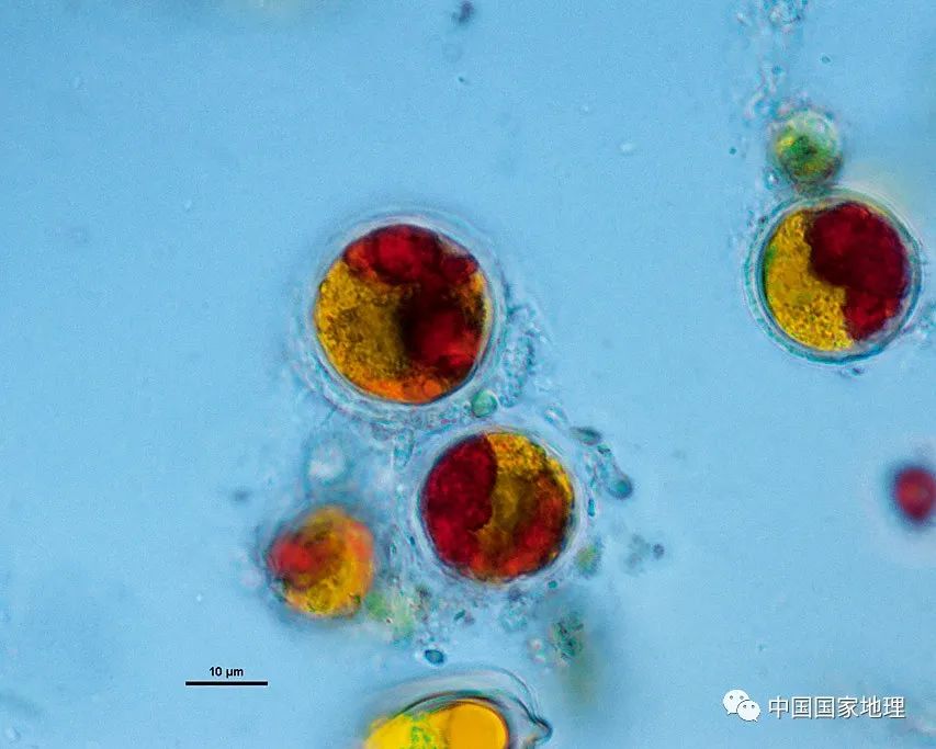
"Watermelon Snow" is a description of the outbreak of red snow algae. In fact, "watermelon snow" can contain a variety of snow algae. The picture shows the two snow algae extracted by researchers in the same "watermelon snow": chlainomonas and chloromonas. The former is a typical red snow algae, and the yellow part of the latter shows that the cells are starting to synthesize pigment and transform red. Photography / Luo Wei
Is the outbreak of Antarctic Snow Algae Is the result of the warming of the earth's climate? The answer in the scientific community is more cautious. Because high temperature in summer is not the only factor that makes snow algae explosion, light, appropriate pH and sufficient nutrients can play an important role.
Picture from "China National Geography" in December 2020
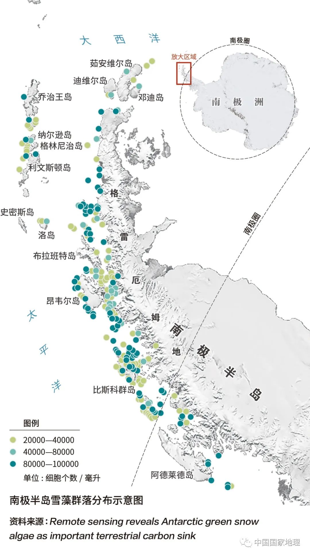
Although some people noticed this phenomenon of Xuezao very early, there were few research on it. In May 2020, a research team at the University of Cambridge University used the remote sensing images of the European Meteorological Satellite to monitor 1679 snow algae communities north at 68 degrees south latitude of the Antarctic Peninsula. According to the monitoring results, they produced the first snow algae community distribution map of the Antarctic Peninsula, and marked the average concentration of different community snow algae cells. Do you think the above topic is not strange enough?
Try to challenge these geographical questions
[Click the picture to see the HD picture]
Click here to read the answer

[Click the picture to see the HD picture]
Click here to read the answer

[Click the picture to see the HD picture]
Click here to read the answer
[Click the picture to see the HD picture]
Click here to read the answer
- END -
Luoyang Yiyang: "Two Cleansing and One Bare" allows the masses to enjoy the green shore green
Top News · Henan Business Daily reporter Fu Shoupeng correspondent Li BinghuiThe ...
Weihai Municipal Human Resources and Social Affairs Bureau held a symposium on youth talents in the city

In order to fully implement the city's human -social system talent work symposium ...