Can you communicate if you can't move?Beidou short news, you are my god
Author:Institute of Physics of the Ch Time:2022.09.06
Recently, Xiaobian Xin (SHANG) BAN) Workers (MO) (yu), suddenly saw the official news of Beidou, in fact, it has been a month, maybe it should be said to be an old news

Today, let's take a look at the black technology behind this -the Beidou short news service that is stronger than the operator.
01
Beidou Satellite Navigation System
Bleak
Speaking of Beidou, everyone must be familiar with everyone. Beidou Satellite Navigation System (BDS) is a global satellite navigation system that focuses on national security and economic and social development. And important time and space infrastructure of time and time service. It is widely used in transportation, agricultural and forestry and fishery, hydrological monitoring, meteorological reporting, communication time, power dispatch, disaster relief, and public safety.

The development of the Beidou system has gone through three stages: at the end of 2000, the Beidou -1 system was built to provide services to China; at the end of 2012, the Beidou II system was built to provide services to the Asia -Pacific region; Provide services to the world. Before 2035, it will also build a comprehensive space -time system that is more general, more integrated, and more intelligent.

Let's briefly introduce the early Beidou.
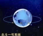
There are only two Earth synchronized satellites on the No. 1 of Beidou, plus a spare satellite, which can only be said to be a satellite radio positioning system. This system technology is less difficult and has less investment.
Beidou -1 positioning system adopts active positioning. During the positioning, the receiver first needs to send the position request signal. The satellite sends a range signal to the service area. The receiver responds to the receiver, and then the distance between the satellite and the receiver is solved by the ground center station. In this way, we get the distance between the receiver and the two satellites, but it is obvious that this is not enough to determine the position of the receiver, so we need to give the high -end data of the receiver. Coordinate value. After getting two distances on the ground, search for digital maps stored at the central station to find points that meet the distance conditions to determine the specific location of the receiver.
The picture originated from Baidu Encyclopedia
The active positioning is a satellite radio -determining business (RDSS), which refers to the need to receive signals during the positioning process. The disadvantage is poor concealment, the solution takes time, and the positioning accuracy is low. Corresponding to the active positioning is the passive positioning, that is, the satellite radio navigation business (RNSS). The receiver only needs to accept the signal from the satellite to complete the positioning here. The No. 2 system and the current Beidou III system are passive positioning systems.
02
Beidou No. 3
Bleak
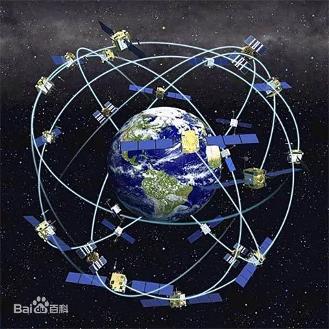
Nowadays, the Beidou we use has reached the third stage. In June 2020, the last satellite launch of the Beidou satellite navigation system was successfully launched, and the Global Networking of the Beidou system was officially completed. On the morning of July 31, 2020, the Global Satellite Navigation System of Beidou III was officially opened and began to provide high -quality navigation positioning services for global users.
At present, the nominal constellation of the Beidou No. 3 is a satellite (GEO) satellite and 3 inclined Earth synchronous orbits by 24 Chinese Earth orbit satellites (meo) satellites (meo) satellites (meo) satellites (meo) satellites (meo) satellites (meo) satellites (meo) satellites. Satellite composition. The Beidou Coordinate System (BDCS) is adopted, and the reference ellipum parameters of the China Geodetic Coordinate System 2000 are used in the 2000 China Geodetic Coordinal System 2000. Beidou Time (BDT) is the time benchmark of the Beidou system. It uses the international unit system (SI) seconds, and the coordination world on January 1, 2006 is the starting calendar at 00:00 00 seconds. At the same time, BDT has established connections with international UTC through UTC (NTSC).
The picture originated from Baidu Encyclopedia
The main function of Beidou is positioning and time. Let's briefly introduce satellite positioning technology here. Common satellite positioning technologies include single -point positioning (absolute positioning) and relative positioning. A single -point positioning requires only one receiver to complete the positioning, and the relative positioning is given the relative position of two or more receivers. Look at the map every day to see where we are using a single point positioning. The typical positioning method of the relative positioning is the real -time dynamic carrier -wave phase differential technology (RTK), which is limited in length, and then talk about it.
03
Single -point positioning
Bleak
Let's briefly introduce the commonly used pseudo -distance measurement method of single -point positioning.
When the receiver is positioned, the pulse signal from the satellite will be accepted. The signal speed is the speed of light. If the time is simply multiplied, the distance between the receiver and the satellite can be obtained. but! This time is uncertain. The satellite and the receiver are all clocks. Ideally, we only need to compare the time for the satellite to send the signal with the time of receiving the signal to get the signal transmission time. In, the receiver can generally only use ordinary quartz clocks. For positioning, it is very inaccurate. After all, the signal is transmitted at the speed of light, and the extremely fine error can get a thousand meters of errors. Therefore, in the actual positioning, there is a deviation in the measurement of the distance, which mainly comes from the bell difference between the receiver and the satellite. Fortunately, this deviation is the same for each satellite. We can consider this deviation during measurement. We call this measurement result as a pseudo -distance, which means that this distance is not a real distance. The pseudo distance can be written as the following form:

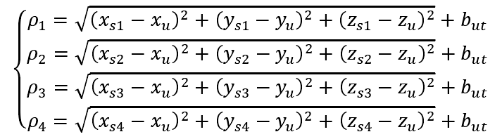
The last item in the formula is the error. XSJ is a satellite coordinate and XU is the coordinate of the receiver. It can be seen that there are four unknown numbers in the pseudo -distance measurement of three coordinates and clock differences. Therefore, I want to ask for solution and need at least four equations.
Pseudo -distance measurement schematic diagram, R in the figure R is actual distance, ε is error | Figure source is based on reference materials
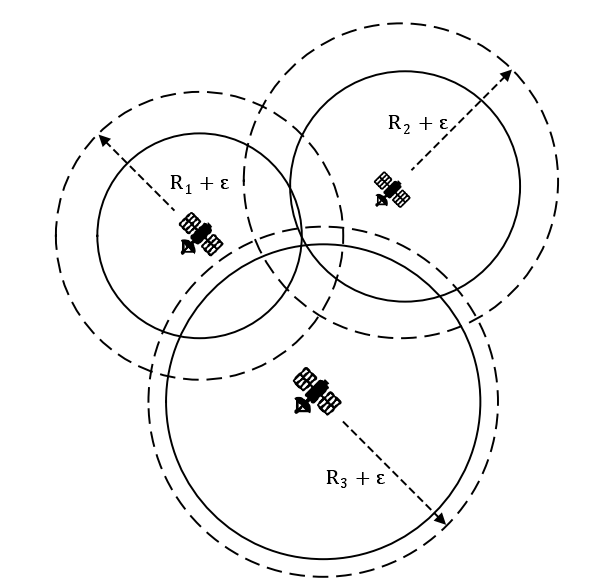
Therefore, in the actual positioning, the receiver needs to receive the signals of at least four satellites, and solve the following equations to get the coordinates of the receiver.
The principle is very simple and clear, is it not easy, because the following is a mathematical problem, how to solve this equation.
This is a non -linear equation. In actual positioning, it is usually approximate. The commonly used methods include the minimum daily method, the Kalman filtering method, etc. It will not be introduced here, and no one will look at it.
Generally, the positioning satellite can broadcast two frequencies signals. Therefore, only one of the frequencies can be used during positioning, or two frequencies can be used at the same time. According to research, the single -frequency single -point pseudo -positioning accuracy of the Beidou satellite navigation system is similar to other global systems, and the dual -frequency single -point positioning accuracy is slightly better than other global systems.

In addition to the difference in clocks, the error of the pseudo -distance positioning is also derived from satellite star calendar, ionizing layer delay, delay of stream layer, and multi -path effects. The satellite star calendar describes the information of the satellite running orbit. View the position and speed of the satellite at any moment at any moment of the satellite. The ionization layer delay and the stream layer delay are errors produced when the pulse signal passes through the atmosphere. The former can make a correction through dual -frequency signals. The multi -path effect means that in addition to receiving signals from satellites, the receiver may also receive reflex signals from the ground or surrounding buildings. These signals may interfere, thereby errors.
Drawing diagram of multi -path effect | Figure originated from reference materials

Traditional single -point positioning (SPP) generally can only reach more than ten meters or tens of meters or even worse accuracy, so it is not considered a high -precision positioning method. In recent years, Precise Point Positioning (PPP) technology, using precision satellite track and precision satellite clock to change correction, and the non -differential wave phase observation data of a single satellite receiver can be located for single -point positioning to obtain centimeter level levels. The accuracy of the satellite navigation industry has received widespread attention and attention.
As for the positioning method of differential waves, it must be next time.
04
Beidou short newspaper
Bleak
Finally talked here. Beidou short newspapers, this is the characteristic function of Beidou, other satellite navigation systems are not unique.
Beidou Shipping originated from Beidou -1. Since 2003, from Beidou -1, Beidou has adopted a RDSS -based system to provide users with short newspaper communication services. Beidou No. 2 still inherits this system and services. On the basis of compatible RDSS systems, Beidou III uses three GEO satellites and uses a broad RDSS system and RNSS + short newspaper communication system to upgrade the short newspaper communication services. You can also implement global short newsletter through the Star Room link. At present, Beidou Global Shipping Document Communication Business has been opened.

Global Shipping Document Communication Schematic Chart | Photo originated from reference materials

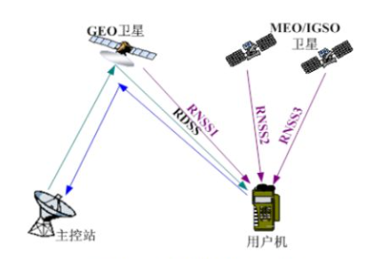
The RDSS system here is the source positioning system mentioned above, and RNSS is the passive positioning. As mentioned earlier, the active positioning system needs to transmit signals to satellites, so Beidou -1 can complete communication tasks like an international communication satellite.
At Beidou III, we innovated in the positioning system. Now users can still use the broader RDSS system to locate, receive a RDSS signal and RNSS1 signal broadcast by a GEO satellite, and receive at least one MEO or IGSO satellite RNSS2 signal at the same time. The receiver is measuring the time difference between the two RNSS signals, and then the parameter is sent to the main control station through the GEO satellite. The main control station uses these parameters to perform the location of the user machine and two -way time. User machines can communicate with the main control station through the GEO satellite. In addition, users can also use the RNSS signal of the Beidou navigation constellation to solve the user position and one -way award. Only using a two -way data transmission capacity of a GEO satellite to communicate with two -way message.
Grand RDSS system and RNSS system+short newspaper communication system schematic diagram | Figure source is from reference materials
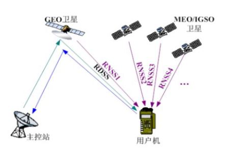
The text communication of Beidou III was upgraded and expanded. The communication capacity is greatly improved. At present, the maximum length of the regional short newspaper service service of Beidou III is 14,000 bits, which is about 1,000 Chinese characters. Global short newspaper text communication services use 14 MEO satellites to achieve global message communication services. Single The maximum length of the short newspaper is 560 Bit, which is about 40 Chinese characters. Terminal transmission power can be reduced below 3W. The success rate of the communication communication of the short newspaper is also very high. According to the evaluation, the power of the regional short newspapers is better than 99.6%, and the success rate of the global short newspaper text communication is 96.46%. Of course, the above is not civilian data. As a heavenly -based communication method, short -news communication has all the advantages of satellite communication, such as all -weather, widely covered by the whole region, and high reliability.
1. Quick response ability, short message communication delay is about 0.5s, point -to -point communication delay is 1 ~ 5s;
2. Strong communication anti -interference, and at the same time use the S/L -band satellite transmission, which can penetrate the flat stream and the stream layer, which can ensure communication under extreme weather conditions;
3. Low equipment requirements, low equipment prices, and high cost performance.
The application of short messages is very wide. Take a few simple examples. The first is navigation and fisheries. Once the accident at the sea was mainly on the satellite phone, the satellite telephone service fee was high, and many small fishing boats were reluctant to use it. Now they can also use Beidou short newspapers. Not only can they communicate, but also navigation positioning services. If you need to work in Gobi and Shenshan Laoshan in the desert, bring a Beidou terminal that can send a short message, and always ensure that communication must be very at ease.
Another typical application scenario is rescue and rescue. In fact, as early as the Wenchuan earthquake, the Beidou short newspapers have been revealed. At that time, it was only Beidou No. 1, but in the disaster area where the post -earthquake branch was fragmented, all communication facilities were destroyed. It was the PLA officers and soldiers carried the Beidou terminal into the disaster area. Subsequent command provides important support.
The Chinese People's Liberation Army in the Wenchuan earthquake | The picture comes from the China Military Network
Nowadays, Beidou and various industries are accelerating the integration. When writing, Xiaobian has found many industries based on Beidou. Beidou, the real country of the country.

Finally, to talk about the theme of this article, we use more positioning navigation services in Beidou daily. Nowadays, mobile phones support Beidou positioning. However, it seems that everyone has just heard of it, but the good news is that in the future, everyone can use the mobile phone to use the Beidou short news. In August of this year, the first domestic mobile phone Beidou short newspaper communication radio frequency base band integrated chip was successfully developed. The chip was jointly developed by China Weapon Industry Group Co., Ltd. and China Mobile Communications Group Co., Ltd., China Electronic Technology Group Co., Ltd. and domestic mobile phone manufacturers. The mobile phone equipped with this chip can use the Beidou system unique to the Beidou system without changing cards, not changing numbers, and increasing external equipment. This means that users can pass information through the Beidou satellite signal in emergency situations to achieve smart phone satellite communication capabilities. "One machine is in hand, always online"
Not to mention, Xiaobian has moved bricks, and strive to use mobile phones equipped with Beidou short messages as soon as possible!
Reference materials:
[1] Zhang Lai. [Beidou] The system can achieve passive positioning? [J]. Weapon knowledge, 2005 (09): 37-39.
[2] Cai Hongliang, Meng Yinan, Geng Yangtze River, Gao Weiguang, Zhang Tianqiao, Li Yan, Shao Lu, Xin Jie, Lu Hongyang, Mao Yue, Yuan Haibo, Liu Cheng, Hu Xiaoyong, Lou Yidong. Beidou III Global Navigation Satellite System Service performance assessment: positioning navigation time, astrolane enhancement, precision single-point positioning, short newspaper communication and international search and rescue [J].
[3] Wang Tenghui. Beidou and 5G Joint Positioning Method Study [D]. Chinese Academy of Sciences (National Academy of Sciences National Time Center), 2021.
[4] Wei Jixiang. Beidou satellite navigation system Expert positioning method Study [D]. Hefei University of Technology, 2021.
Single point positioning and relative positioning
Satellite navigation precision single -point positioning (PPP) technology (Beidou.gov.cn)
Technical Point · Aerospace Beidou No. 3 Regional Short Daily News Communication Service
Short newspaper in Beidou
Heavy | The world's first! The results of Beidou III text communication services are officially released
Edit: Mu Zi
- END -
Cyber Security Propaganda Week | A detachment of the Second Motor Corps of the Armed Police Corps launched a military camp network security publicity week activity

Author | Wang Kankan, Zhao Yujie, Yang JunThe troops have regulations, you have to...
Figure-1660 dispatches!The Russian army launched 62 missiles to fight Ukraine in two days.
[Military Bills Plane] Author: LeleOn June 26, the governor of Kiev, Ukraine, stat...