Aerospace science and engineering aircraft carrier -deduced air -to -air aircraft system helps the first plateau meteorological observation test
Author:Global Times Time:2022.09.18
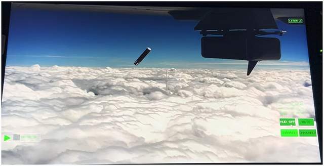
Pick up the surveillance live map (the cylindrical body in the figure is the exploration instrument of the lower investment)
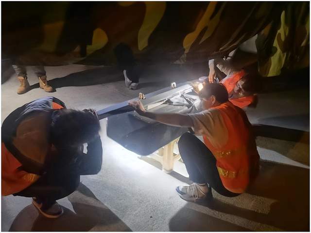
On September 17, the first plateau meteorological observation test of high -altitude large -scale drones in China achieved a complete success under the organization and guidance of the China Meteorological Administration. 23 Aerospace New Meteorological Company of China Aerospace Science and Technology Institute of Aerospace and Industry developed a designated height at the target airspace, and successfully cast 12 in the "China Water Pagoda" Sannan Snow Mountain in the "China Water Pagoda" Sanjiangyuan area. The subordinates of the underwriter, together with other airborne loads, "scan" the atmospheric vertical and lower pads of the Qinghai -Tibet Plateau.
Along with observation data such as cloud system distribution, water vapor structure, wind farm and under -padding conditions in a group of Sanjiangyuan areas, the real time returns to the ground command system in real time, marking the success of my country's high -altitude large -scale drone plateau meteorological observation test.
This is the successful protection of the airborne aircraft in the new aerospace new meteorological company under the airborne airborne system. Since its participation in the "Haiyan Plan" in 2020, it has achieved three consecutive protection. In many years of R & D, the airborne investment -type empty system has gradually formed a series of products, which are tested and used on a variety of drone platforms, and have good generality. This product can play an active role in many industries and fields such as meteorological emergency, disaster monitoring, ecological monitoring, and artificially impact weather.
The Qinghai -Tibet Plateau has a great impact on my country's, East Asia, and even global climate change, but the area is difficult to build a station, the vertical structure and the observation information of the under -pads. It can not only complete the mobility and refined detection of vertical atmosphere of the target area through the airborne and exploration system, but also make the business detection of related areas possible. The vertical atmospheric detection data obtained by the lower investment and exploration system, helping scientists provide valuable data at the same time of the research work of scientific issues such as Sanjiangyuan and "Hometown of Glacier" and the three -dimensional structure of water circulation and water supply. The results of related research will also become an important basis for the decision -making decision -making of the Qinghai -Tibet Plateau water resources and ecological security in the context of climate change.
After the successful first flight, the meteorological department will also focus on the water vapor channel, glacier distribution and glacier area water supply to carry out multi -second aircraft detection to promote the construction of a vacuum observation system with high -performance large drones as the main body. Protective and scientific response to climate change provides richer data. The aerospace new meteorological company explore the air system will continue to provide data services.
(Text/Yang Chuan)
Source: Aerospace Science and Technology Second Hospital
- END -
The northeast of the Ukraine has recovered in many places. Is the battle situation as Western media that has been biased towards Ukraine?| Phoenix Observation
Russia and Ukraine's conflict lasted for 200 days, and the situation in the Halkov...
Japan wants to be familiar with Chinese fighters with Indian military exercises

India's Eurasian Times said on the 11th that India and Japan are strengthening bil...