The surrounding planning and adjustment of the carbon steps of the Guangfo West Ring Line will be developed
Author:Guangzhou Daily Time:2022.09.21
On September 21, the "Guangfo West Ring Station Station (Charcoal Station) and Peripheral Land Use Control Detailed Planning Optimization" made public announcements on the Municipal Planning and Natural Resources Bureau website. In the publicity, comprehensive development of TOD is carried out in conjunction with the charcoal station, optimizing land layout around the site, and adding 37 public service facilities.
The project is located in Chantu Town, Huadu District. The planned scope of the plan to the north, the bustling road in the south, the Huadu Avenue in the west, and the red cotton avenue in the east. The planned area is 6.85 square kilometers. In terms of land layout and adjustment, implement 20 meters wide green belt on both sides of the Guangfo Huan urban land and on both sides of the rails, and adjust the land layout around the orbit. Combined with the comprehensive development of TOD in combination with the charcoal station, optimizing the land layout around the site, the green space, commercial and commercial land on the west side of the charcoal station to commercial and residential land, with a plot ratio of 5.0, a total construction volume of 269,600 square meters; the east side of the charcoal station station; Adjust the land and second -class residential land for primary and secondary schools to commercial and residential land, with a plot ratio of 4.0 and a total construction volume of 391,300 square meters.
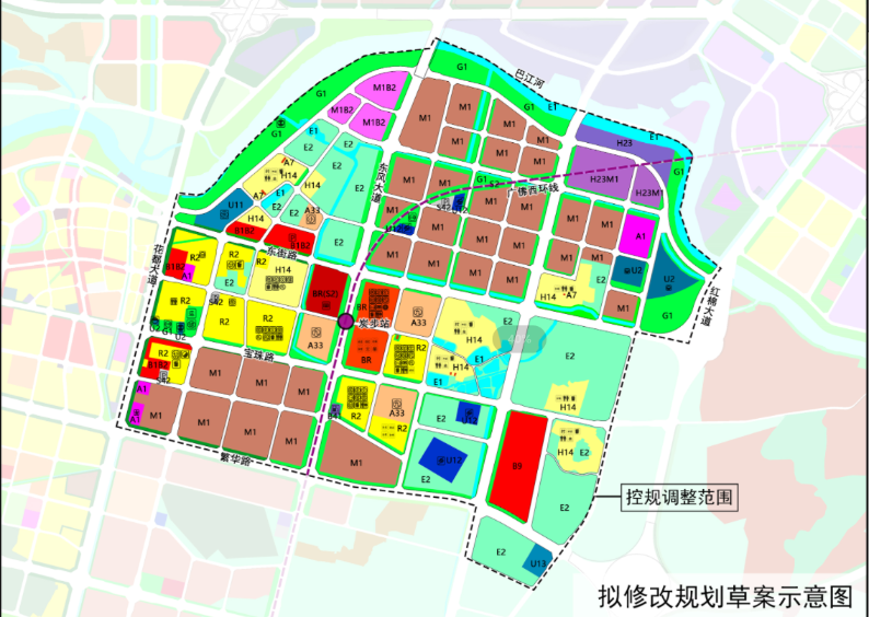
The plan proposes to protect the pattern of Lingnan villages and implement the requirements of traditional villages and cultivated land protection. Implement the protection requirements of traditional villages in Kanshasha, Shihu Village, and restore the construction land of Buyun Village, Shihu Village and Shinan Village. Implement the management requirements of cultivated land, and adjust the second category of residential land on the northeast side of Buyun Village to agricultural and forestry land. A training base for the southeast side is adjusted by agricultural and forestry land to other service facilities. The plot ratio is 3.0, and the total construction volume is 404,700 square meters.
In terms of road adjustment, combined with the protection of the village, the planned branch roads are canceled, and the village roads are planned. The density of the road network of the continuous development area is consistent with the original control regulations, 7.6 kilometers per square kilometer. In terms of supporting facilities, there are 129 supporting public service facilities in accordance with the "Technical Regulations on the Urban and Rural Planning of Guangzhou City", adding 37 new places, of which 1 primary school is added on the south side.
Wen, Picture/Guangzhou Daily · Xinhua City Reporter: Du Juan Guangzhou Daily · Xinhua City Editor: Li Fenghe
- END -
Real estate development project in Luancheng District, Shijiazhuang City can be sold for sale
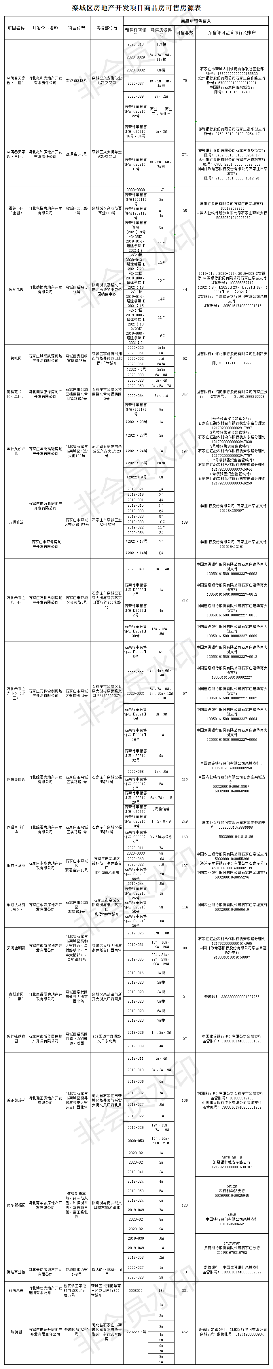
In order to further disclose pre -sale behaviors of commercial housing, to the gre...
Powerful style construction year | The whole province takes the lead!Pay the house to pay the certificate

Yang Licheng, a citizen of Qiqihar City, did not expect that he would become the f...