2022 Government and Enterprises | Navigation, taxi, ordering, autonomous driving ... cannot be separated from it
Author:Shenzhen News Network Time:2022.06.17
What are the geographical information data of surveying and mapping?
Maybe some people will say
not my business
You are wrong
Actually everyone is using it every day
It is closely related to the production and life of each of us
But it's not known to everyone
Such as convenient services such as navigation, taxi, and ordering meals
Autonomous driving, high -speed rail construction, Hong Kong -Zhuhai -Macao Bridge construction, etc.
Implementation of major projects
It is inseparable from precise and detailed space data
This is the geographical information data of surveying and mapping
Native

June 17th
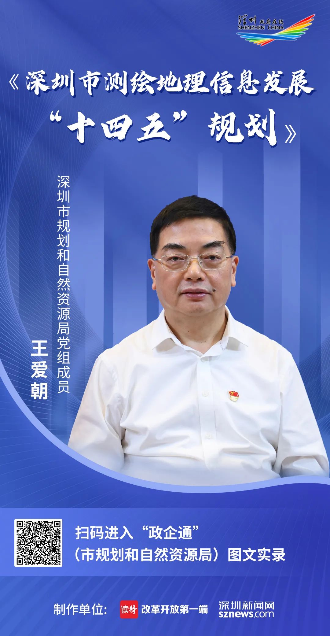
Wang Aizhao, member of the Party Group of Shenzhen Planning and Natural Resources Bureau
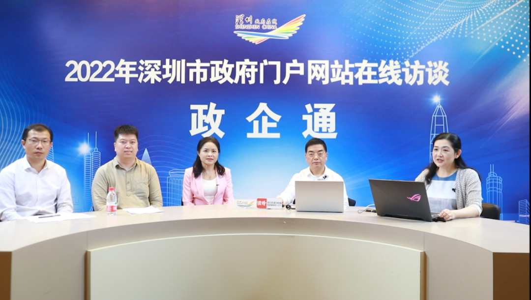
Guest 2022 Shenzhen government online
The second phase of the "Government and Enterprise" interview room
around
"14th Five -Year Plan for the Development of Geographical Information in Shenzhen"
Expand online exchange
This interview
Director of the Director of the Surveying and Mapping Management Department of Shenzhen Municipal Planning and Natural Resources Bureau
Wu Shaofen presided over
Video please watch
According to Wang Aizhao, the "Fourteenth Five -Five Five" plan for surveying and mapping geographical information has been approved by the municipal government in October 2021. The goal of the plan is to "form data time and space, production intelligence, customization of service, and standardized organizational management information service guarantee System ", the content includes four major tasks, 16 planning indicators, 6 major projects, more than 40 projects, and several highlights:
The first is to comprehensively enhance the cooperative service capabilities of Shenzhen surveying and mapping geographic information. Specifically include the Daowan Area Service Remote Sensing Application Center, and supplement the "shortcomings" of the basic surveying and mapping of the Shenzhen -Shanshan Special Cooperation Zone, and promote Shenzhen and surrounding surveying and mapping facilities and data production collaboration.
The second is to promote the transformation and transformation of basic surveying and mapping. Specifically, including the establishment of a variety of data products and technical systems, and encouraging the exploring the Socialization services of the Beidou foundation to enhance the system.
The third is to establish an innovation system with an enterprise as the main body, guide the cultivation of industrial innovation ecological chains, and enhance the ability of geographical information integration and application innovation capabilities.
The fourth is to focus on the advantages of the legislative system of Shenzhen Special Economic Zone, propose the formulation of regulations on the management of surveying and mapping for the Special Economic Zone, and fill the gap in the legislative legislation of surveying and mapping.
Wang Aizhao said that he came to Shenzhen in the early 1990s. At that time, the country was still the "simulation surveying and mapping" stage. The topographic map was still mainly paper. In 1996, Shenzhen took the lead in entering the "digital surveying and mapping" era. In the country, the first urban CORS station was established. The first GPS was used to carry out urban standard measurement. The first digital chemotherapy technology was used to produce. This not only improves the measurement accuracy, but also greatly shortens the construction period.
After 2000, Shenzhen launched the city's geographical information system construction and moved towards "informatization surveying and mapping". In 2002, under the leadership of Academician Guo Renzhong, he took the lead in putting forward the idea of the "open space basic information platform" across the country. At present, the platform service department has reached more than 100 and won the "2012 World Geographic Information Outstanding (Application) Award".
In recent years, Shenzhen has opened the pace of "intelligent surveying and mapping" to achieve breakthrough results. The "China High -precision Digital Datrama Construction" project led by Academician Li Jiancheng's team of academicians has won the first prize of national science and technology progress. "Establishing" is an important verification item; in addition, Shenzhen has built the first domestic real -world real -life three -dimensional space bottom plate in China, which uses a variety of technologies to automatically model three -dimensional results. The accuracy and efficiency are very high.
In general, Shenzhen has always adhered to the spirit of reform and innovation and continuously promoted the work of surveying and mapping geographic information.

Wang Aizhao takes us to review
Shenzhen's surveying and mapping geographical information business for nearly 40 years
After development
Interview entering the exchange link
The live broadcast invited 3 units representatives
They are
Chen Ming'e, chief engineer of Shenzhen Zhongdi Software Engineering Co., Ltd.
Fengtu Technology (Shenzhen) Co., Ltd. CTO Shen Zhichao
He Biao, Deputy Dean of the Institute of Smart City, Shenzhen University
Wang Aizhao made a on -site answer to the question from the unit representative, let us review together
Ask 1

During the "14th Five -Year Plan" period, what are the key areas of Shenzhen's geographical information industry development? What are the ideas and measures taken to promote industrial development? What are the considerations in the localization of technical equipment?
Answer 1
The planning of Shenzhen's industrial development includes the fields of satellite applications, high -precision maps, autonomous driving, and smart city construction. Plan the industrial development ideas and measures:
The first is the industrial development environment. Promote the development of surveying and mapping management legislation, improve the management and mapping market and industry management, and create an industrial environment.
Second, from the perspective of the security of the industrial chain, promote technical independent controlling and encouraging domestic equipment, and encourage major engineering projects to use localized technology and equipment.
The third is to attach importance to local standardization. Guide local standards for three -dimensional modeling, high -precision maps and other fields. It is expected that both China and Fengtu can participate.
The fourth is to guide and promote cross -border development of enterprises. Promote the integration of scientific and technological industries such as aerospace and information services, and promote the transformation of new technological achievements.
Fifth, create a data market environment. Promote the market -oriented configuration of factors in the field of geographical information and cultivate the data factor market.
Ask 2
How to understand the "real three -dimensional" proposed by the country? During the "Fourteenth Five -Year Plan" period, how does the municipal level be carried out in the real -life three -dimensional construction at the city level?
Answer 2
The "real three -dimensional" of the state is to put the point and surface in the topographic map, which is similar to the three -dimensional entities corresponding to the real world, and gives it the only "ID card". The real 3D turns 2D 3D, so that the architecture is three -dimensional, and more intuitive display can be displayed on the ground, underground and other visual display.
During the "Fourteenth Five -Year Plan" period, Shenzhen will continue to make efforts to create a national model:
First, the real -life three -dimensional refinement modeling is covered in the city, and the MESH models, vegetarian models, monomerization and other models are continuously updated;
The second is to use three -dimensional basic geographical information as the framework, integrate various natural resources information, support the construction of three -dimensional three -dimensional time and space database of natural resources, and realize the effects of effective integration and historical evolution of the special elements of land and space.
The third is to further deepen the application of three -dimensional space analysis, expand the application of three -dimensional visualization, fine evaluation, and three -dimensional approval of natural resources, and strive to form a leading batch of leading three -dimensional application demonstration projects.
Ask 3
How to resolve conflicts of confidentiality of geographical information in surveying and mapping geographical information, and what measures will be taken during the "Fourteenth Five -Year Plan" period?
Answer 3
The confidentiality and application contradictions of surveying and mapping are imperative. The state now encourages relevant units to actively develop geographical information confidentiality processing technology. At present, our bureau is conducting a pilot safety application of three -dimensional model results, and cuts in from three aspects:
The first is classification and grading. Product classification, element layering and application classification of the three -dimensional model results, and the development of differentiated products is reasonable and dense.
The second is to distinguish the scene. Study the differentiated needs of three -dimensional models in different scenarios, and formulate security application strategies on demand.
The third is technical autonomous and controllable. Strictly adhere to different security red lines such as secrets, government affairs, and openness, and carefully evaluate the safety and secret levels of diversified three -dimensional products, and ensure that data processing and data service technology are localized and safe.
Many netizens at the interview site left a message in the background
Communicate and interact with guests
Wang Aizhao's expectation
Implementation through planning
Continuously improve the development level of surveying and mapping geographical information
Example for building a socialist modern power city for Shenzhen
Provide strong basic support
Related introduction

The "Shenzhen Government Online" was built and operated by the Shenzhen Municipal Administration Service Data Administration. In order to implement the major strategic deployment of the "dual district" construction, further strengthen policy interpretation, enhance the interaction of government and enterprises and the public, and continue to optimize the construction of the business environment. The two series of two series of political and civilian and "government and enterprises" are planned to carry out 12 issues to provide practical and effective services for enterprises and the public.
Source: Shenzhen Municipal Administration Service Data Administration
Shenzhen Planning and Natural Resources Bureau
Shenzhen Government Online, I Shenzhen Public Account, Shenzhen News Network
Edit: Ma Jingxin
- END -
Typical distortion, divine turning over!How to avoid negative effects on positive energy reports?
Source | 解 庖 w NEWSAuthor | Zou YuqinOn weekdays, many news titles are moving. T...
China Petrochem
Sinopec Chongqing Jiangnan Petroleum focuses on the refueling gas station service to improve the 100 -day competition, continues to improve the quality of service, take multiple measures, build the