Tianlang Qi is clear, a new round of precipitation from west to east will affect our district from west to east
Author:Inner Mongolia weather Time:2022.08.31
See you in August
The last day of August
Different from the hot summer at the beginning of the month, the sun is hard to the sun like fire
Different from the night in the middle of the month, the rain is cold and cold
Most of the weather in Inner Mongolia today
The heavenly gas is clear and autumn, high gas describes
It seems more appropriate

01
Weather briefing
Autumn all took over the "command stick" of the weather
◆ ◆ ◆
Tonight to tomorrow
The overall weather in Inner Mongolia is cool and pleasant
Most of the district is dominated by sunny weather
◆ ◆ ◆
Tomorrow to the day after tomorrow
A new round of precipitation affects our district from west to east
There are precipitation
There are middle to heavy rain in Baotou City and Ordos City
Affected by rainfall
The temperature also drops slightly
◆ ◆ ◆
Night the day after tomorrow
The precipitation area gradually moves eastward
Most of the central and western parts in the central region have precipitation
02
Yesterday weather
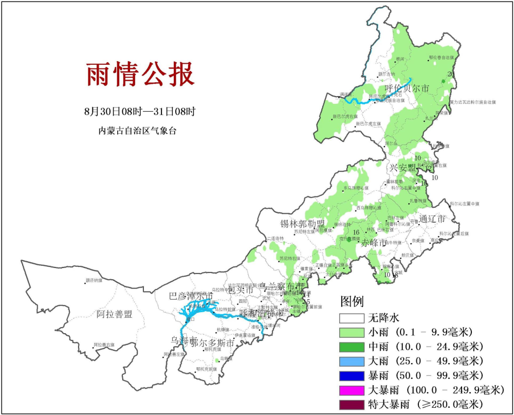
yesterday
Inner Mongolia precipitation mainly appears in the eastern region
Mainly to medium rain
Maximum precipitation appears
Hulunbuir City Molida Vadar Autonomous Banner
The maximum precipitation is 19.7mm
03
Recent weather summary and outlook
I. Our district this year's precipitation concentration is significantly advanced in advance. The rainy season is increasing in the east, and the development of the central region decreases.
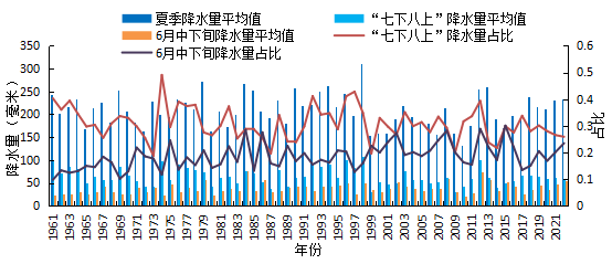
"Seven or eight" is a period of concentrated precipitation in our district. The precipitation accounted for nearly 30 % of the annual precipitation. Storms and hail and other strong convective weather was frequent, which is a key period of flood prevention.
In the past 63 years, the precipitation during the period of "seven or eight" has generally decreased significantly, but after the 1990s, it fluctuated greater and more extreme. During the "seven or eight" period, the proportion of precipitation accounted for the total summer precipitation was decreasing. The average proportion of the past 10 years accounted for 27%, which was 4%from the annual (1991-2020). The proportion has increased significantly, and the average proportion in the past five years has declined but still shows a increase. (figure 1)
The start time at the beginning of the rainy season in the eastern part has an advanced trend. In the past 10 years, the average start date is 8 days earlier, and the length of the rainy season is 20 days older. The rainfall during the rainy season is 69 millimeters more than the year. The date is 3 days later, the rainy season length is 3 days less than usual, and the rainfall during the rainy season is 13.4 mm less than usual.
Fig
2. This year's rainy season in the eastern part is early, and the central part is late. The central rainy season has not yet ended.
The east of our district entered the rainy season on June 12, and the start date was 13 days earlier; the east in the east end of August 20, the end of the end of the end is close to the year; the rainfall of the rainy season is 66.7 mm more than usual, which is more than 13 since 1961. The central region entered the rainy season on August 14, and the start date was 22 days later, the latest since 1961; as of now, the rainy season in the central part has not yet ended.
3. It is expected that the first frost date of the major agricultural areas in the main agricultural area in September is 1 to 5 days earlier than the year earlier.
Chu Frost Date Forecast: Hulunbuir City, Xing'an League, northern Tongliao City, northern Chifeng City, and northeast of Xilingule League appeared from August 25th to September 25th, 1 to 5 days earlier than usual; the rest of the rests appeared; other areas appeared in the rest of the area; the rest appeared in other areas. From September 25th to October 20th, it is 1 to 5 days later than usual. (figure 2)
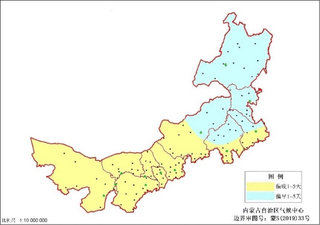
Figure 2 Trends prediction of frost date in early 2022
Average temperature trend: The average temperature in the region is 0 to 1 ° C higher than usual.
The trend of precipitation: Southeast of Hulunbuir, Xing'an League, Tongliao City, East Chifeng City, Southern Ordos, Wahai and Alashan League southeast of precipitation are 0 to 20 % more than usual; ~ 2 %. (image 3)
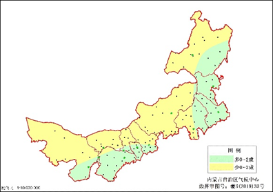
Figure 3 Prediction of precipitation trends in September 2022
Fourth, follow and suggest
The first is to predict that there are more precipitation in the main agricultural areas in September. The early precipitation in the south of the central and western parts in the south of the central and western regions, and the soil is good. It is necessary to prevent the strong precipitation of the land.
The second is to predict that the emergence of frost in the northeast of Xilin Guole League and east of the area is slightly earlier than usual. On August 27th, the first frost appeared in 10 stations in the central part of Hulunbuir City, the southeast of the Silin Guole League, and the southeast of Ulanchabu City. The first frost date was 5-21 days earlier. It is necessary to prevent the adverse effects of early frost freezing weather on agriculture.
04
Weather in the next three days
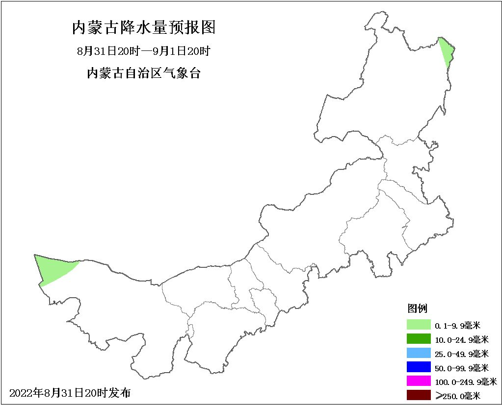
20:00 on the 31st to 20:00 on 01
The northeast region of our district is cloudy and sunny, and the western part of the western region is sunny and cloudy. The western part of the Alashan League and parts of the northeast of Hulunbuir are decentralized small showers. Southeast wind, the west of the north of the east is 4 and 5.
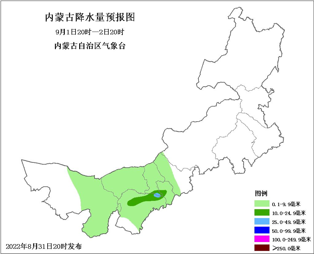
20:00 on 01 to 20:00 on 02
Cloudy in the western region of our district and cloudy in most areas in the central and eastern parts, there are light rain or thunderstorms in the east of the Eastern, Wuxi City, and Ordos to the west and north of the city of Ulancha. There are medium rain in the southeast of Baotou City and the west of the central part of Hohhot City. There are heavy rain in parts of parts of the southeast of Baotou City and part of Ordos. The sunny is cloudy; the western part of the western part is 4 and 5 southern winds, and the 4th and 5th west winds in the north areas in the east.
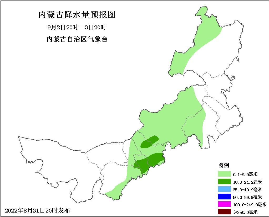
20:00 on 02 to 20:00 on 03
The western parts of the western part of our district are cloudy and sunny, and most of the central and eastern parts are cloudy. There are light rain or thunder showers in eastern Ordos, eastern Baotou to west of Chifeng City, western and north of Hulunbuir City., Southern and Northeast of Wulanchabu City, and some areas in the western parts of Xilingule League, there are medium rain. The above -mentioned local areas are accompanied by thunderstorms, short -term strong precipitation and other strong convective weather.Grade west wind.End

The copyright of this article belongs to the "Inner Mongolia Weather"
Reprinted, please indicate the source and timeliness
Unreasonable reprints and tampering responsibilities must be investigated!
- END -
Silk Road Dialogue | Hacquent "Killer in the Water" is also an ecological education class

Strange Fish in Ruzhou, Henan, caught:Ten 2 crocodile crickets, which are harmless...
A week of funds inventory: more than 3 billion yuan of main funds from net inflow into the breeding industry, and the northbound capital high position Tianqi lithium industry

On July 8th, the Shanghai Stock Exchange Index maintained a sorting situation thro...