The super typhoon "Xuan Lannuo" gradually approached. Zhejiang issued a prompt letter to start IV -level response in many places!What impact will "Xuan Lannuo", which is "v", has a sharp turn?
Author:Voice of Zhejiang Time:2022.08.31
Source: Comprehensive Zhejiang Voice reporter Zhang Zezhang, Cai Jikang, Wang Xian, Central Meteorological Observatory, Zhejiang News, Zhejiang Weather, Zhejiang Emergency Management, Zhejiang Maritime Earth, Zhejiang Ocean Monitoring and Forecast Center, China Weather Network, etc.
The copyright belongs to the original author, if there is any infringement, please contact it in time
Typhoon Xuan Lannuo No. 11 this year
It has been strengthened to super typhoon level
And in the next 4-5 days, it will be maintained at this intensity level
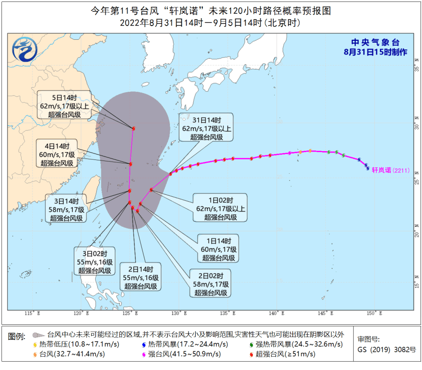
At 14:00 today (31st), Typhoon "Xuan Lannuo" was located at 25.4 degrees north latitude and 129.1 degrees east longitude. It is about 170 kilometers south of Naha, Okinawa Prefecture, Japan. The southwest moves, and the intensity will not change much. It is expected that it will be moved to the sea on the southeast of the East China Sea on the 3rd.
Meteorological experts said that "Xuan Lannuo" has a strong intensity and may move less for a long time in the later period. In the next five days, it will have a continuous impact on the East China Sea area. Past vessels should be transferred to the safe area in time. In addition, the current situation of the atmospheric circulation is complicated. There is also tropical low -pressure activity on the south side of "Xuanlan Nuo", especially during the steering period, affected by the cold air eastward, subtropical high -pressure changes, vortex interoperability, etc. It is not ruled out that along the sea along our province. The Provincial Meteorological Observatory will continue to surveillance and analysis and report in time.
According to the "Zhejiang Province Flood Control and Drought Resistance Emergency Plan", the provincial defense index was decided to launch an emergency response to typhoons at seasons at 17:00 on August 31. All local departments are requested to do a good job in the defense of typhoon "Xuan Lannuo".
Zhejiang Provincial Defense Independence Office issued a prompt letter
Typhoon "Xuan Lannuo" has a strong intensity, a large path uncertainty, and a severe defense situation. On the afternoon of August 31, the Zhejiang Provincial Defense Independence Office issued a prompt letter--
All localities and departments must resolutely overcome the paralysis and relaxing thoughts, and do a good job of typhoon prevention. In particular, coastal cities such as Wenzhou, Taizhou, Ningbo, Zhoushan, etc., in accordance with the most unfavorable situation, the spirit of the people's life and property is highly responsible for the safety of the people.
We must resolutely implement prevention and control measures. All localities and departments should encrypt the frequency of discussions and judgments, pay close attention to the development and changes of typhoons, analyze and judge major risks in the jurisdiction, and make preventive preparations. As long as maritime ships return to Hong Kong to avoid wind within the prescribed time, strengthen the control of the seizure of ships, non -power vessels, and construction vessels; maritime breeding personnel and maritime engineering operators should evacuate to the safe area in time to ensure safety; Dedicate the transfer of tourists; the inspection of risk areas such as Haitang Dam, Shantang Reservoir, Small Basin Floods, Geological Disasters, and Urban Waterlogging in the coastal areas should be strengthened, and prevention and control measures are implemented in a timely manner.
We must resolutely transfer the personnel of the risk area. All localities should strengthen personnel transfer and hedging resettlement, organize personnel transfer in dangerous areas in advance, especially focusing on disadvantaged groups such as the elderly and children to ensure that they should "turn early and turn around." Essence
It is necessary to resolve the implementation of the responsibility for the anti -Taiwan prevention. The responsible persons in the coastal area should be in place quickly, strengthen the duty on duty and inspections, and find that the danger is reported in time and properly disposed of. Major dangerous conditions and disaster conditions occur in various places. It is necessary to deal with the provincial prevention office as soon as possible.
Emergency response to Zhejiang Starting Grade IV Defense Force
The Zhejiang Maritime Safety Administration launched an emergency response to the Grade IV defense station at 8:45 on August 31. The Provincial Marine Monitoring and Forecast Center issued a blue alert, affected by Typhoon No. 11 "Xuan Lannuo" (super typhoon).
Near -sea waters: Hangzhou Bay has a light wave of 0.5 meters to 1.0 meters. It will increase to light to the middle wave from 0.8 meters to 1.4 meters tomorrow evening; there will be a middle wave from 1.4 meters to 2.2 meters in northern Zhejiang. From the mid -to -large waves from 3.2 meters; there are mid -to -2.5 meters in central Zhejiang to large waves from 1.6 meters to 2.5 meters, and tomorrow evening will increase to a large wave from 2.8 meters to 3.8 meters; there will be 1.8 meters to 2.8 meters in the southern Zhejiang to large waves. From 3.0 meters to 4.0 meters to huge waves.
Near -shore waters: Zhoushan and Ningbo are from 1.0 meters to 1.6 meters of light to Zhonglang, and tomorrow evening will increase to 1.6 meters to 2.5 meters. From 1.8 meters to 2.8 meters of large waves; Wenzhou has 1.0 meters to 1.6 meters of light to Zhonglang, and will increase from 2.0 meters to 3.0 meters from the middle to large waves tomorrow evening. Near -shore sea wave early warning level is blue.
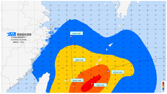
Wave Police News
It is expected that from the afternoon of the 1st to the 6th, a big storm process will occur in the Zhejiang waters, and the largest will appear in the 4-5 days. The 6.0-9.0 meters of wild waves will appear in the Zhejiang waters. It is expected that the sea wave warning level will reach the yellow or yellow level.
A response to typhoons in many places in Zhejiang
Ningbo Coastal Starting Class IV DIA emergency response
According to the trend and development trend of typhoon, the Ningbo Maritime Safety Administration decided to enter the Class IV station emergency response from 8:45.
Wenzhou launched a typhoon prevention level IV emergency response
According to the "Wenzhou Flood Control Station Drought Resistance Emergency Plan", Wenzhou's defense index was decided to launch a typhoon prevention response at 10 o'clock on August 31. In addition, Wenzhou City has launched a water -defense -level emergency response at 16:00 on August 30.
Taizhou launched a typhoon prevention level IV emergency response
According to the emergency plan of the Flood Prevention of Taizhou City, Taizhou Defense Index decided to launch a sea -level emergency response at the sea of typhoon prevention at 10 o'clock on August 31. Fourth questioning super typhoon "Xuan Lannuo"
From the current forecast, it is expected that by September 5th, "Xuan Lannuo" will maintain a super typhoon level at a time of time or a week. In addition, when it travels west to my country, it may turn north to show the "V" direction.
Why is "Xuan Lan Nuo" so strong? What impact will its peculiar direction bring on our country?
01
Why is the strength so strong and what are the characteristics?
According to Hu Xiao, chief meteorological analyst of China Weather Network, from the perspective of cloud maps, the typhoon "Xuan Lannuo" has clear wind, complete and compact ring structure, not large but strong. Players, strength cannot be underestimated.
At 15:00 on August 31, Typhoon "Xuan Lannuo" satellite cloud map. (Picture source: National Satellite Meteorological Center)
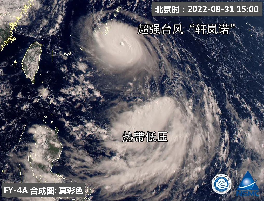
"Xuanlan Nuo" was generated on the afternoon of August 28. It was upgraded to a super typhoon in the early morning of the 30th. It is expected that it will remain at the level of super typhoons on September 5th for a week. Fortunately, the process of "Xuanlan Nuo" super typhoons is all at sea, with limited impact on land.
"‘ Xuan Lannuo ’can become the first super typhoon this year, one is the high sea temperature, and the other is that the high -rise outflow conditions are good." Hu Xiao explained.
At present, in the sea area of Typhoon "Xuanlan Nuo", the sea temperature is higher than the same period of the same year, and it is basically 31-32 ° C. The typhoon before this year is not as high as the subtropical high pressure, and the sea temperature is not high. In addition The overall atmospheric circulation situation is beneficial to it, and the high -level outflow conditions are good, so that "Xuan Lannuo" has good energy support. Therefore, it can become the first super typhoon this year and maintain it at this level for a long time.
02
Why is it unique and rushed to the word "V"?
Judging from the current typhoon movement path released by the Central Meteorological Observatory, whether "Xuan Lannuo" can eventually land in my country still has suspense. In the future, it first moves stable towards the south of the south and continues to approach the coast of East my country in China; subsequently, or rushed northward in my country to the north, showing a unique "V" trend.
The main reason for the "Xuanlan Nuo" path may be that it may change its subtropical high pressure.

Hu Xiao explained that at present, the increased cold air activity in the north has increased, making the intensity of the subtropical high pressure show a decline; in the later period, as the cold air moves eastward, it may open a "channel" in the area where the subtropical high -pressure control is controlled to break it into two two into two two. part. Therefore, the critical period of Typhoon "Xuan Lannuo" in the future depends on when this "channel" can be opened.
From the current forecast, from September 2nd to 3rd is the critical period of the "Xuanlan Nuo" path. The subtropical high pressure will break from this night to tomorrow. After that, "Xuan Lannuo" will stay in Taiwan for a period of time in Taiwan, and then turn north by the auxiliary high -pressure east section from September 2nd to 3rd.
03
Will it an annexed new typhoon become stronger?
There is currently a tropical low pressure on the south side of "Xuanlan Nuo", which may become Typhoon "Plum Blossom" No. 12 this year. But even if the typhoon "plum blossom" is generated, it will be a "short -lived" typhoon.
Hu Xiao said that because the tropical low voltage is close to "Xuan Lannuo", it is expected that from tomorrow, the "Fujiwara effect" of double typhoons will occur between the two. The influence of each other shows a trend of approaching or even merging. At present, the intensity of "Xuan Lannuo" is greater, so it will have a greater attraction to tropical low pressure and may annex it. After the annexation, the volume of "Xuan Lannuo" will become larger, the wings will be fuller, and the scope of influence will be expanded, but the strength will not be "overweight."
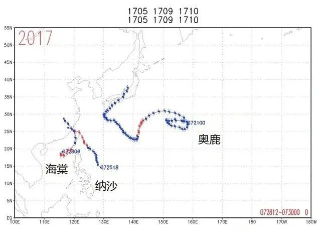
There are many cases of "entanglement" between the two typhoons, and the scientific name is "Fujiwara Effect". "Fujiwara effect" means that the two tropical cyclones can have an mutual impact when within 1500 kilometers apart, rotating along the axis in the direction of the clockwise direction. Generally, a strong tropical cyclone dominates the weak tropical cyclone and is right. The path has an impact.
Taking 2017 as an example, "Olympic", "Nasha" and "Begonia" have been generated. The two typhoon centers of "Nasha" and "Begonia" are rotated counterclockwise, which is manifested as the East Typhoon moved to the northwest. The western typhoon spins in place in the northeast of the South China Sea. When "Nasha" landed and disappeared, "Begonia" moved from north to northwest, and then disappeared inland. The path of "Nasha" and "Begonia" is a typical example of "Fujiwara effect". However, "Olysu" and the other two typhoons have little impact.
04
How will it affect my country?
At present, the impact of "Xuan Lannuo" on my country has not yet fully developed. In the process of continuously approaching my country to China, due to its peripheral circulation, it is expected that from September 2nd to 3rd, there will be strong winds in coastal areas such as Taiwan, Fujian, and Zhejiang. Level 8, gusts or even stronger or even stronger. The strong wind will also cause dry weather in East China and the development of meteorological drought. However, if "Xuan Lannuo" is closer, it will bring rainfall in the later areas.
If "Xuan Lannuo" will turn north in the future, it will also have a strong impact on the waters such as the East my country Sea and the Yellow Sea. At the same time, it will "join forces" with the cold air in the north, which does not rule out the possibility of the impact of wind and rain on some areas of the northeast of my country next week. Impact on Zhejiang
1
Influence
From today to September 2nd, the wind power of the East China Sea will be strengthened to level 9-10, and from level 10-12 on the 3-5 to level 14-16, the typhoon center can reach level 17 or above through the nearby waters.
2
Coastal wind and rain influence
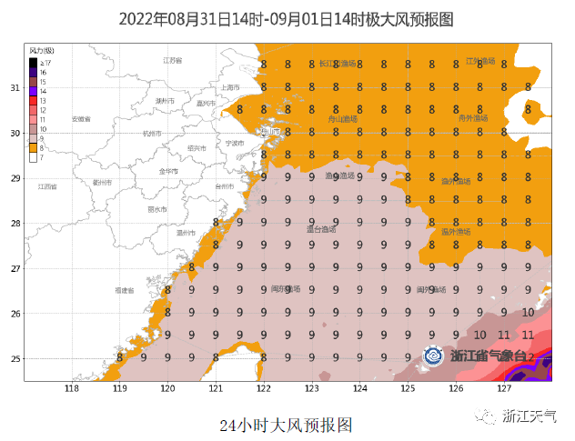
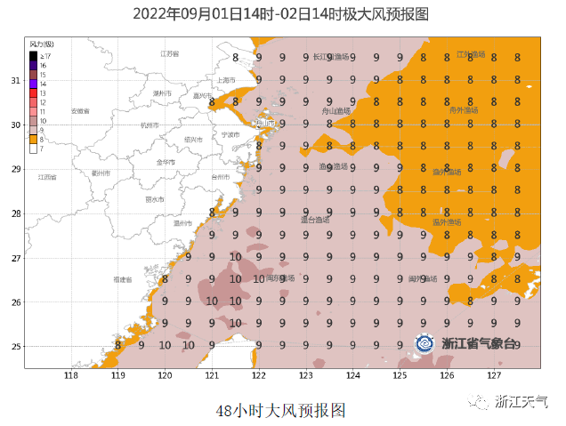
Tomorrow (September 1) will increase the wind and wind on the coast to level 9, 4-5 days of gusts can reach 10-12 levels, and the local level exceeds 13 levels. In addition, there are showers in the coastal areas on the 2-4th.
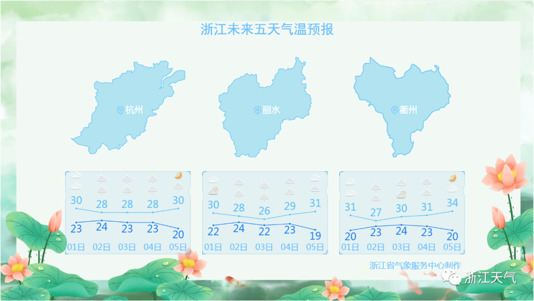
Zhejiang weather trend
Today's affected by cold air southward
Cold and cold group intersection
This evening to night
The rainfall concentration area moves south to south of Zhejiang area
Tomorrow day
Affected by the circulation of cold air and the periphery of the typhoon
Precipitation in coastal areas will be obvious
Provincial Meteorological Observatory 16 forecast
From this evening to night: there are shower or thunderstorms in southern Zhejiang area, and there are some short -term heavy rain in the thunderstorm area; other areas are cloudy to yin.
Tomorrow: The province is cloudy to overcast, and the coastal areas will have a partial shower in the yin at night.
The day after tomorrow: There are shower in the coastal areas, and there are shower in other areas in other areas.
5 days ago
Affected by cold air, typhoon, and rainwater
High temperature 鼓 高 高 高 高
The highest temperature in the province is hovering around 30 ° C
It will even fall below 30 ℃
Come to the word "2"
After 5 days
The weather will turn from the current rain to fine
But being controlled by cold high pressure
High temperature is still difficult to appear
There will be one at that time
A comfortable feeling with the sun but not hot
- END -
Extraordinary comment | Men's job hunting is "like a thief", extremely ignorant and rude!

Polar News commentator Wu ShuangjianOn August 23, a netizen in Shenzhen, Guangdong...
At the beginning of school, China Eastern Airlines ushered in the peak of returning no -accompanying children at Guangzhou Baiyun Airport
At the beginning of school, many children who were reunited with their loved ones ...