This year's first super typhoon "Xuan Lannuo" is coming.
Author:Xinmin Evening News Time:2022.08.31
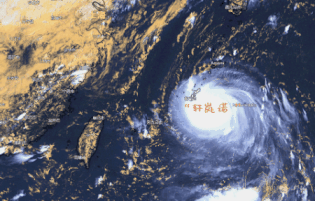
Super typhoon
"Xuan Lan Nuo"
Near our country
Typhoon "Xuan Lannuo" latest developments
Typhoon Xuan Lannuo (Super Typhoon Level) was generated on the Northwest Pacific Ocean at 2 pm on August 28. After generation, it developed rapidly. In the early morning of the 30th, it was strengthened to a super typhoon level, becoming the first super typhoon this year.
In the next 4 to 5 days, "Xuan Lannuo" will still maintain the strength of the super typhoon level, with a maximum strength of more than 17 or more (62-70 meters/s).
Xinmin Evening News reporter learned from the emergency management department today that "Xuan Lannuo" is approaching the East China Sea quickly. It is expected to move into the southeast of the East China Sea on the night of September 3, and maintain super typhoon levels for a long time. , Bohai Sea and coastal areas may have a heavier impact.
The National Defense Office and Emergency Management Department pointed out that the typhoon "Xuan Lannuo" has a great intensity, which will maintain the super typhoon level for a long time, and the development trend in the later period will be complicated. Essence
The center of "Xuan Lannuo" at 2 pm is located on the northwest Pacific Ocean of about 990 kilometers southeast of Shanghai (25.4 degrees north latitude and 129.1 degrees east longitude), the maximum wind near the center is above 17 or above (62 meters/s), the lowest center is the lowest in the center The air pressure is 915 Baipa, and the seven -level wind ring radius is 220 to 230 kilometers.

Why is Xuan Lan Nuo "unique position
Show the word "V"?
Whether "Xuan Lannuo" can eventually land in my country still has suspense. In the future, it first moves stability towards the south of the west and continues to approach the coast of East my country in China; subsequently, or rushed northward in my country to the north, showing a unique "V" trend.
The main reason for the "Xuanlan Nuo" path may be that it may change its subtropical high pressure. At present, the increased cold air activity in the north has increased the intensity of the subtropical high pressure. In the later period, as the cold air moves eastward, it may open a "channel" in the area where the subtropical high -pressure control is controlled to break it into two parts. Therefore, the critical period of Typhoon "Xuan Lannuo" in the future depends on when this "channel" can be opened.
From the current forecast, from September 2nd to 3rd is the critical period of the "Xuanlan Nuo" path. The subtropical high pressure will break from this night to tomorrow. After that, "Xuan Lannuo" will stay in Taiwan for a period of time in Taiwan, and then turn north by the auxiliary high -pressure east section from September 2nd to 3rd.
Typhoon "Xuan Lannuo" influence
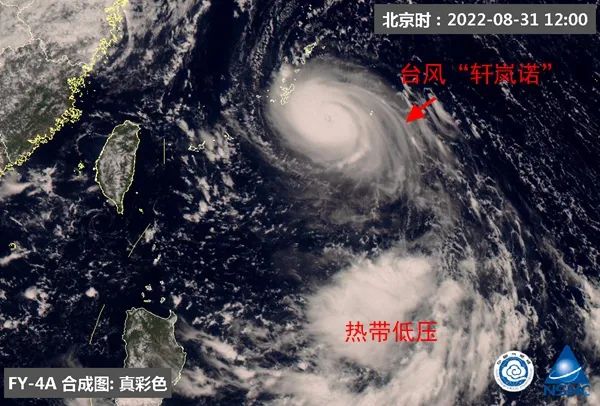
At 12 o'clock on August 31, Typhoon Xuan Lannuo Satellite Cloud Map. (Picture source: National Satellite Meteorological Center)
At present, the impact of "Xuan Lannuo" on my country has not yet fully developed. In the process of continuously approaching my country to China, due to its peripheral circulation, it is expected that from September 2nd to 3rd, there will be strong winds in coastal areas such as Taiwan, Fujian, and Zhejiang. Level 8, gusts or even stronger levels, or even stronger. The strong wind will also cause dry weather in East China and the development of meteorological drought. However, if "Xuan Lannuo" is closer, it will bring rainfall in the later areas.
If "Xuan Lannuo" will turn north in the future, it will also have a strong impact on the waters such as the East my country Sea and the Yellow Sea. At the same time, it will "join forces" with the cold air in the north, which does not rule out the possibility of the impact of wind and rain on some areas of the northeast of my country next week. China Weather Network reminds the public to pay attention to the forecast and early warning information released by the local meteorological department and do the corresponding prevention work in advance.
Affected by the typhoon "Xuan Lannuo", there will be a continuous wind from the 1st to 5th. The wind will gradually increase from the time of Shanghai tomorrow. It is expected that the impact of the strong wind will last until the 6th.


01
East China Sea Wind
Affected by the circulation of the "Xuanlan Nuo", there is a continuous wind process in the East China Sea in the East China Sea: 1 to 2, the maximum gust of 9 to 10, and the maximum gust of the southeast of the East China Sea on the 3rd on the 3rd. At night to 5th, windpower in the northern part of the East China Sea gradually increases to level 12-14, and the wind power passed by the Typhoon Center will reach 16-17 levels.

02
Shanghai wind and rain influence
The wind will gradually increase to level 4 to 6 of the 4 to 5 gusts tomorrow. The gusts of gusts along the coast along the river will continue to increase from 6 to 7, and the wind will continue to increase on the 4th to 5th. It is expected that the impact of the wind will continue until the 6th. Affected by the periphery of the typhoon, the city has more than 2 to 5 days.
03
Stay concerned
At present, there are tropical cloud group activities on the south and east side of "Xuanlan Nuo", which has a certain impact on the path of "Xuanlan Nuo" in the later period; "Xuanlan Nuo" has strong intensity and complicated paths. Please pay attention to the typhoon dynamics and the latest forecast in time. information.
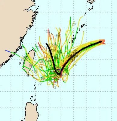
Each numerical forecast for the future path and intensity of "Xuanlan Nuo"
Different predictions


Focus on defense
The long -term duration of the wind in the East my country Sea in China has a great impact on sea transportation and water operations. At the same time, it is necessary to pay attention to preventing the wind on land and coastal areas, reinforce or remove the buildings that are easily blown by the wind, and properly resettle outdoor items that are easily affected by the wind.
Weather trend
Tomorrow (September 1) ushered in school day, Shanghai is on the northern edge of the subtropical high -pressure, mainly cloudy to overcast weather. The temperature is between 23 and 29 ° C.
On the 2nd to 5th, due to the circulation of the periphery of the typhoon "Xuan Lannuo", the rainy weather in Shanghai, at the same time, the wind was significantly increased. Please pay attention to the latest forecast information in time.
From the 6th, the typhoon "Xuan Lannuo" was far away. Shanghai was mainly cloudy weather, and the temperature rose slightly, and the highest temperature was around 30 ° C.Xinmin Evening News (Du Yao, a reporter in Beijing), comprehensive Shanghai Weather and China Weather Network

Edit: Tang Meng
Xinmin Evening News Xinmin Evening News is a newspaper with temperature, strength, dimension, and scale.It started in Nanjing in 1929. It is based on Shanghai in the next long term and faces the whole country. Looking at the world.It is the earliest newspaper in Mainland China and has been published continuously so far, with a daily circulation of 1 million copies.

764 original content
the public
- END -
Sanhe Police captured an online fleeing person who was suspected of contract fraud

On June 23, 2022, the police of the police station of the Yingbin North Road Polic...
[Implement safety responsibility to promote the development of safety] Theory+practical training is full of dry goods

From August 4th to 5th, the Taiqi Temple Banner Red Cross Society and Joint Emerge...