It's cool!The lowest temperature in Shanghai today is only 23.3 ° C. Is it early autumn?The super typhoon "Xuan Lannuo" is approaching, and the path is complicated to see… 懵 懵 懵 懵 懵 → →
Author:Look at the news Time:2022.08.31
The last day of August
The weather is finally cool!
According to the "Shanghai Early Warning Release" news
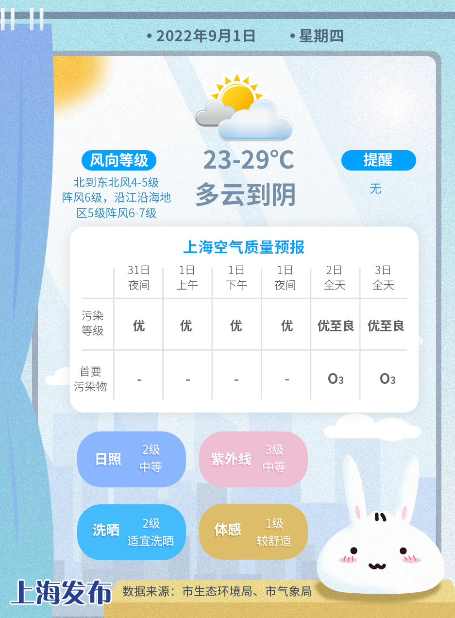
Xujiahui Station today's lowest temperature is only 23.3 ℃
The highest temperature during the day is 26.8 ℃
It is the coolest day since mid -June

and
Shanghai will still be cool tomorrow
All weather temperature is expected to be 23 to 29 ℃
Shanghai crickets will usher in school in coolness
Many friends in Shanghai are feeling emotional
▽
Temperature drops suddenly, sultry and heat disappear
Is this going autumn?
According to China Weather Network
The latest national autumn process chart
Most of the southern areas have not opened the autumn process yet
Jiangnan and other places will go to autumn in October

Autumn in the sense of meteorology needs to wait
Just feel a wave of autumn in advance
The next few days
Just focus on the typhoon
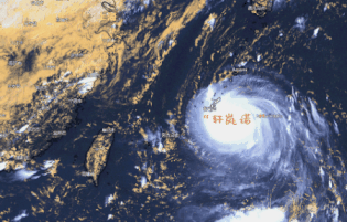
Super Typhoon "Xuan Lannuo" approaching
Close to East China on September 3
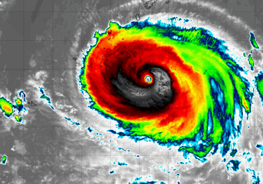
Typhoon No. 11, "Xuan Lannuo", is the first super typhoon in the Pacific Ocean in the Northwest so far this year. From the satellite cloud map, it is not large, the cloud body is compact, and the typhoon eyes are clear. It is really small figure and large energy.

Xuanlan Nuo "latest developments
Today (31st) at 2 pm, "Xuan Lannuo" is located on the northwest Pacific Ocean surface of 990 kilometers southeast of Shanghai (25.4 degrees north latitude, 129.1 degrees east longitude), and the maximum wind near the center of the center (62 meters/ 62 meters/ In second), the lowest air pressure in the center is 915 hundred Pache, and the seven -level wind ring radius is 220 to 230 kilometers.
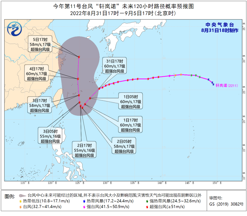
It is expected that "Xuan Lannuo" will move southwest at a speed of about 20 to 25 kilometers per hour. From September 1st to 2nd, the east of the Ryukyu Islands stagnate or rotates, and then moved north to the west. On the 3rd, it moved into the waters in the southeast of the East China Sea on the 3rd, and then moved north to the north.
In the next 4 to 5 days, "Xuan Lannuo" will still maintain the strength of the super typhoon level, with a maximum strength of more than 17 or more (62-70 meters/s).
How does it affect Shanghai?
The wind will gradually increase tomorrow
As far as the current forecast of the Central Meteorological Station, it is expected that by the next Monday (September 5), "Xuan Lannuo" will always maintain a super typhoon level, time or a week.
Fortunately, the process of "Xuan Lannuo" super typhoon is all at sea, with limited impact on land.
Affected by typhoons, it will continue to have a strong wind next Monday. Among them, from the night of September 3rd to 5th, the wind power in the northern part of the East China Sea gradually enhanced to level 12 to 14, and the wind power passed by the Typhoon Center will reach 16 to 17.
"Xuan Lannuo" has a main impact on the periphery circulation on Shanghai
The Shanghai Central Meteorological Observatory predicts that the wind will gradually increase from tomorrow, and it is expected that the impact of strong wind will continue until next Tuesday. The specific impact is as follows:
In terms of wind power, from September 1, Shanghai wind power has gradually increased to level 4 to 5 gusts, and gusts of gusts along the coastal areas of the river; September 4th to 5th, wind will continue to increase. It will last until the 6th.
In terms of rain, there are more than rain from September 2nd to 5th.
Under the influence of wind and rain, the hot weather in Shencheng pressed the pause keys. By next Monday, the highest temperature in the city was stable below 30 ° C, and the lowest temperature was only 23 to 25 ° C.

The Shanghai Meteorological Bureau reminds that the long -term duration of the wind in the East my country Sea in China has a great impact on sea transportation and water operations. At the same time, it is necessary to pay attention to preventing the wind on land and coastal areas, reinforce or remove the buildings that are easily blown by the wind, and properly resettle outdoor items that are easily affected by the wind.
"Xuanlan Nuo" path is complicated
Pay close attention to moving trends
Although "Xuan Lannuo" has no direct impact on Shanghai, its movement still needs our close attention. Because of the tropical cloud group activities on the south and east side of Typhoon, it has a certain impact on the path of "Xuan Lannuo" in the later period, which has caused the numerical forecast of various countries to have a large prediction of the "Xuanlan Nuo" future path and intensity.
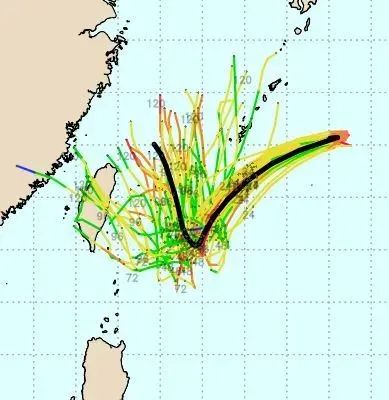
The numerical forecasts of the "Xuan Lannuo" in the future path and intensity of "Xuanlan Nuo" are large
The Central Meteorological Observatory believes that when "Xuan Lannuo" travels west to my country, it may turn north to show the word "V".
The main reason for the "Xuanlan Nuo" path may be that it may change its subtropical high pressure.
If "Xuan Lannuo" will turn north in the future, it will have a strong impact on my country's East China Sea and the Yellow Sea. At the same time, it will "join forces" with the cold air in the north, which does not rule out the possibility of the impact of wind and rain on some areas of the northeast of my country next week.
Super Typhoon Impact
A response to emergency response to the Grade IV defense station in many places in Zhejiang
Zhejiang Maritime Safety Administration launched IV -level station response
Typhoon 11 this year (super typhoon) "Xuan Lannuo" at 0800 on August 31 at 26.1 ° north latitude 131.1 ° east longitude, that is, 1052 kilometers from Wenzhou, the center's maximum wind is 17, and the central air pressure is 915 hundred Pacao , Move the direction of the west and southwest, the movement speed is 25 kilometers per hour.
After the typhoon was generated, the Zhejiang Maritime Affairs Bureau paid close attention to its dynamics and development trends. At 0845 on August 31st, the emergency response of the IV control station was launched. All units were requested to prepare for the anti -Taiwan preparations in accordance with the Taiwan's anti -Taiwan plan and the relevant regulations of the platform.

On the morning of August 31st, affected by the peripheral of the super typhoon "Xuan Lannuo", the sky of the Zhoushan Sea was gloomy and dark. Figure: hour news
Emergency response to Ningbo coastal IV -level defense station
Typhoon No. 11 this year "Xuan Lannuo" was 26.1 degrees north latitude at 8 o'clock on August 31, 131.1 degrees east longitude, 945 kilometers from Ningbo, the center's maximum wind is 17, the lowest air pressure was 915 hundred Pache, the mobile direction was southwest, the movement speed per hour per hour 25 kilometers. According to the trend of typhoon and development, the Ningbo Maritime Safety Administration decided to enter the IV -level station emergency response from 8:45. Picture: Yingpai News Client

The maritime department reminds that all maritime ships should inspect the equipment and genuine platforms as soon as possible. The people who plan to travel to the island should pay attention to the state of sailities and passenger shipping ships in time. Out.
Wenzhou launched a typhoon anti -anti -level -level emergency response
Affected by the "Xuan Lannuo", it is expected that there will be 8-9 winds on the coast of Wenzhou today, and will be strengthened to level 10-12 from 1st to 2nd, and will be strengthened to level 13-14 on the 3rd. From the night of the 1st to the 6th, the sea is near the sea, there are large waves above 2.5 meters, and there are giant to mad waves of more than 6 meters in sea.
According to the "Wenzhou City Flood Control and Drought Resistance Emergency Plan", Wenzhou's defense finger decision was decided that at 10 o'clock on August 31, a typhoon IV emergency response was launched at 10 o'clock.
Taizhou launched a typhoon anti -typhoon IV emergency response
According to the forecast, Typhoon Xuanlan Nuo (Super Typhoon Level) No. 11 this year, today (31st) is located on the center of about 265 kilometers east of Naha City, Okinawa Prefecture, Japan, which is about 265 kilometers. 25.9 degrees, 130.3 degrees east longitude, level 17 (62 meters/s), 915 hundred Pache, 7-level wind ring radius 220-230 kilometers, 10-level wind ring radius 70 kilometers, and 40 kilometers of the 12-level wind ring radius.
It is expected that "Xuan Lannuo" will move west at a speed of 20-25 kilometers per hour. Affected by the frequency of the weak and cold air and the peripheral circulation of "Xuan Lannuo", the gusts of the East China Sea in the East China Sea on September 2nd will reach level 9-10 in the middle of the night. Grade, the gusts of the nearby waters passed by the Typhoon Center can reach level 15-17.
According to the emergency plan of the Flood Control Station in Taizhou, the city's defense finger decided to launch the sea -level emergency response to the typhoon anti -typhoon IV at 10 o'clock on August 31. Please do a good job of typhoons at sea in accordance with the plans in accordance with the plan.
This article is comprehensive: Shangguan News, Shanghai Early Warning Release, Zhejiang News, etc.
Related authors: Qi Yingyu
WeChat editor: Jiasinmin
- END -
Share piano, music corner ... Experience the beauty of slow in urban fast commuting

A few days ago, when many Guangzhou citizens passed the Tianhe Park Station of ...
The city with the most Hakkas in Guangdong is too hard to get angry

In the northeast of Guangdong Province, a city is hailed as the world's capital. S...