The super typhoon "Xuan Lannuo" gradually approached the provincial defense finger to launch the sea of typhoon prevention at sea
Author:Zhenong News Client Time:2022.09.01

Typhoon No. 11 this year "Xuan Lannuo" is on the ocean surface of about 170 kilometers south of Okinawa Prefecture, Japan today at 14:00. Move towards the southwest at a speed of 20-25 kilometers per hour. From September 1st to 2nd, you will move less on the southern ocean surface of the Ryukyu Islands from September 1st to 2nd. The intensity is maintained or slightly enhanced. The Provincial Meteorological Observatory has released a typhoon news at 15:00 today.
According to the "Zhejiang Province Flood Control and Drought Resistance Emergency Plan", the provincial defense index was decided to launch an emergency response to typhoons at seasons at 17:00 on August 31. All local departments are requested to do a good job in the defense of typhoon "Xuan Lannuo".
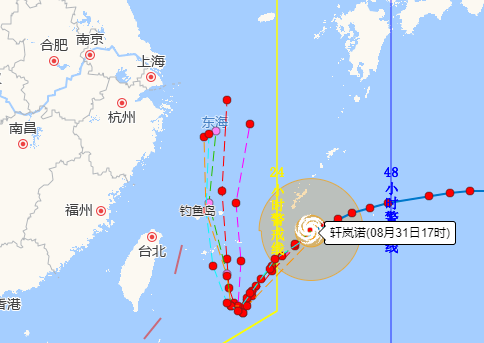
According to the Provincial Meteorological Observatory's forecast at 17 o'clock, the wind power of the East China Sea will be strengthened to level 9-10 from September 2nd, and from level 10-12 will continue to be strengthened to level 14-16 from the 3rd to 5th. Level 17 or above. Starting from September 1st, the wind and wind of the coastal sea surface have been strengthened to level 9, and the gusts can reach level 10-12 on the 4th to 5th, and the local level exceeds 13 levels. There will be shower in the coastal areas on the 2nd to 4th.
The Provincial Agricultural and Rural Department reminds the majority of farmers (fishermen) to pay close attention to the typhoon warning information and prepare for Taiwan. In particular, the sea fishing vessels should strengthen the observation and pay attention to the wind and waves.
Focus:
1. "Xuan Lannuo" has a strong intensity, and may be moved to less for a long time in the later period. In the next five days, it will have a continuous impact on the East China Sea area. Past vessels shall be transferred to the safe area to avoid wind in time.
2. At present, the situation of the atmospheric circulation is complicated. There is also tropical low -pressure activity on the south side of "Xuanlan Nuo", especially during the steering period, affected by the cold air eastward, subtropical high -pressure changes, and the interaction of vortex. It is not ruled out that along the sea along our province.
Edit: Pan Qing
- END -
Chinese Story | Father, I will become you when I grow up

When we were young, our father's shoulder was the Tower of the world, the closest ...
Famous scholar Professor Jobo is a guest "Paper Kite College" reading sharing event

Red Star News Network (Reporter Song Yating) On August 24, Li Bai relied on his ow...