Super Typhoon "Xuan Lannuo" approach!The scenic area was suspended, and Hangzhou's temperature dropped to ...
Author:Voice of Zhejiang Time:2022.09.01
Source: Zhejiang Voice Comprehensive Reporter Cai Jikang, Qianjiang Evening News, Ningbo Evening News, Wenzhou Commercial Daily, Zhejiang News, etc.
The copyright belongs to the original author, if there is any infringement, please contact it in time
Central Meteorological Observatory
On September 1st 06:00, the typhoon "Xuan Lannuo" forecast continued:
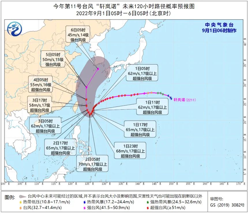
The center of Typhoon Xuan Lannuo (Super Typhoon Grade) No. 11 this year is located on the northwest Pacific Ocean on the northwest Pacific Ocean, which is about 510 kilometers east of Taitung City, Taiwan Province, which is 23.1 degrees north latitude and 126.1 degrees east longitude. , The maximum wind power near the center is above 17 or more (62 meters/s), the lowest air pressure in the center is 915 hundred Pache, the seventh -level wind ring radius is 240 ~ 280 kilometers, the 10th wind ring radius is 120 kilometers, and the 12 -level wind ring radius is 60 kilometers.
It is expected that "Xuan Lannuo" will slowly move south at a speed of 5-10 kilometers per hour. It will stagnate or virginity in the east of Taiwan on 1-2 on the 1st. Move, moved to the south of the East China Sea on the 3rd on the 3rd, and the strength was slowly weakened.

Although the typhoon "Xuan Lannuo" is small, the structure is firm, and the typhoon eyes are clearly visible
From the current forecast, it is expected that by September 5th, "Xuan Lannuo" will maintain a super typhoon level at a time of time or a week. It is expected that the largest wind near the "Xuan Lannuo" center will reach level 17 or above.
According to Hu Xiao, chief meteorological analyst of China Weather Network, from the perspective of cloud maps, the typhoon "Xuan Lannuo" has clear wind, complete and compact ring structure, not large but strong. Players, strength cannot be underestimated. Fortunately, the process of "Xuanlan Nuo" super typhoons is all at sea, with limited impact on land.
Judging from the current typhoon movement path released by the Central Meteorological Observatory, whether "Xuan Lannuo" can eventually land in my country still has suspense. In the future, it first moves stable towards the south of the south and continues to approach the coast of East my country in China; subsequently, or rushed northward in my country to the north, showing a unique "V" trend.
The sky in the Zhoushan Sea is gloomy, and the clouds are densely set.
Affected by the periphery of "Xuan Lannuo", the sky was gloomy yesterday, and the clouds were dense.


Yesterday morning, the Zhoushan Maritime Bureau issued a notice that due to the influence of Typhoon No. 11 "Xuan Lannuo", before 10:00 on September 1, a large number of fishing vessels will be returned to Hong Kong in the coastal waters of Zhoushan. Please drive carrier ships to drive carefully and avoid avoidance.
Ningbo Scenic Area: Exploresting Open
The Hengshan Island Scenic Area located in Qiangyu Town, Ninghai also stated that according to the requirements of the relevant departments, the Hengshan Island Scenic Area has suspended the opening of the outside world from September 1, and the leisure fishing boat returns to Hong Kong to avoid the wind and stop operation. If you open the notice separately, please refer to each other.
It should be reminded that the typhoon of autumn is aggressive and the walking path is uncertain. The general citizens who have intended to travel in the near future need to pay attention to the latest weather and scenic spots in real time.

Is Hangzhou cooler?
Hangzhou finally bid farewell to the high temperature in August, and devoted himself to a cool arms.
As the cold air is becoming more and more active, everyone does not need to use thunderstorms to achieve freedom of cooling. From the afternoon of the day before yesterday, due to cold air, Hangzhou's temperature decreased quality. The north wind, the lowest temperature yesterday morning was 23.6 ° C, and the highest temperature during the day was 25.6 ° C. It felt very cool and comfortable.
Such cooling is mainly the credit of cold air.
At the same time, the "Xuan Lannuo" continued to develop this year.
The Hangzhou Meteorological Observatory stated that the prediction of the "Xuanlan Nuo" path in the later period is not too clear. The subtropical high pressure is faced with a double impact on the cold air and the southern typhoon. Direction and influence of each other, the path uncertainty is greater.
Regardless of whether it logs in, under the influence of cold air and "Xuan Lannuo", in the early morning of September 1st, there will be strong winds in the East China Sea.
It is expected that from August 31st to the night of September 2nd, the southern waters of the Yellow Sea, most of the East China Sea, Taiwan Strait, Taiwan's East Ocean, and the bus Strait will be 6 ~ 8 to the northern wind of 9-10 gusts. Among them, of which The waters of the southeast of the East China Sea and the east of the east side of the East China Sea can reach level 9-12 and gusts 13-14.
In short, far away from these sea areas! For our province, especially partners in Taizhou, Wenzhou, Zhoushan and other places should not go to the beach. Sea ships should enter the Hong Kong to avoid wind in time!
Affected by the periphery and cold air of typhoon, the precipitation weather in our province will increase in the next few days.
In the next week, there are more than a rainy weather in Hangzhou, and the showers will mainly appear on September 2-4. Among them, September 3-4 has short-term heavy rain to heavy rain in the mountains and mountainous areas of Hangzhou. The temperature is also very friendly, basically below 30 ° C.
However, typhoons are the key factor in the weather in the future. A small change will bring a lot of changes in the weather stage. Everyone should pay attention to the latest developments of Taiwan wind and prevent.
Forecast for the next seven days
1st (Thursday): Cloudy, 23-30 ° C, northern wind level 4 gusts 5-6;
2nd (Friday): cloudy to overcast, short -term showers, 22-27 ° C, northwest wind 4-5;
3rd on the 3rd (Saturday): There are shower or thunderstorms in cloudy to yin, 23-28 ° C, and north wind 5-6;
4th (Sunday): Cloudy to Yin there is shower or thunderstorm ω, 24-28 ° C, northwest wind 5-6;
5th (Monday): Cloudy to Yin, 24-30 ° C, northwest wind 6-7 levels;
6th (Tuesday): It is sunny to cloudy, 20-29 ° C, northwest wind 4-5;
7th (Wednesday): Cloudy to Yin, 17-30 ° C, breeze.(Hangzhou Meteorological Observatory was released at 15:00 on August 31)
wx_fmt = png "data-nickname =" The Voice of Zhejiang "Data-ALIAS =" ZHEJIANGZHISHISHING "Data-SIGNATURE =" What you heard is happening. The Voice of Zhejiang, synchronize with the news. "Data-from =" 0 "0"data-is_biz_ban =" 0 " />
- END -
The National Development and Reform Commission of the Circles Division held a meeting of special work mechanisms for food conservation and anti -food waste

On the afternoon of July 21, Liu Dechun, Director of the Division of the National ...
Dreaming of the top of the snow mountain shine, the light of the light of the body, Sichuan agent, the top of Mu Shitag Peak

Qiu Xiaofeng Zhong Junbo Cover Journalist Yang YueyueMutig Peak, at 7546 meters ab...