Heavy rain and heavy rain are coming!Super typhoon latest move
Author:Shangcheng Published Time:2022.09.01

The highly watched super typhoon "Xuan Lannuo" has ran into the 24 -hour warning zone in my country last night. Today, the latest developments are here!
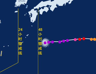
According to the latest news of Hangzhou Meteorological Observatory, the center of the "Xuanlan Nuo" (super typhoon) is located on the northwestern Pacific Ocean on the northwest Pacific Ocean about 470 kilometers east of Taitung City, Taiwan Province, about 1,000 kilometers from Hangzhou.
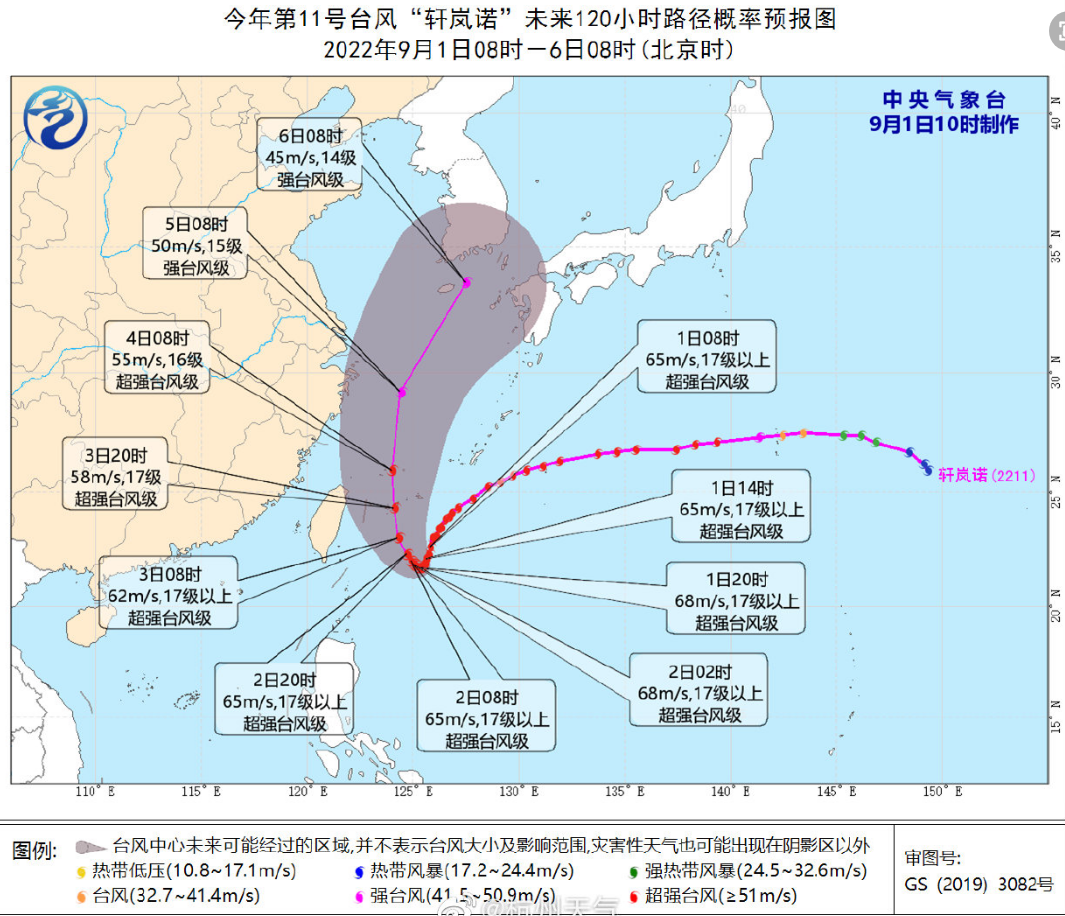
It is expected that "Xuan Lannuo" will slowly move to the south at a speed of about 5 kilometers per hour, and the intensity will be increased. Today, it will be moved by the southern ocean in Taiwan. The west moved to the west, and it was moved into the sea on the southeast of the East China Sea on the 3rd. The maximum likely to go north of 123-125 degrees east longitude.
As a "king -level" typhoon so far this year, "Xuan Lannuo" is indeed aggressive.
Swallow the new typhoon and complete the eye wall replacement
"Behind it", there is still room for strengthening
According to the weather in China, in the past day, "Xuan Lannuo" annexed the low pressure on the south side, which led to its size. At the same time, the "Xuan Lannuo" after the transformation will be strengthened to the second peak strength again. At present, the "Xuan Lannuo "'s maximum wind is above 17 or above (65 meters/s), and there is room for strengthening. Tomorrow will stop or rotate in the east side of Taiwan tomorrow, and then turns north to the north in my country, showing a unique "V" trend, and starts on the 3rd on the 3rd.
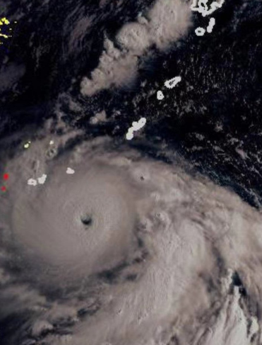
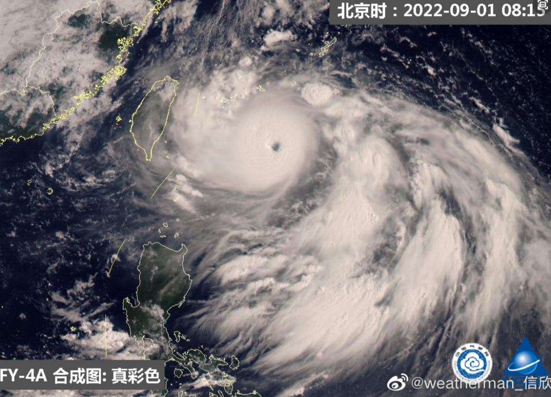
Eye wall replacement is a meteorological term, which can be understood in popularity, and from a typhoon eye to big eyes. According to the explanation of the meteorological blogger "Chinese Meteorological Lovers", in general, only a strong typhoon will look at it. During the eyes change, the typhoon intensity will be slightly weakened, but after a successful look, the typhoon will expand, the intensity will be expanded, the intensity will Will be enhanced. After Xuan Lannuo changed from small eyes to a big eye, the core circulation expanded greatly.
In addition, it also annexed the embryo of Typhoon No. 12 that may be generated. China Meteorological Channel Meteorological Analyst Xin Xin said that the original Typhoon Plum Blossom No. 12 has changed from difficulty to abortion. This low pressure was scattered by the powerful Xuan Lan Nuo and evolved into Xuan Lannuo's spiral cloud belt.
On the 3-4, there will be heavy rain to heavy rain in Hangzhou
There are still strong winds in some areas
The Hangzhou Meteorological Observatory said that the current situation of the atmospheric circulation is complicated. During the turning of "Xuan Lannuo", it was affected by the effects of cold air eastward and subtropical high -pressure changes in the north. The path is uncertain. Login needs to pay close attention.
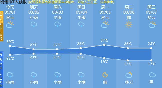
But in any case, the coming of rain is sure. Affected by the circulation of the "Xuanlan Nuo" typhoon, September 3-4 has heavy rain and local heavy rain. On the 3-5, there are 6-8 levels of level 9 or above in the central and northern districts and cities. The adverse effects of disaster weather such as rainfall and wind.

Source 丨 Hangzhou Daily Hangzhou Weather China Weather Weather Bureau Zhejiang News

- END -
"Khan" Wei Guang'an, the city of "hot" love in his heart

Don't be afraid of bakingPerseverance at 40 ℃Flame blue, not serving summerGoing ...
Guizhou Guiding: In the orderly completion of the first round of full -member nucleic acid testing in some areas
At 10:00 am on September 4th, Guiding conducted a total nucleic acid test in some ...