National Climate Center: Southern Central China and Most of East China may occur in summer and autumn drought
Author:Cover news Time:2022.09.02
Cover news reporter Teng Yan
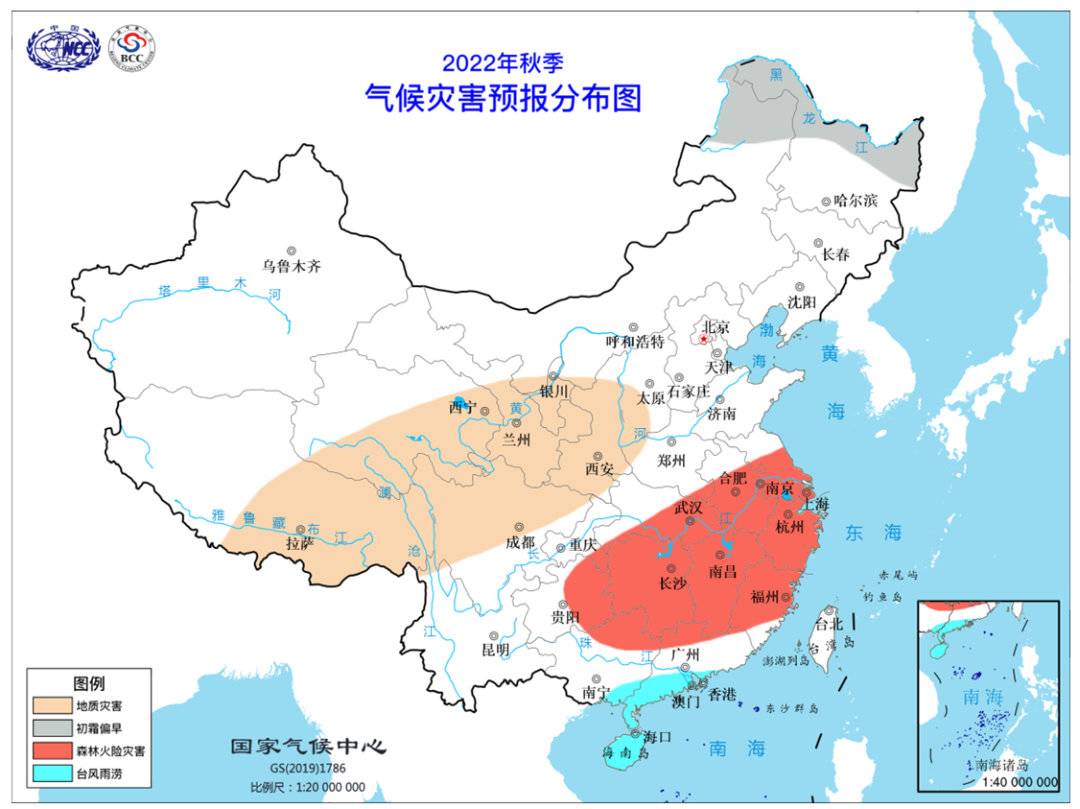
Forecast map of climate disaster forecast in the fall of 2022
On September 1st, the cover reporter learned from the National Climate Center that recently, the National Climate Center organized the meeting of the National Climate Trends Chamber of Commerce this fall (September to November 2022 to November). After analysis and judgment, the main predictive conclusions were formed.
It is expected that this fall, the eastern part of Tibet, the west and north of the south of Tibet, the eastern part of the north, north, northeast and northwest, northern China, central China, eastern South Inner Mongolia, southern South China, etc. Strong, but there are differences in the distribution of space; precipitation in other areas is close to fewer years, of which Xinjiang, southern China, and most of East China are 20 % to 50 % less than usual, and summer and autumn drought may occur.
It is expected that the temperature in most areas in my country is close to the high year, and the southern part of Qinghai, western Sichuan, Tibet and other places are 1-2 ° C, and the temperature will change greatly within the temperature season. The first frost date of most northern regions is late. There are 8 to 10 typhoons in the Northwest Pacific and the South China Sea, and 2 to 3 of them may significantly affect our country.
Most of Xinjiang, southern China, and most of East China have significantly less precipitation. It is estimated that in the fall of 2022, the eastern part of Tibet, the west of the southwest and the north, the eastern part of the north, the north, northeast and northwest, northern China, central China, eastern Inner Mongolia, southern South China, etc. The overall is strong, but the space distribution is different. Compared with the same period of the same year, the northeast and southwest of Inner Mongolia, the west of Heilongjiang, southern Liaoning, most of Hebei, Beijing, Tianjin, Shanxi, Shaanxi, Shandong, northern Henan, northwest of Hubei, northern Chongqing, northern Sichuan, west, Qinghai, Qinghai, Qinghai East, eastern Gansu, Ningxia, southern Guangdong, southeast of Guangxi, western Yunnan, and eastern Tibet are more precipitation than the same period of the same year. Southeast Tibet, southern Guangdong, southeastern Guangxi, Hainan and other places are 20 to 50 % to 50 %; precipitation from the rest of the country is close to the same period of the same year to less, of which eastern Hubei, southern Anhui, southern Jiangsu, Shanghai, eastern Guizhou, Hunan, Jiangxi, Jiangxi , Zhejiang, northern Fujian, northeast of Guangxi, and most of Xinjiang are 20 to 50 % to 50 %.
The temperature in most areas across the country is close to the same period of the year. It is expected that the temperature in most areas across the country is close to the same period of the year to the same period. Among them, 1-2 ° C in southern Qinghai, western Sichuan, Tibet and other places.
The first frost date of most northern my country is late. At present, there are no early frost in most parts of the northern part of my country. It is expected that the date of frosting in all regions in the north is roughly: northern Heilongjiang and northeast of Inner Mongolia in early September; northwestern Heilongjiang, central Inner Mongolia, and northern Xinjiang in mid -and late September; Tianjin, northern Hebei, most of Shanxi, northern Shaanxi, Ningxia, Gansu, central Xinjiang and southern parts in October; the rest of the north after November.
Compared with all years, except for the beginning of the frost in the northern part of Heilongjiang and the northeast of Inner Mongolia, the beginning of the frost start date in the rest of the rest of the northern parts of my country is close to the end of the year. East Gansu, central Xinjiang, northern Anhui, northern Jiangsu and other places are 3 to 5 days later.
In addition, 2 to 3 typhoons may land or significantly affect our country. It is expected that this fall, 8 to 10 typhoons (central wind ≥8 levels) are generated in the Northwest Pacific and South China Sea, which is less than the same period of the same year (11); 2.3). Typhoon intensity is generally weaker, mainly affecting the area of South China and the eastern coastal areas.
- END -
The "Five Port" instructions are lifted!Typhoon "saddle" scene picture!

Guangdong Meteorological Observatory NewsTyphoon No. 9 this year saddleAround 10:3...
Full City Meteorological Observatory to lift lightning yellow warning [Class III/heavier]
At 06:47, June 08, 2022, the Meteorological Station of the Management District was lifted.