"Xuanlan Nuo" approached, heavy rain and local heavy rain in some areas of Zhejiang!Provincial defense refers to increase the emergency response of typhoons to level III
Author:Published by Zhejiang Time:2022.09.02
Early morning yesterday morning
"Xuanlan Nuo" moves sharply
And stranded in the east of Taiwan
Weakened strength
Today at 05, weakened to a strong typhoon
However, the weakening of "Xuan Lannuo" is only temporary
Starting on September 3rd
"Xuanlan Nuo" will go north to re -enter the warm sea
It may be reinstalized
Typhoon latest news
//
At 17:00 today, Typhoon Xuan Lannuo, No. 11 this year, is located at 22.3 degrees north latitude and 124.7 degrees east longitude. It is about 370 kilometers east of Taitung City, Taiwan Province. The speed of the north is slowly moved to the west, and the intensity has not changed much. It will be moved into the East China Sea on the 3rd night. The intensity will be strengthened to the super typhoon level again, and gradually move towards the coast of the northeast of Zhejiang.
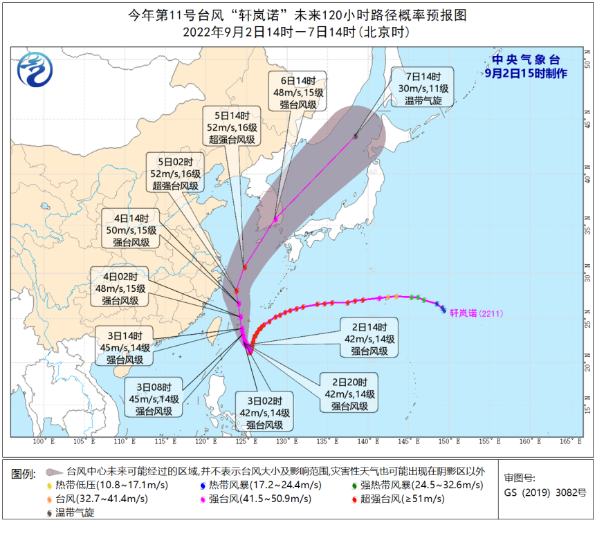
According to the "Zhejiang Province Flood Control and Drought Resistance Emergency Plan", the provincial defense index was decided to increase the emergency response of typhoons to level III at 14:00 on September 2.
In addition, at 14:00 on September 2nd, the Zhejiang Meteorological Bureau upgraded the typhoon emergency response to the level III.
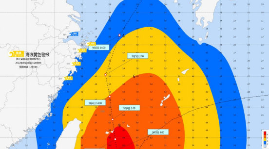
The Zhejiang Marine Monitoring and Forecast Center issued a yellow warning of the waves based on the "Emergency Plan for the Marine Disaster".
Affected by Typhoon No. 11 "Xuan Lannuo" (strong typhoon level), it is expected
Near -sea waters: Hangzhou Bay is from 1.2 meters to 2.0 meters of light to Zhonglang, and tomorrow evening will increase to the middle to large waves from 1.6 meters to 2.5 meters; there will be a large wave from 3.0 meters to 4.0 meters in northern Zhejiang. From 3.5 meters to 5.0 meters to huge waves; there are large to large waves from 3.0 meters to 4.0 meters in central Zhejiang, and will increase from 4.0 meters to 6.0 meters from a giant wave from 4.0 meters to 6.0 meters tomorrow. The big wave will increase from 5.0 meters to 7.0 meters tomorrow evening. The warning level of the sea waves in the sea is yellow.
Near -shore waters: Jiaxing has 1.2 meters to 1.8 meters of light to Zhonglang, and will increase from 1.6 meters to 2.5 meters in the middle to large waves tomorrow evening; Zhoushan has a middle to large wave from 2.0 meters to 3.0 meters. The big waves of 3.5 meters; Ningbo, Taizhou, and Wenzhou have 2.0 meters to 3.0 meters of large waves, and will increase to large waves from 3.0 meters to 4.0 meters tomorrow evening. Near -shore sea wave warning level is yellow.
Wave Police News
Impact on Zhejiang
Coastal wind
From today to tomorrow, the coastal sea gusts are 9-10; the 3rd from the 3rd to the 5th from the south to the north to 10-12, and the seas of the north coast of the central Zhejiang to the north are 13-15. On 4-5, the wind power of the northern coastal areas and Hangzhou Bay's water surface gradually increased to level 10-12, and gusts of gusts in the coastal areas of central and southern Zhejiang were also 8-9.
Rainfall
There will be shower in the eastern part of Zhejiang Tomorrow Tomorrow, and there are some heavy rains in the area. The rainfall on the 4-5 is even more obvious. There are heavy rain in the eastern region. There are heavy rain in Ningbo, Zhoushan, Shaoxing, and northern Taizhou, and local heavy rain. From the 6th, the province is mainly sunny to cloudy or cloudy weather.
Focus
"Xuanlan Nuo" has a strong intensity and large body shape. The wind of the East China Sea and the coast of Zhejiang lasts for a long time. At the same time, there is sufficient water vapor. There will be heavy rain in the eastern region of central Zhejiang. Please strengthen the adverse effects of preventing strong storms.
At present, when the summer conversion is conversion, the adjustment of the atmospheric circulation has certain uncertainty. The "Xuanlan Nuo" still has a large uncertainty in the later mobility path. Large. Please pay attention to the latest forecast early warning information in time.
The content is based on the Central Meteorological Observatory, Zhejiang Weather, Zhejiang Emergency Management, Zhejiang Ocean Monitoring and Forecast Center, etc.
Xue Editor: Ji Qunya
Editor in charge: Ding osmanthus
- END -
Ganzhou: The "old" residents enjoy the "new" life in the old community
Ganzhou Rong Media (Reporter Ren Ye) Ganzhou District has always adhered to the pe...
"Hundred Days Action" front -line fax 丨 Qiaojia and Zhenxiong have destroyed wild casinos successively

In the past few days, Zhaotong's public security organs at all levels adhere to th...