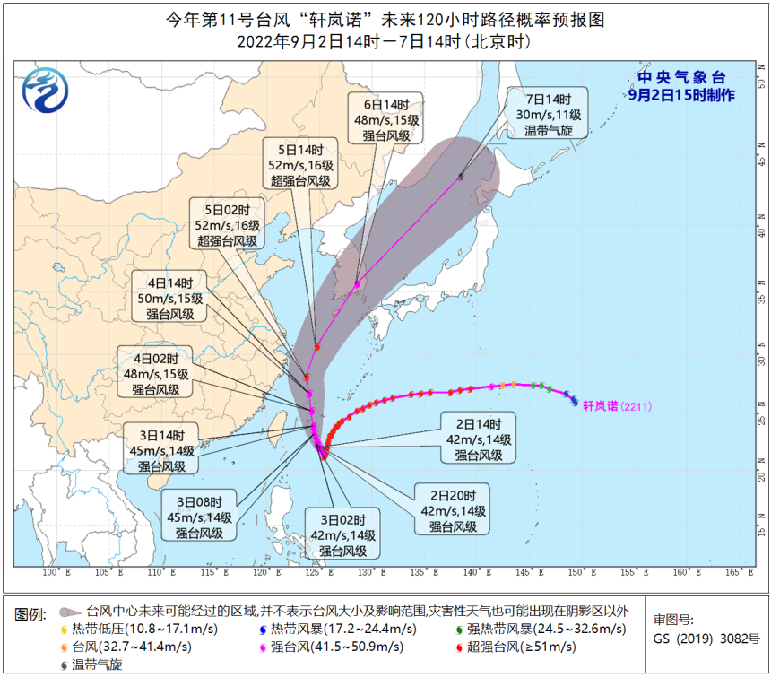
Strong path!"Xuanlan Nuo" may develop again into a super typhoon again!
Author:China Meteorological Administr Time:2022.09.02
2 pm September 2nd
Typhoon "Xuan Lannuo" Center No. 11 this year
Located in the east direction of Taitung City, Taiwan Province
About 405 kilometers of Taiwan East Ocean
The largest wind near the center is level 14 (45 meters/second)
The level is strong typhoon level

Typhoon "Xuanlan Nuo" dynamic map map/National Satellite Meteorological Center Han Bowei
What are the characteristics of "Xuan Lan Nuo"?
What is the future trend?
Typhoon and Marine Meteorological Forecast Center of the Central Meteorological Observatory
Chief Forecast Zhou Guanbo interpreted
↓↓↓
"Xuanlan Nuo" has a large scale, long duration, and strong intensity
The Central Meteorological Observatory predicts that "Xuan Lannuo" will move north to west of the west, and move into the East China Sea on the 3rd on the 3rd. The intensity will develop again. Essence From the night of the 4th to the morning of the 5th, it will move to the northeast of the Zhejiang Sea to the northeast, tending to the coast of the south of the Korean Peninsula to the area of Benshu Island, Japan.
"Xuanlan Nuo" is large, long, and strong, which will have a strong impact on my country. Zhou Guanbo pointed out that after the generation of "Xuan Lannuo", an annexed tropical low pressure in the south of his southern part made it larger. At the same time, due to the control of the subtropical high -pressure control, the early high temperature weather caused the sea temperature to be high, and the energy was supplemented to "Xuanlan Nuo", so that it within 24 hours (2:00 on August 29th to 2:00 on the 30th). Three ", upgraded from a strong tropical storm to a super typhoon. On the satellite cloud map, the structure of "Xuan Lannuo" is clearly visible, and this structure is only available in a small number of typhoons.
At present, the possibility of "Xuan Lannuo" landing on the eastern coast of my country cannot be ruled out. However, even if it is not logged in, due to the wide range of wind circles, large scale, long duration, and strong intensity, "Xuan Lannuo" will also affect wind and rain in the coastal areas of my country.
Affected by "Xuan Lannuo", from 14:00 on September 2 to 14:00, the Basta Strait, Taiwan Strait, Taiwan East Ocean, the South of the Yellow Sea, most of the East China Sea, and the waters near the Diaoyu Islands, the Yangtze River Estuary District, Hangzhou Bay, and as well as, and as well as The northern and eastern coast of Taiwan, the coast of the central and northern parts of Fujian, the coast of Zhejiang, the coast of Shanghai, and the southern coast of Jiangsu will have 6-8 strong winds, and the gusts are 9-10; September 2nd to 14:00 on the 3rd, eastern Zhejiang, Some areas in northern Taiwan Island will have mid -to -heavy rain. Among them, there are heavy rain in the northeast of Zhejiang, and heavy rain in the northern part of Taiwan Island.

Why is the "Xuanlan Nuo" path so unique?
"Xuan Lannuo" has a high latitude, and "gets out" has the first unique path of appearing since the meteorological records. The general typhoon is generated in the waters of about 5 ° ~ 20 ° north -south latitude, and the "Xuanlan Nuo" generation area is 25.9 ° north latitude, which is relatively rare. Due to the influence of the subtropical high pressure, "Xuan Lannuo" moved towards the southwest after the generation. The water temperature here is higher, which makes "Xuan Lannuo" strengthen it to a super typhoon level. At present, "Xuan Lannuo" is in the saddle -shaped gas pressure field, and the guidance of the airflow is weak. Therefore, it is kept in place.
It is expected that on the 3rd, due to the high pressure of Donghuan subtropical, and after the west wind groove deepen, "Xuan Lannuo" will move north to west and enter the warm water area of the East China Sea, which may once again develop into a super typhoon. Zhou Guanbo pointed out that it is very rare for typhoons to reach the super typhoon level in the East China Sea area. The global warming and the phenomenon of La Nina are the behind -the -scenes pushes that "Xuan Lannuo" is so special.
Zhou Guanbo reminded that the government and relevant departments should do a good job of preventing typhoon rescue in accordance with their duties. Related water operations and past ships should return to Hong Kong to avoid wind, strengthen port facilities, and prevent ships from anchoring, stranding and collision. Produced by China Meteorological Administration Xuanke Center (China Meteorological News Agency)
Author: Xu Nenyu
- END -
The parties responded to "send the residents back to the 6th floor home with a ladder car": remotely controlled the whole process without contact

Jimu Journalist Liu XiaobinVideo editing Zhou Xin
Ningbo, Zhejiang: Top Ten "Most Beautiful Calls" was born

Since the Ningbo Evening News opened on May 23, the Most Beautiful Courier was col...