Typhoon sent "air -conditioning machine"!More than 35 ° C, Xiamen rolled up three days from this day!
Author:Xiamen Daily Time:2022.09.03
Typhoon "Xuan Lannuo" that has received much attention
Completed the "V" shift yesterday
Starting the journey northward all the way
at the same time
TA also sent us
"Air Conditioner"
↓↓↓
Affected by the sinking air flow in the periphery of "Xuanlan Nuo"
Xiamen will continue to appear three days from this day
High temperature weather above 35 ° C

Let's pay attention first
Typhoon latest news
Central Meteorological Observatory
Continue to release today at 6 o'clock
Typhoon yellow warning
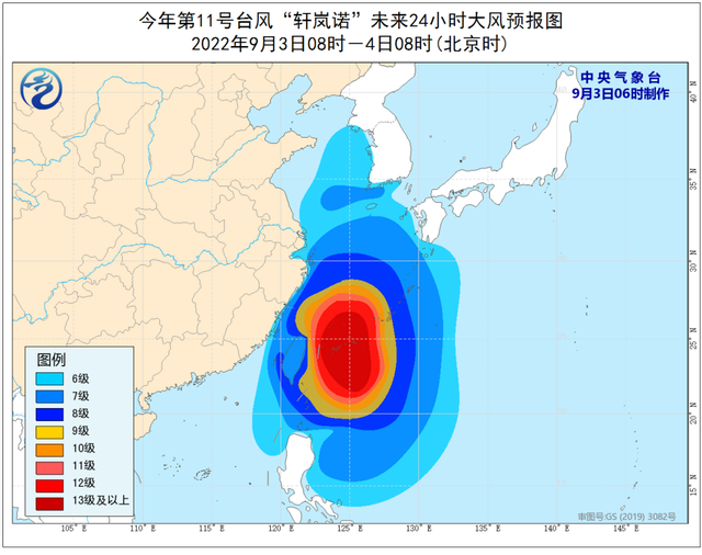
It is expected that "Xuan Lannuo" will continue to move north to the east, and the intensity will gradually increase, and it will be moved into the East China Sea at night; from the 4th to the morning of the 5th, it will move to the northeast of the Zhejiang Sea. Right and right, and then gradually moved towards the coast of the southern Korean Peninsula to the area of Honshu Island, Japan.

▼
Great Wind Forecast:
From 08:00 on September 3rd to 08:00 on the 4th, the bus Strait, Taiwan Strait, Taiwan's East Ocean, the South of the Yellow Sea, most of the East China Sea, and the waters near the Diaoyu Islands, the Yangtze River Estuary District, Hangzhou Bay, and the northern part of Taiwan and the coast and Fujian in the east, Fujian, Fujian The coast of the central and northern parts, the coast of Zhejiang, the coast of Shanghai, and the southern coast of Jiangsu will have 6-8 strong winds, and the gusts are 9-10. "The wind on the nearby sea passed by the center is level 13-15, and the gusts can reach level 16-17.
▼
Precipitation forecast
From 08:00 on September 3rd to 08:00 on the 4th, there will be heavy rain in northeast Zhejiang, Taiwan and other places. Among them, there will be heavy rains in part of the northern part of Taiwan Island, and the local heavy rain (250-350 mm) will be.

Three days from this day
Xiamen heat waves rolling
Introduction to meteorological experts
Typhoon is not always happy and refreshing
It will also bring high temperature weather
This is because the airflow rising sports area near the typhoon eyes, and its peripheral circulation is the air sinking movement area. The sinking air flow will make the sunlight reach the ground without blocking, resulting in the accumulation of heat and brewing high temperature weather.

Xiamen Meteorological Observatory
Published today at 8:42
High -temperature orange warning signal

Today
Multi -cloud weather in our city is mainly
There will be showers or thunderstorms on the outside part of the island in the afternoon
Don’t forget to bring a good rain when you go out
Tomorrow day
The city is still cloudy to clear the weather
The red sun is high, the heat wave is rolling
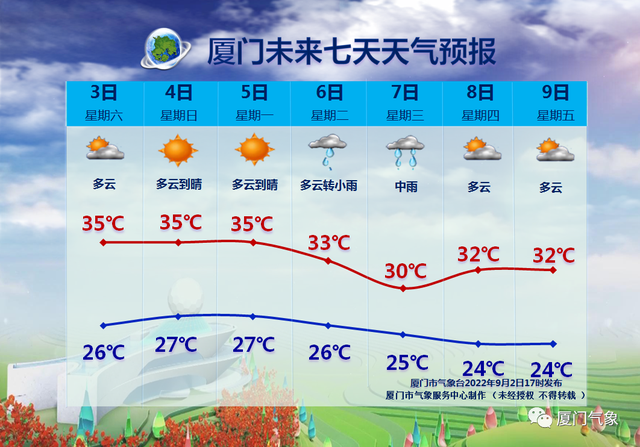
It is estimated that starting next Tuesday
The weak and cold air in the north south
There will be cooling and precipitation weather in our city
There will be strong convective weather such as lightning and short -term winds such as lightning and short -term winds.
The highest temperature in the urban area will drop to 30 ° C
Produced by Xiamen Daily New Media Center
Reporter: Zhu Daoheng Comprehensive Central Meteorological Observatory, Xiamen Meteorological,@记 记 记 记 记
- END -
2022 Qinghai Province "the most beautiful family" and "green family" demonstration household candidate list publicity list

According to the Notice on the Finding the Most Beautiful Family and Create a Gree...
Fahries and flood disasters in Datong County, Xining, Qinghai have caused 16 deaths and 36 people lost contact

The reporter learned that on the 18th, the Chase County Rong Media Center was info...